ayavner Posted September 3, 2013 Share Posted September 3, 2013 Sunday was a great day for flying, despite the shroud of smoke covering the Blue Mountains almost in their entirety. This was my first trip outside of my familiar area covering Bankstown - Camden - Wollongong. Original plan was to head to Katoomba - Oberon - Bathurst, but we had to change that once we got up in the air and saw that the smoke obscured the whole area! The weather report did mention smoke, but I had expected a few plumes here and there - but at least i halfway expected it so wasn't too suprised it was there. This gave an opportunity to do an unplanned diversion - we picked a prominent spot a bit to the south, Trial Hill and headed towards that and did a nice spiral climb to 7500' where we could see clearly over everything, and put down a positive fix and new time on my map. As luck would have it, from that point, i was able to parallel my original planned track and ended up in Oberon and Bathurst only about 5 minutes after original plan... well its not luck really... good preparation and CLEAROFFs really work! Landed in Bathurst after overflying and seeing the wind direction actually favoured the dirt cross strip. That was my first landing on a dirt strip, and it went really well! I expected it to be more difficult or something. A nice gentleman in the Bathurst Aero Club allowed us to use the facilities and use the space to have a stretch and talk about the plan back. This time, the plan was to forget the plan as we were going to get lost! by then the wind changed a bit, now favouring the sealed runway 17 so we backtracked and departed to the south. Once at height, Brett took away my maps and covered all of my gauges and compass and picked a heading of 150M and told me to just fly for 10-15 minutes. After that time, he gave me back my maps and instruments and said "OK get us unlost". So knowing where my last positive fix was, and my heading, as well as a quick calculation of ground speed I was able to find a probable area which I circled on the map - then things started popping into view - powerlines here, a river there, and before long a postive fix over Teralga. He then attempted to get me completely lost, but using the same principle, I was able to DR on some power lines and substations and eventually headed towards a couple of towns and prominent reservoirs which put me between Bowral and Moss Vale. Since the original plan was to have gone Bathurst - Oberon - Camden - Bankstown, I simply followed the rail line from Bowral to Picton to Camden, then back home! This was one of the best lessons ever, it is always encouraging when you get to take the theory and put it into practice and see that it really works. Does wonders for the confidence as well. Can't wait to go up and try it again and again... Next lesson is diversions, though we had a nice unplanned preview this time due to the smoke, and low-level navs. I'll post blog link when I get it posted, thanks for reading! 7 Link to comment Share on other sites More sharing options...
facthunter Posted September 3, 2013 Share Posted September 3, 2013 Watch that smoke. It got me into one of the most tight situations ever. Nev Link to comment Share on other sites More sharing options...
Bandit12 Posted September 3, 2013 Share Posted September 3, 2013 Me too - took off from Toowoomba once heading to Archerfield and the smoke over the range wiped out the horizon. By the time I had u-turned outta there, it was setting in around the airfield. Good lesson in how quick things can change, and how much better it can look from the ground. Congrats on the nav! Link to comment Share on other sites More sharing options...
kgwilson Posted September 3, 2013 Share Posted September 3, 2013 It's a great feeling knowing that all of the theory and map reading actually works in practice and proves you can navigate. Far better than looking at the GPS & accepting the technological solution. The maps battery never goes flat & looking out the window confirms your skills. Always fly above the smoke if possible. It is generally easy to see forward and down when above it but hard to see anything in front of you when you are in it. Link to comment Share on other sites More sharing options...
ayavner Posted September 3, 2013 Author Share Posted September 3, 2013 Watch that smoke. It got me into one of the most tight situations ever. Nev I'd like to hear about it if you have time! Bandit, you are 110% right it is astonishing how quickly things can change, and I have to say the biggest takeaway for me on this trip was how easy it is to be utterly convinced of where you think you are and are heading! 1 Link to comment Share on other sites More sharing options...
facthunter Posted September 3, 2013 Share Posted September 3, 2013 Not going into detail as it got serious but the main problem can be that flying along over top of smoke you can fail to notice the formation of mist fog or low cloud in the smoke. This is most likely early morning or particularly later in the day when the sun is a an acute angle to the horizontal. Obviously you are better above it as you can see most things ( except a climbing aircraft on your track). By itself if you monitor the vis below you should be fine but when you are running out of daylight and things cool a bit below it all becomes serious when you try to go down in the smoke which becomes fog. Nev Link to comment Share on other sites More sharing options...
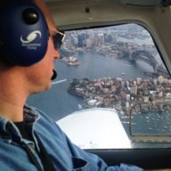
ayavner Posted September 3, 2013 Author Share Posted September 3, 2013 some piccies: somewhere between Oberon and Teralga: OK now what do you do?? Link to comment Share on other sites More sharing options...
dazza 38 Posted September 3, 2013 Share Posted September 3, 2013 I ended up with smoke becoming a problem once. I have mentioned it a few times before here, so I will keep it short. A Moonie and I in the Archer got pretty close to each other over the northern tip of Sth Stradbroke many years ago. There was a lot of sugar cane being burnt off at the time and he had a high pressure system. I could see down no worries, but the horizontal visibility was crap, actually it was that bad that seeing and flying level by looking at the horizon wasn't going to happen. I flew back to Archerfield using the AH. Link to comment Share on other sites More sharing options...
turboplanner Posted September 3, 2013 Share Posted September 3, 2013 Great work Ayavner, so after having gone through the exercise, and recovered track, what is your advice to people who just take off on cross countries with a gps and no nav skills or maps? Link to comment Share on other sites More sharing options...
ayavner Posted September 3, 2013 Author Share Posted September 3, 2013 Thanks turbz, so while I am not sure I am in a position to give advice, nevertheless I would say that person is taking their life and possibly others into their hands in a very foolish way. Besides, why would anyone want to learn to fly without learning all the stuff that goes with it? I took this on to challenge my brain and learn new concepts, not to just steer a chair in the sky. I can buy a cheap Jetstar flight and let someone else fly! That said, a GPS would be handy as long as its just used in a secondary way to confirm a position. The jab has a moving map system, and we just leave it turned off - not even sure how to work it lol. Dazza that's scary stuff, and i was definitely having all those thoughts while looking at it. If id have not been with the instructor, i'd have just turned around no questions. But at least now i have a couple of tools in case i'm caught out. 1 Link to comment Share on other sites More sharing options...
ayavner Posted September 3, 2013 Author Share Posted September 3, 2013 and, the official Crapping On version... http://morerightrudder.wordpress.com/2013/09/03/second-navigation-exercise-lost-whats-your-plan/ Link to comment Share on other sites More sharing options...
facthunter Posted September 3, 2013 Share Posted September 3, 2013 Mum seems happy. I think you have a pretty thorough instructor .Nev Link to comment Share on other sites More sharing options...
ayavner Posted September 3, 2013 Author Share Posted September 3, 2013 yes, my parents eat this stuff up :) Very happy with the instructor, even if I do get frustrated with the school and administrative aspects from time to time... i think I'll have no trouble transitioning to PPL, and that's definitely due to his thoroughness. Link to comment Share on other sites More sharing options...
Recommended Posts
Create an account or sign in to comment
You need to be a member in order to leave a comment
Create an account
Sign up for a new account in our community. It's easy!
Register a new accountSign in
Already have an account? Sign in here.
Sign In Now