

hkaneshiro
-
Posts
18 -
Joined
-
Last visited
Content Type
Profiles
Forums
Gallery
Downloads
Blogs
Events
Store
Aircraft
Resources
Tutorials
Articles
Classifieds
Movies
Books
Community Map
Quizzes
Posts posted by hkaneshiro
-
-
the sweet spot at the moment are the Sling 2 planes. Good hybrid between RAAUS / GA. Can train in one and easily get converted either way and performance isn't that different from a C152.
Realistically what does the increase in MTOW achieve? What are the other GA planes that can realistically be captured into the RAAUS system with an increased MTOW apart from the C152?
-
10 hours ago, old man emu said:
Would you give me the link, please?
Here you go for Basic
https://www.casa.gov.au/basic-class-2-medical-certificate-fact-sheet-pilots (see the checklist part)
-
 1
1
-
-
On 11/04/2023 at 8:19 PM, old man emu said:
He signs it. You send it. You wait. And wait. And wait,
o by the tie your get a reply from CASA, it has expired and you have to get your GP to do another medical
Basic Class 2 is simple if you pass
GP signs the form. You upload it to the CASA website and then print off your medical immediately. CASA dont even want to get involved.
For normal Class 2, one should go to a DAME2 who can issue one on the spot. Make sure your clarify that before booking your DAME2 (dont get one who wants to refer every medical to CASA despite their priveleges). In practice mine took 1 or 2 days to get issued, DAME2 told me he had to click a button his end and then the CASA automated system generated something for me to print out 2 days later...
-
 1
1
-
-
sometimes it feels more a rorty thing going the other way RPL-> RAA.
RAAUS specifies 5hrs, of which 1 hr solo and a check out by a RAAUS CFI.
A bit ironic...
-
On 09/04/2023 at 5:12 AM, old man emu said:
Please point out the logic in this situation.
At Camden there was a flying school operating Jabirus. One was VH-XXX and the other 24-9876. It was possible that both these aircraft were doing circuit work at the same time, each flown solo by a student. Camden is a controlled airport from 8:00 am to 4:00 pm, so a visitor in 24-&^%$ is not permitted to fly into Camden between those time.
Leaving out the fact that the flying school had a CASA exemption to operate the 24-9876, where are the safety issues involved in that? Bearing in mind that the student in VH-XXX might be flying on a Basic Class 2 medical and the 24-9876 is self-declaring, and both are making the same broadcasts, why can't 24-&^%$ fly in from The Oaks between 8:00 am to 4:00 pm?
My opinion is that by creating RAAus, CASA has caused more problems than it saved. A plane is a plane, is a plane, is a plane. As long as the design is sufficient for purpose, and the finished product is maintained to an acceptable standard why should VH-XXX and 24-9876 use the skies and the airports under different rules?
the VH student pilot will be on a full class 2 (cant take the RPL/PPL test on a Basic). Student 24-9876 will be on a full class 2 too (not self declared - they will not be able to solo in Class D/C otherwise)
therein lies the answer.. 24-&^%$ could be flying into Camden on a self-declared medical.
-
i think the biggest issue that GA guys have with RAAus is the more variable training standards with the latter. also testing requirements are different (CFI versus an authorised testing officer).
face it though, there is some regulatory arbitrage going on.. if i were a GA school, i woukd be tempted to do the combined RA/GA thing for efficiencies.
-
18 hours ago, KRviator said:
Victor 65 is described in the YPPH ERSA, same as the Sydney Harbour Scenic's are so described in the YSSY ERSA entry.
For YPPH V65 the route is CTE-PCTY-HKE, which translates to the VFR waypoints of Cottesloe-Perth City-Herdsman Lake and is what you would put in your ASA Flight Notification if that's your intent. For a Harbour Scenic, you'd plan via Long Reef. There's a lot more info and knowledge required than just what you see on a chart...
Ah this is actually good to know. An example of an unknown unknown - it didn't occur to me to look at YPPH Ersa when submitting my flight plan.
During my training lessons/flights for Victor 65, I could not find all the waypoints on the map to put into NAIPS but I asked my instructor. And he just said to put in CTE-PCTY-HKE for ASA clearance. And that made me wonder on how was one supposed to know there was a PCTY waypoint when its not marked on the VTC/VNC.
Similarly on another route - YPJT - BODD (Boddington mine). I knew there was BODD waypoint - but didn't see it marked on the VTC/VNC and was wondering how people knew about it...
-
6 hours ago, old man emu said:
For about $15.00 you can buy pieces of paper that have heaps of waypoints marked on them. You can even draw straight lines between those waypoints to see how far apart they are. You can even use a thing called a protractor to find the direction relative to North that you have to fly to get to the waypoint from where your starting point.

Case in point - I don't even know where this is on the map in Australia.
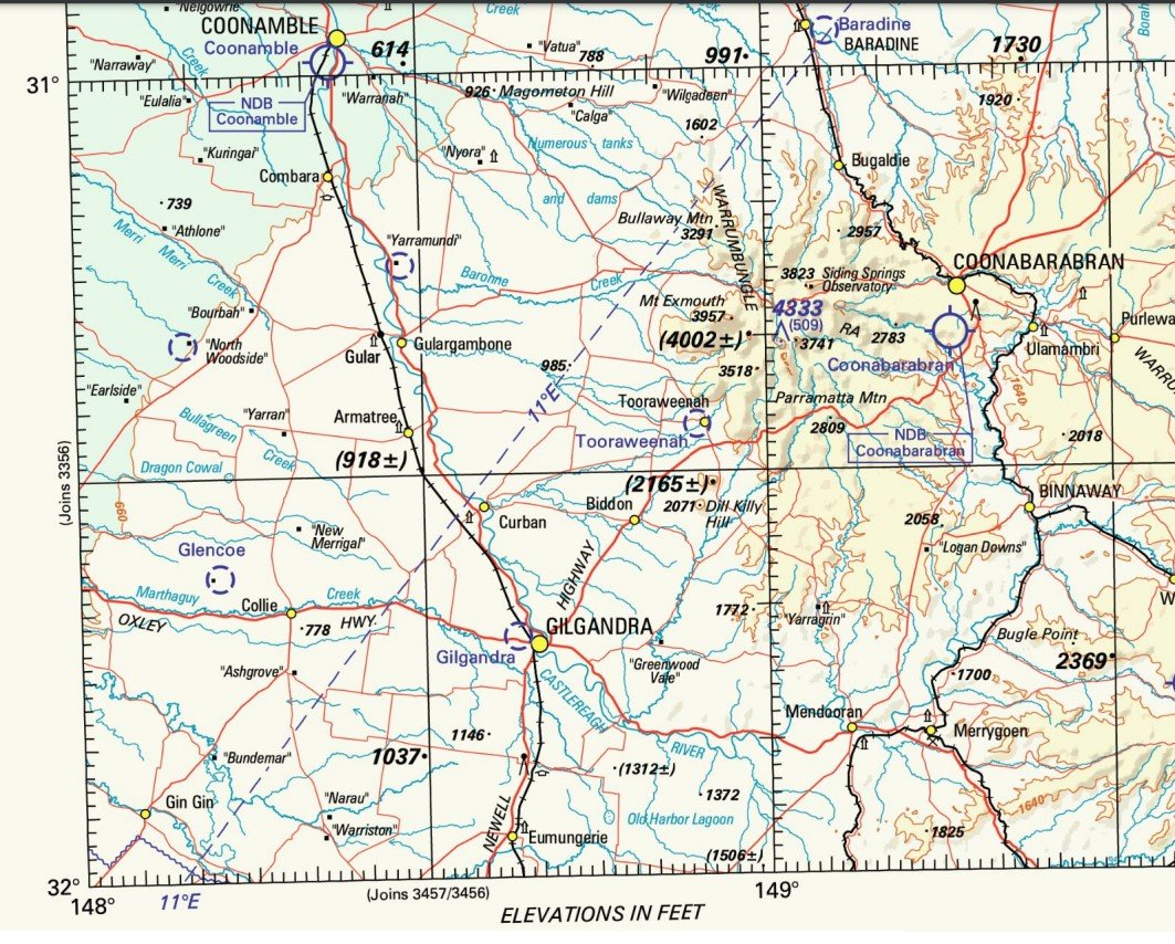
Let's say I want to fly COONABLE -> COLLIE -> BARADINE
How do I know what the waypoint are to put into my flight plan without it being specified on the map. COONABLE/BARADINE presumably have airport ICAO identifiers that make it easy. But COLLIE may / may not have a VFR way point specified
-
2 hours ago, old man emu said:
A waypoint is a specified geographical location used to define an area navigation route or the flight path of an aircraft employing area navigation.
Specified by whom?
On my piece of paper, I can specify any geographical location to use in my flight plan.
Here are the areas covered by VTCs in Australia and here are the VNCs Lots of blank spaces for you to fill with your personally specified waypoints.
6 hours ago, old man emu said:For about $15.00 you can buy pieces of paper that have heaps of waypoints marked on them. You can even draw straight lines between those waypoints to see how far apart they are. You can even use a thing called a protractor to find the direction relative to North that you have to fly to get to the waypoint from where your starting point.
There are VFR waypoints listed in the ERSA. Which you can translate to putting into a flight plan to inform Air Services in the NAIPS. Question is finding one that is an official one so it is easy to file a flight plan. For example - in Perth there is this thing called the Victor 65 Perth City orbit - the way points in that are not specified in the VTC/VNC so I only knew what to put into my flight plan by asking around. I'm sure that Harbour Scenic 1 in Sydney is the same?
If there is no VFR way point specified, I was told the proper method is to specify the Latitude/Longitude in system (I don't know how to do this, but it seems trouble some if there was actually some official one nearby that you could have used.
7 hours ago, Bosi72 said:Most vfr points are on vnc/vtc but not all.
Turn on "vfr waypoints" option in your efb to see them all.
With regards to airservices, and assuming you are in flight, you can tell you are X miles N/S/W/E from such and such township, they will tell you sqawk ident, then they will know your position.
got it - yeah looks like an EFB is in order if I wanted to conveniently/visually see the way points for flight planning purposes.
-
I was just wondering if there was a published map of VFR way points? I know its listed in the ERSA alphabetically. However it strikes me as thing being a potential issue of having a "unknown known".
I.e if i am planning a flight in an unfamiliar area, how would I know if there is/was a VFR waypoint somewhere to notify Airservices of my flight plan?
-
first solo is overrated. i hated my first solo and the hype / pressure to get there (i was under a time constraint given i was doing an intensive course) and weather / x winds were not favourable.
wasted so much money on pre solo circuits only to have the solo cancelled due to weather conditions
-
 1
1
-
-
46 minutes ago, spacesailor said:
pfl & psl , please elighte .
I,m not good on abreaviations .
spacesailor
apologies should be
practice forced landing (pfl)
precautionary search and landing (psl)
-
from what I understand (for RPC - via watching an online video behind a paywall https://gofly.online/Video/how-to-pass-your-flight-test-hd/) + my recent experience with a CASA RPL test (which was very similar)... the test goes about like this
1. Taxi, takeoff and head to training area
2. Climb to altitude - as part of this showing the examiner your climbing, turns, S&L
3. Stalling (HASEL), recovery from incipient spins
4. Steep turns (not sure if this is in RPC syllabus)
5. PFL
6. MAYBE a PSL (I did not do one for CASA RPL as it is not a required testing element)
7. Back to do a few circuits - flapless, crosswind (maybe an EFATO if not done already in #1)
That's about it from what I recall (NB my CASA test also had some IFR "hood" work and recovery from unusual attitudes under the hood which was done on the en-route climb to altitude - but don't think this is also in the RPC syllabus)
Some examiners may ask you to do circuits first before going out to training area...
-
Im actually doing it in reverse 🙂
RPL to RPC (and getting all the endorsements etc), then adding them back to my RPL haha.
Time to save some money... -
So I have spent a bit too much during my RPL and am thinking that I needed to save some dosh going forward.
Would it be possible to do the following
1. Join RAA and get the RPC conversion from the RPL (5 hours I believe - I wanted to also do it in a taildragger to get a new endorsement)
2. Get X-Country Nav under my RPC
3. Then add the RAA/RPC taildragger+X-country Navs to my RPL
i guess the difference here is that I never did an initial RPC-> RPL conversion with that CASA form. Does this change anything or can I add some of the RPC endorsements added to my RPL later? I could not find a special form.
-
thanks everyone for their comments and good to see this thread has morphed into something different
i actually was seriously contemplating doing RPC->RPL (seemed cheaper) -> PPL, however I could not find anyone around my area who could credibly explain the process of "activating" the RPL post RPC (i.e. how many hours will it take to do the RPL GA flight review, which GA school will do it, how many hours on average etc), so it was very hard for me to budget. In the end, the GA school was willing to walk me through their RPL/PPL process so I went with them.
On hindsight, with a bit more reading/information I should have just gone RAA/RPC -> RPL (frozen). Then continue with a aerobatics/tailwheel endorsement to activate the RPL. Would have been cheaper and I will be learning new skills I think. As it stands, I intend to do a UPRT/tailwheel course after RPL before progressing with navs to get my PPL anyway.
I have also heard though that RA planes are harder to land and are more zippy - I have yet to try this but given I'm just a student pilot, I guess my choices are limited. Maybe I should try a foxbat or a tecnam sport as they seem to be available for learning in around my area
-
im thinking of getting an RPC after RPL training in a C152.
What is a fun and non docile plane to do the conversion in?
Foxbat? Tecnam? Jabiru? Evektor? Sling?
Im unsure what to do but I want to handle a funky airplane as a student
Leighton Beach WA light aircraft ditched 20.04.2023
in Aircraft Incidents and Accidents
Posted · Edited by hkaneshiro
great skill and was lucky to be near the shore.
watching the video maybe makes you a bit less hesitant to ditch in the ocean? i always thought the risk of doing a cartwheel was fairly high on a fixed undercarriage plane.