

Captaincoop
-
Posts
89 -
Joined
-
Last visited
Content Type
Profiles
Forums
Gallery
Downloads
Blogs
Events
Store
Aircraft
Resources
Tutorials
Articles
Classifieds
Movies
Books
Community Map
Quizzes
Videos Directory
Posts posted by Captaincoop
-
-
Quite right. Temperature affects take off performance (weight and or distance) but once airborne stall IAS remains the same. Engine power is decreased abut at low level like that there would still be plenty of power available.Stall speeds don't change if our density altitude is higher (warmer temp) do they?IAS stall speed remains the same. Our TAS has increased (and our groundspeed too) though.The engines might not be developing as much power (though not sure just how much less such temperatures would cause).
Yes? No?
I know that the 4 H's (High, Hot, Heavy, Humid) reduces performance but I've not learned exactly how to quantify it...
-
My point is that ALL possibilities must be considered. Those are just some of the things that need to be looked at rather than making a decision based on just looking at the video (which of course will help) As a qualified air accident investigator, I can say that there are many things to be looked at besides the "apparent" obvious stall.How would the flight path of the aircraft as depicted have taken him into low level windshear?There's a lot of opposite (right) aileron in there, and no rudder. As I said earlier, instinctive, but very detrimental if the aircraft is stalled. If it was a left engine failure the immediate application of right rudder would be expected too, as any multi-engine pilot would know. Yet there is none.[ATTACH=full]48031[/ATTACH]
[ATTACH=full]48032[/ATTACH]
As for low level wind shear in the depicted photo, that is way past the point at which I am referring. I meant that it is one POSSIBLILITY that the aircraft encountered undershoot shear leading to the flight path in the frame you have chosen. Out of the hundreds of approaches I have flown into Perth, (in daylight) it is very rare I have not experienced low level overshoot and undershoot shear. The altitude at which the aircraft appears to stall looks to be 250-300ft if that. Right where the shear is common. The early info is the it was hot and gusty on the day.
As any multi engine pilot knows, full (or worse partial) engine failure on the inboard engine is very hard to recognise, particularly if there is strong drift at low level. At that level in a high drag aircraft, identifying the dead engine when already flying slowly in the few seconds he has may simply prove too late, particularly if the aircraft is close to VMCA and so far back on the drag curve.
I've have found it difficult to identify the failing engine at 200ft with full flap at approach speed, and that was on a straight in approach, in a turn it's even worse.
If , however, you feel you have the whole thing sorted, ring ATSB and see what they say
-
 1
1
-
 1
1
-
 1
1
-
-
That's right.........Isn't RJW asking about using them in flight? Cartage of the battery is different.Technically Captain it seems to be a limit to the size of battery you can use in flight, doesn't appear to be a size limit if you are just carting them and using them at your destination.dangerous goods for commercial flights may differ slightly to private ops too.There may be some differences for private flying but I can't find any reference for it. It's all ICAO D.G.'s far as I know, but I'm happy to be enlightened if someone finds a reference in the regs or elsewhere.
-
1
-
-
There is a legal limit to the size battery you can carry. work out the watt hours of your battery

-
 1
1
-
-
I want one
-
Certainly has all the hallmarks of a stall but one thing you never do in accident investigation is jump to conclusions. Left engine failure or partial failure (critical engine), control problem, pilot incapacitation, low level wind shear....so many possibilities to consider and yes a stall in the turn is just one of them. Let's wait for the examination of the wreckage before we jump to the good ol "pilot error" conclusion do you think?
-
1
-
 1
1
-
 1
1
-
-
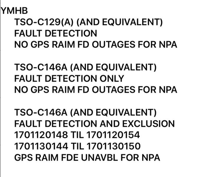
Quite right!That's for FDE tho, wouldn't have any effect on enroute or lower requirement approach. -
Only six minutes but if you didn't check the RAIM and you were flying in the high country and didn't know how to map read because GPS is so reliable, I'd say six minutes would be a very long time
-
2
-
-
Yeah that makes sense and 100 is a good figure for quick calculations off the top of ones head. 60nm = 0.6 =36 minutes...perfect!Yep you are right about the lowering the TAS for planning - Which is what I do. I drop it to 100 knots and that then generally buffers for small headwinds and gives a reserve. (added to which I have set up my fuel gauges so that even when they are showing empty I actually have about five litres in each tank (usable) plus the header tank of 6 litres (usable) so I have about 35 minutes at 2900 rpm.Using the 100 knots for planning has an added bonus. At a quick glance of the planning table its easy to calculate cumulative distances or times across multiple legs and flights (do the whole 10 day flight as one flight of a series of legs and you can easily work out total flying times and distances.Distances or times - every 100 miles is an hour and every hour is a 100 miles.
Have to admit I don't fly any distance often without starting with full tanks. Allows plenty of scope for holding, diverting etc.
-
Fair enough. We all use GPS nowadays. I have 5 for cross country and charts! The beauty of Avmap or Ozrunways is you don't (or shouldn't) need the GPS to be working. You still have the (digital) charts. Of course if the GPS sat system does fail (unlikely or very unlucky) or you are out of RAIM (I'm sure you check that as part of your preflight planning) then 100 GPS devices wouldn't help with positive position fix! That's why map reading skills are still basic airmanship.Cruise TAS at 110 knots. Climb at 90 knots indicated.Most legs I do I only travel about 2-3 hours at a time, on long trips. Sometimes 3 or 4 hours without a break, but not commonly.When it comes down to holding planned track. Whether it was forecasted and its wrong or whether I plan on still wind and its wrong - it's still wrong. But Even If it the forecast wind is right you still have no more certainty that it's right than comparing Map-Ground as you do when you use still-air planning.
But I use the dynon/GPS, ipad (Ozrunways), hard copy map with a line drawn on it and bounce the info off all of them against each other and ineveitably follow the line on the GPS and have always got to the required spot at the other end.
The old hoary argument of "what if your GPS fails" is redundant now. If my GPS fails I go to my ipad. If that fails I go to my second iPad if that fails I go to my iphone and if that fails my passenger has their ipad and then their iphone.
I haven't flown (apart from local stuff) with less than 4 GPS in the aircraft for more than a decade and often 6 to 8 GPSs.
I guess not planning for winds is ok if you never leave home without full tanks. I would have thought to do it that way would make more sense to plan on a lower TAS (like 90kts) to allow for unexpected winds then update enroute. Trouble is as I see it, with such slow speeds little wind is needed to have a large percentage effect on your ground speed. Like if you encounter a 22 knot headwind, there goes 20% more fuel than you banked on.
-
Really? What is your TAS?In reality the altitudes I fly at mostly mean that climb is not more than a few minutes. I reckon I fly most of my flying at 3500 to 5500 ft So it doesn't change things much. But if I was spending a lot of time in the climb or descent then I'd answer your question by limiting it to en route.As for planning - I now ignore winds completely in my planning. I used to consider them if there were forecasted strong headwinds ( in the days when my previous aircraft had limited endurance so fuel was a real consideration). Now days my fuel tanks far outstrip my bladder for endurance so I rarely have to consider the effect of headwinds on fuel.But in reality the errors were so frequent in forecasted headwinds that they were no more helpful to consider them than not.
I plan using my still-wind TAS.
-
Don't bother with that, just choose the chart for your flight and its self explanatory
-
Where is your flight plan from/to and at what level. I'll try it with my OR
-
I think you are saying that forecast winds could be more accurate than the Dynon. Sorry but that is not reflected in actual outcomes or measurements over hundreds of hours and thousands of miles of flying. Experience vividly shows exactly the opposite.I have flown many many trips where the GPS is able to calculate to within seconds the correct actual arrival time at destinations and maintain the correct heading and track throughout the whole leg by taking into account the winds it calculates. so one has to assume that by its very outcome it was correct and displayed little or no variance (inaccuracy).
The Dynon has sensors for all of the parameters needed to calculate the wind aloft. Static Air pressure, temperature probe, indicated air speed, compass and GPS location ( track) at fractions of a second intervals and a clock. While there are intrinsic variation in the accuracy of the sensors you have to keep it in perspective. These are minute, comparatively.
The variability of the outcome of a formula is more accurate when more of of the parameters are actual measurements and less accurate when it relies on more derived parameters.
Most of the parameters needed are measured not derived. Apart from the minimal variability of the relationship between altitude and air pressure so there is likely to be no or negligible variance ( accuracy ) in the TAS.
I don't understand what you mean by "heading not held". My understanding is that until you hold it it is not a heading. A heading is not a derived direction it is a measured direction by the compass ( magnetometer in the case of the Dynon) so except for the minimal intrinsic inaccuracy of the magnetometer it is otherwise a fixed measurement.
The track is derived from the GPS positioning which is these days mostly within an inaccuracy of about 10 metres or so.
So overall within the minimal amounts of inaccuracy of the sensors the winds aloft is going to be accurate and has been shown to be accurate in use.
On the other hand.
Forecasted winds are hugely broad estimates derived from measurements hundreds or thousands of kilometres apart and calculated according to guesses of temperatures and pressures which generate the air pressure differentials. They have been shown over and over again to be inaccurate, in actual use.
So much so that there are a myriad of well described techniques for working out errors in flight, for mitigating errors in flight and for salvaging poor positional outcomes once the hoped for destination has not hoved into sight at the expected time.
When you say the GPS is spot on within seconds, is that from top of climb or enroute, because it constantly updates itself? I'm sure it is accurate at top of climb for a short flight of a couple of hundred miles (in Australia) What winds do you use for planning purposes?
-
I think we re forgetting that the the original post was for flight "planning", of course once we are in the air we have to make an adjustment for the actual winds aloft. Before we had these wonderful gadgets we still he to flight plan based on the best available info and then once in the air, check track, ground speed HDG etc to work out the actual winds for the flight.
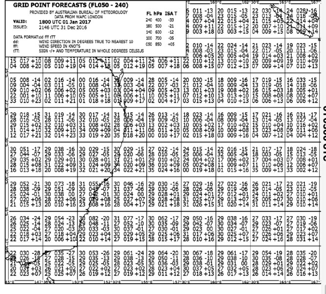
The question is which do we PLAN with GRIB or area for planning purposes. It's up to you and I suppose it depends on how far you are flying. GRIB is an interpolation of winds so I use them. When I fly for work we use GRIB and they are surprisingly accurate. Time and fuel burn are very close to plan but that doesn't mean we don't check actual along the way, particularly if a level change is needed for turbulence or to get better winds. If that is required then the new level GRIB winds are used. I don't have sofisicated Dynon when I fly (no panel space) but even the flight management computer in the Boeing uses the actual winds at its present position then blends them with the forecast winds (pilot entered) to 100nm ahead and then only to entered forecast winds after that, to arrive at an estimated time and fuel overhead destination. Also area forecast winds are just that-forecast. GRIB winds are based on forecasts, interpolation, weather balloons and pilot reports, so for PLANNING proposes I prefer them. If you don't plan with something how do you plan? Unless it's a short flight using the actual winds at your precise location and applying that for the rest of your flight could prove to be a bad prospect.
-
2
-
1
-
-
-
GRIB is best but can make sure it's not too old a forecast
-
1
-
-
You can get anything if you wanna pay for it. Probably cheaper to have a reliable marshaller tho
-
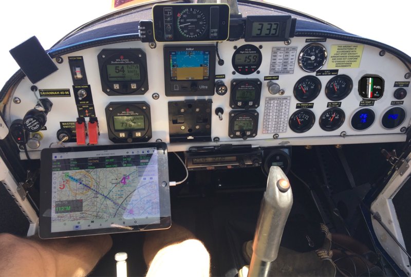
I mounted my iPad Air on a simple clamp bracket with Velcro. It sits out of the way and in a comfortable reading position easy to use the touch screen while still resting my elbow on the armrest I installed in my Sav. It also keeps it cool and out of the sun
-
They had a ground marshaller/wing walker. He signaled all was clear during the turn. When they clipped he ran away and could not be found again that day. If you can't trust the ground marshaller why have them there? It's very hard to judge distance off the wingtip way back behind you. It's not usual to crane your neck over your shoulder with your head pushed up against the side window to try to see the wingtip while taxiing around a corner onto a taxiway....you tend to trust the marshaller. Might be a bit of pontificating on this thread me thinks.
-
2
-
-
Prior to entering the class D airspace one would assumeFrom how far out do you have to be 1500ft? -
I applaud what you are trying to do. There is a chunk of Amberley control airspace that needs 2 miles of trimming to stop forcing VFR right against the hills at low level. Not only a problem for engine out, but also for turbulent conditions in moderate winds.
-
1
-
-
I use the next one up from this on my 912ULS. I did plenty of research beforehand. 700 CCA kicks it off nice. The weight went from 7kg to 1.7kg and improved C of G.
I have flown 150 hours with it. They are the only ones I know of that are ok for aircraft.
-
1
-
-
Having been in an aircraft that filled with Electrical smoke, I will happily take the 7-8 kg weight penalty and not be worried about in flight fire.Trust me when I say a smoke filled cabin is about the worst thing you can imagine.
Hell I would take a 20kg penalty rather than relive that 10 minutes of my life.
What caused the smoke?

Swan river incident
in Aircraft Incidents and Accidents
Posted
I don't follow what you are saying re windshear? It occurs at any level as you know, and if one were flying low and slow near the stall then undershoot or a sudden loss of airspeed is going to tip the scales against you? Unless you mean you have to be changing altitude to encounter windshear? Im sure you would have encountered undershoot shear (be it straight and level or even in tightish turn) on a windy day?