Coop
-
Posts
214 -
Joined
-
Last visited
Content Type
Profiles
Forums
Gallery
Downloads
Blogs
Events
Store
Aircraft
Resources
Tutorials
Articles
Classifieds
Movies
Books
Community Map
Quizzes
Videos Directory
Everything posted by Coop
-
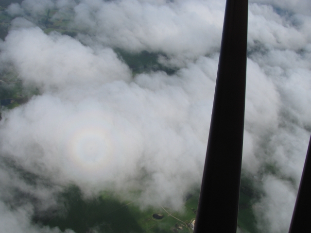
The run from home base to Kangaroo Island is pretty routine these days- but the great thing about aviation is that no trip is ever completely routine. This one proved to be no exception. The weather looked OK, but as we proceeded south the cloudbase clamped down onto the hills, as it often does over Fleurieu Peninsula. We diverted towards Goolwa, thinking that we could at least get a coffee there if we had to wait a while. But the cloud cover appeared to break up as we moved that way, and secure in the knowledge that we could always turn back to the east where the clouds were only scattered, we decided to pop up through a hole and go over the top. With full power applied and one notch of flap, Dorothy hauled us up through a hole in the thin stratus to 5000'. The temperature dropped noticeably, and the draught through the cockpit floor ensured we didn't get sleepy! The return run later that afternoon produced the same conditions, so we did the same thing. This image shows the view through the cockpit window as we crossed Backstairs Passage (sorry about the bugs on the windscreen- you can tell its springtime...). [ATTACH]640.vB[/ATTACH] The next one shows the coast near Cape Jervis- the greenery certainly won't last long once the summer arrives. [ATTACH]641.vB[/ATTACH] The third image is out the other side of the aircraft showing the wind turbines at Starfish Hill. [ATTACH]642.vB[/ATTACH] The last one shows the results of the Navigator's efforts to capture the circular rainbow that appears around Dorothy's shadow. [ATTACH]643.vB[/ATTACH] Getting above the cloud level almost always produces beautifully smooth conditions, and I usually leave the descent as late as possible so as to prolong the experience. Coop [ATTACH]17964[/ATTACH]

-
G'Day Lyn, Hey, the bit you are learning now is the hardest part.It's a very finely judged visuo-motor skill, and it doesn't come immediately. Lots of people experience rapid improvement, then a "plateau" where they don't think they are getting any better. If this happens to you, this is NOT the time to give up, because what's happening is your brain is making the transition from a skill you have to think about to one that happens automatically, without having to think about it. Just keep at it, and one day it'll all fall into place, just like Dazza said. Probably the nearest comparable skill is riding a bike- and that only happens in two dimensions!! Keep at it- it'll come soon, Regards Coop
-
Qatar Airways A333 Hard Landing* Manchester Airport
Coop replied to airbusfanforever's topic in Aviation Videos
I'm glad he says "Not a hard landing in the true sense..." because it isn't a hard landing at all. A little firm, maybe, but I doubt the customers noticed much difference. Coop -
Seems like they are recycling the name. Shows a lack of imagination- can't they think of another name and leave history alone? This will ensure that future generations will be confused.... there's enough of that already (even the Tiger Moth wasn't immune). Coop
-
G'Day Dave and Darren, Happy to oblige- glad you got some enjoyment from it. I certainly did! I'm off the the UK in a week's time, and may look in to Redhill, and will keep an eye out for these little beasties, Regards Coop
-
Thanks, Sixties. I'll post this link to the folks who own it now- dunno if they have images from its history. Looks like the undercarriage got changed some time during its history- now sports a simple spring steel system. Regards Coop
-
Yep, been a long time since I overflew Adelaide, but same here, they usually offer you the coastal route (which takes you past the end of runway 23 and may involve a delay) or the overhead route which takes you straight over the top of the airfield, out of the way of traffic departing either direction or arriving from either direction. It's actually the safest place to be, save the odd helicopter or two... Coop
-
Vne is 110 knots. Only got it up to 100 knots during this flight- you really feel like you are moving (and you are!). The airflow around the cockpit gets a bit fierce. How fast you go in level flight depends upon how much of the engine power you use. I only had it to about 85 knots in level flight- dunno how much throttle was left- wasn't paying attention, but it can probably reach its Vne in level flight (or nearly so). No, no plans to upgrade Dorothy- her sedate performance and low stalling speed are very relaxing.... :-) Coop
-
A “Turbulent” Day at Aldinga Up to today the smallest conventional aircraft I had ever flown (this obviously doesn’t include a brief interlude with hang gliders when I was at uni) was the Grunau Baby II glider, with an empty weight of about 170kg and a max weight of 250 kg. It’s max speed was set at 65kts, somewhat slower than the 80kts usually mentioned in the Grunua’s specifications- perhaps due allowance was being made for its age!! It also had a heavily curved wing section and an unbelievably slow stalling speed around 15 knots!! I remember this well, because during the landing, it felt like I could have got out and walked! This weekend, tho’, I got to fly an even smaller machine, with a lower max weight, even though it has an engine. I got to fly a Druine Turbulent. It was 19-0908, the first home-built aircraft to fly in Australia (previously VH-PWH). It was built in Sydney by Peter Hodgen in 1957-58. It is now owned by Martin Smith of Adelaide Biplanes at Aldinga, and he was gracious enough to allow me to do a few circuits. This machine is a mere 5.3M long, with a wing span of only 6.5M, an empty weight of about 160kg and a Max weight of about 280kg. Standing next to it, it looks like an overgrown model- although these days, there are even R/C models almost this large! One unusual feature is the presence of leading edge slots in the wing ahead of the ailerons. This machine was originally equipped with a converted VW engine of about 45hp, but was subsequently fitted with a 1600 Jabiru of 65hp, and recently a 2200 Jabiru of about 85hp. Given it now has an engine twice as powerful as the original specification, it’s performance is sparkling, to put it mildly!! My first concern was whether I’d be able to fit into it- and it was a bit tight, but since you can get full rudder travel with only ankle movement, and the throttle wasn’t obstructed by my left knee, it was OK. The fuel tap on this machine was directly in front at the bottom of the panel and the gauge- a wire on the end of a float- pokes straight up through the fuel cap in front of your eyes, so there’s no excuse for running out of fuel. Starting is easy- turn on the fuel, pull the choke, turn on both magnetos, push the starter, and away she goes. My instructor held the beastie back while I did this, as you need three hands to do all this and hold the handbrake on. With the engine ticking over the machine will gently roll forward unless the brake is used. It is a simple lever on the LHS and operates both brakes via cables. I was told this system needs to be used judiciously as several Turblents have gone over on their backs because their pilots braked too enthusiastically, and the machine is very light in the tail. Taxiing was easy- the steerable tailwheel providing plenty of control and the turning circle is quite small. However I avoided some softer sections of the airfield as the tailwheel is tiny and the main gear are also relatively small. Takeoff was a bit of a blur. As is my usual practice, I opened the throttle slowly and gently, fiddling with the rudder somewhat as I fish-tailed down the runway (it’s quite sensitive), but before the throttle was much more than half open, we’d left the ground. A quick glance at the ASI showed speed rapidly approaching 55kts so I hauled the stick back and kept opening the throttle- and hauled the stick back some more as the speed rapidly went past 65 knots. [ame] [/ame]On the next circuit I lined up on 03 (there being virtually no wind) and had a much better view of proceedings. The little machine squeaked onto the tarmac and I found I needed to be very careful on the rudder as merely thinking about moving your foot is enough to send the machine off to the side. After about 50 metres or so I figured I had it under control, so opened the throttle all the way and leapt into the air again. I had circuit height before I’d reached the end of the runway! Yee-hah!! After landing I taxied back for a few photos and then reluctantly headed back to the hangar. After shut-down I wriggled my way out of the cockpit with a grin on my face that will probably last all week. I can see why so many of the early homebuilders selected this as their fun machine. But with its extreme responsiveness and twitchy controls, I bet there were some heart-stopping moments in their first few flights!! Coop
-
Particle eclipse? Methinks you have been a victim of your atomatic spellchucker....:tongue: Nice shots, nonetheless. Got a great shot of a total solar eclipse at Woomera a few years back. I can't really claim credit for it- I just set my camera up and pushed the button and let it figure out how to expose it while I watched the event. When I find it I'll put it up here... Coop
-
And some good materials...
-
Steel rod up his trouser leg to a support under his bum and extending up his back.... Coop
-
Well, Kaye I have to admit that during Summer there are times when the colder climate in Victoria can have some advantages..... but baiting Victorians is a national sport in SA, and I am sure that the reverse is true in Victoria (what was that about the difference between Adelaide and a graveyard at night?.... the graveyard's got more life...?). Yeah, well, we have to give as good as we get, and play to our strengths eh? Hopefully some of the water coming down the Darling from Qld and NSW will get to SA in the next few months. The Murray's banks have been collapsing down this end through lack of water- one collapse took a couple of trees and a car with it! Things really have been desperate. I think the southeastern Coorong is improving because they have sent some of the drainage channels into it instead of into the sea. They need to do more of that sort of thing. As for the pelicans- I saw a couple more today at about 3,000' over our place (in the Adelaide Hills) gliding steadily towards the Northeast. One day someone will put tracking transmitters on a few of them so we can figure out how they learn there is water in the outback.... Oh, and now you can see the photos in the body of the report... Coop
-
I’ve just returned from the annual pilgrimage to Nelson- on the coast just over the border between Victoria and South Australia. This is the location of the Nelson Aeroplane Company- an organisation which specialises in restoring and maintaining old aeroplanes. Harvey McBain and his employees maintain a substantial number of rag and tube machines as well as a selection of more modern types. The only problem is that Nelson is in Victoria- and as all South Australians know, Victoria is no place to be at this time of the year- in fact, it has been my experience that crossing the border into Victoria is almost always certain to cause the weather to go to pieces any time of the year, let alone winter. But needs must, so last Monday I set out in fine SA weather in the hope that I’d make it to Nelson without having to go IFR. I decided to take a look at the Coorong this trip, so I set out first for Kingston. With about 2 knots of tailwind, and a freezing level of 5,000’ I needed the gloves that my daughter provided for me at Christmas. The Auster might feature an enclosed cockpit, but the gap where the bungees come through the bottom of the fuselage must be a high pressure area as there is always a draught. Lake Alexandrina still shows the effects of all the water being sucked out of the river further upstream, but the level has risen somewhat over the last few months, chiefly because of local rainfall. But it could do with at least another metre to get it back to normal levels, as you can see in this photo of the area where the Murray enters. The more westerly sections of the Coorong aren’t looking too bad, but the eastern areas still need more water. I noted a significant number of Pelicans, some as high as I was (3,000’) and almost all of them heading northwest. I wonder if they’ve heard about the water entering Lake Eyre? The smooth air continued to Kingston SE and I photographed the town and airfield (middle left of picture) as I sailed past. The buildings just to the right of the airfield include a motel (very convenient if you fly in) and one of the largest collections of vintage tractors anywhere in the world. Many have been restored, but many more await restoration. The town has some interesting museums (many still in the “acquisition” phase, like the tractor collection) and a restored lighthouse removed from an offshore reef that is also worth a visit. From Kingston, I cut across land towards Millicent. My aiming point to maintain track was some white objects on the horizon, and I couldn’t figure out what they were until they were much closer. Then I finally realised that what I was looking at was a collection of wind turbines along a ridge just past Millicent. I didn’t count them all, but there must be over 100- you can see them in the background of the photograph. This is one airfield Dorothy hasn’t landed at, but given it is such a short distance from the town, one we will have to put on our agenda next summer for a day trip or a weekend jaunt. After Millicent I began to encounter large swathes of pine forest which provide much of the industry in these parts. Soon, mount Gambier came into view and I manoeuvred to take a good look at the Blue Lake, which was gratifyingly blue at this time of the year. Shortly afterwards we crossed the border and Nelson appeared over the nose- (note how dark and gloomy it becomes as soon as you leave SA). Unlike the towns on the River Murray, Nelson, situated at the mouth of the Glenelg River, was suffering an excess of water. A sand bar had built up over the river mouth and the water had backed up behind it, causing the level to rise and flood some of the shacks, jetties and roads along the banks of the river and its estuary. The day after I arrived officialdom decided to cut a hole in the bar, and the rush of water soon enlarged it to about 50 metres across, with a rapid overnight reduction in the river level. The strip at Nelson, just east of the town, is a natural grass strip of about 4-500 metres with low hills on both sides. The prevailing winds usually give you a crosswind landing, and the low hills can make for some interesting turbulence on final approach. However, on this occasion conditions were calm and for once the landing was relatively uneventful. Before shutting down I ran Dorothy up to check mag drop, oil pressure at idle, and maximum static rpm- all to be recorded in her engine log. No sooner had I switched off than her cowlings were off and Harvey was doing the compression check while she was still warm. The next two and a half days were occupied with routine maintenance and attending to items that were showing signs of wear. The biggest job was replacing the undercarriage pivot bushes, and the apprentice LAME (me) undertook some minor riveted repairs on the cowlings (under supervision, of course) as part of my further education in aviation matters. Victoria lived up to its weather reputation by turning on one of the coldest days on record while I was there. A departure on Thursday was deemed unwise as Dorothy wasn’t ready until lunch time and the lousy weather and strong westerlies would have had me pushing at the limits of last light to get home, so departure was delayed until Friday morning. Friday’s area 50 forecast looked somewhat intimidating with more strong west winds, isolated showers, cloud base at 1200’ and fog inland. However, I thought I’d have a go in case a coastal route was possible and the fog not too extensive. After takeoff it was obvious that due west was blocked by a wall of water, and the cloud base was only 500’, so I tried towards Mount Gambier in the hope of an inland route, only to be blocked by a large fog patch that joined up with the rain squall. So, it was back to Nelson for another cup of coffee and a top-up of the fuel tanks (you can’t have too much fuel in bad weather). While there I checked the area 30 forecast, and found they were forecasting “low cloud” between Lameroo and Millicent- exactly what I had seen (who says the Bureau can’t get it right?). After a delay of about an hour and a half, things brightened up a little, so I took off again. At least the fog had gone, and the cloud base had lifted to about 800’. The route west was still looking unhealthy, so I overflew Mount Gambier, picked up the road heading north and tracked towards Penola and Naracoorte. Approaching Naracoorte I was again confronted by a major rain squall, so decided to land there and wait till things improved. After landing I found my way into the heated clubhouse where I met Robin, the chap I purchased my new propeller from a few years ago. He showed me how to use the club’s new swipe card bowser so I could top up the tanks again and gave me a lift to the nearest roadhouse to get a pie for lunch. While I ate that he showed me around his extensive trucking business before dropping me at the airfield once again. Such hospitality is the norm for aviation folk, in my experience. To the west the weather still looked unhealthy, but the sky was brightening to the north, so I set a course for Keith. By the time I’d reached Padthaway we were far enough from Victoria for its influence on the weather to have abated, and from then on I flew under patchy blue skies. While the cloud base had lifted, the wind above 1000’ was about 20-25 knots on the nose, but by staying around 500’ above ground level, I could reduce this to about 15 knots, giving me a ground speed of about 75 knots. While this was not all that fast, the low level perspective made it look fast, and at least I felt like I was getting somewhere. The major disadvantage was considerable mechanical turbulence which made the flying somewhat tiring. As I crossed the salt pans east of Wellington I noted that there was no problem, in these conditions, of picking the wind direction. After just over 3 hours of flying the home base hove into view and I was able to execute a fair landing on our short and downhill east-west strip in the stiff breeze. Dorothy had made her escape from the cold, dead hands of Victoria’s weather for another year…. Coop
-
Looks like turbine blade/disk failure. Nasty. Coop
-
This article: Practices of High-Time Instructors in Part 61 Environments John E. Bertrand Published in this magazine: International Journal of Applied Aviation Studies, 5, Number 1 Is really worth reading. Here's the abstract. (You can find the full article over on aus.aviation under the heading "Instructing----Thoughts?"): Abstract. As Technically Advance Aircraft (TAA) become more prevelant, pilot tasks in turn become more automated. Examples ar the Cirrus and Diamond aircraft that feature glass cockpits. As pilot tasks become more automated, more attention has been given to aironautical decision making (ADM), since good judgement appears to be even more strongly related to use of advanced systems. Much attention is now being paid to "scenario training" which is said to be more realistic and to foster better ADM. However there is a great deal of discussion of what a "scenario" should contain and what are the convictions about training it should reflect. This survey investigated some background information connected with the development of scenario training models, which more strongly address ADM, particularly the Federal Aviation Administration (FAA) Industry Training Standards (FITS). That is, are there individuals whose methods more strongly address ADM now giving flight instruction? If so, what are their attitudes and methods connected with this task? This study surveyed extremely experienced flight instructors (from 3000 to 16,000 hours of dual given) to identify any information, training methods, or practices, which are over and above the FA A requirements or perhaps even in violation of FA A requirements. Extensive interviews elicited the attitudes which motivated their training methods and which illuminated their day-to-day interactions with flight students. The findings indicated that high levels of experience in flight training (many in excess of 10,000 hours of dual given) usually result in a strong move away from maneuver-based training as mandated by the FA A and a strong move toward scenario- based training. In fact, it may be said that the subjects of this study are among the original scenario-based instructors. This is reflected in the performance and safety records of their former students and provides new information to assist the current national discussion of what forms flight training should take in the future. Coop
-
Mike, A couple questions: What databases are included with the 196? I have a GPS 89 with the 4-pin socket on the back which I use to provide it with power. Does the GPS 196 have the same socket? The 196 appears to have the same aerial as my old 89. If this is so, then is the aerial socket the same as the 89? What I'd like to be able to do is use the same cables to connect the remotely mounted aerial and the power to the unit- it would save me having to install new cables. How does the AirGizmos adaptor work? Regards Coop
-
Well done Jack. Brought back the goose bumps I felt... although in my case there was no engine noise (because there was no engine). NOw the fun starts and the learning really begins.... Coop
-
The pilot kicks in a lot of rudder. The lift comes off the fuselage which is usually presented at a significant angle to the airflow, plus a little lift is gained from the upward direction of the propellor thrust. Many aerobatic aircraft can only maintain "knife edge" for a limited period of time before they start losing altitude, although the latest ones appear to have no trouble... One that manages quite well is the GBII- it has such a huge fuselage side area and powerful engine that it can sustain knife-edge flight continuously, and can actually climb away in the knife-edge position. I saw a replica GBII do this at the Oshkosh Airshow in 2000. I spoke to the owner afterwards, and he said the most dangerous part of his demonstration was the landing. If you are not familiar with the GBII here's a picture here: http://www.airfields-freeman.com/MA/GeeBee_R-2replica_96.jpg ONe look at this will show you why its such a tricky little devil on the ground. It was designed as a racer, not as an aerobatic machine, and yes, the lump just ahead of the fin IS the cockpit..... Coop
-
That's great Querty, I'd love to know how the water has moved on. In particular whether Lake Blanche has begun overflowing into Lake Callabonna. Folks at Innamincka told us there was apparently another surge coming down Cooper's Creek, so it will be interesting to see if the water level lifts at their crossing- it was 8.3 metres when we were there. I guess much of the water going down the Cooper will be heading for Lake Eyre by now. Safe flying and have a great trip- look forward to a further report from the Inland Sea, Regards Coop
-
Just saw an item on the Channel 7 News about the floods up north, but remember, you saw it first on The Aussie Aviator!!:tongue: Coop
-
OK, with some guidance from Glenn (thanks Glenn) I've figured out how to make the text and photos behave, and I've edited the original post so now you can read the entire story. Those of you with aeroplanes will kick yourselves if you don't take the opportunity to get up north and see this spectacle. Regards Coop
-
The Easter weekend has always been a favourite time for us to fly to Arkaroola. The weather is usually benign, and the Village is usually less crowded because it’s a little too far to drive for many people. However, this year was special because we had been there in October last year when the area was still suffering under severe drought conditions, and since then there had been significant rain. On top of that, the floods in Queensland and NSW had sent a great deal of water down the Cooper, and the floods around Innamincka and further north were reputed to be the largest for a great many years. We figured this would be worth seeing. We weren’t disappointed. Preparation is the key to safe flying, and the Navigator took this photo the night before we left showing yours truly extracting information from the AOPA Airfield Directory about likely landing spots. I like to have information like field elevation, runway directions and lengths written on my flight plan, and the coordinates entered into our GPS, for all known airfields along our route. If the mechanicals begin to sound doubtful, I can hit “Go To Nrst” on the keypad and head for the closest airfield without having to fumble through the ERSA for the details (which might not be there, anyway). We planned for an early start, and the weather nearly got in the way, with fog at the airfield when we arrived. Luckily it had cleared by the time we were ready, and apart from a few patches in the valleys, it was clear by the time we were on our way. Early morning aviation has its own rewards, and the views from the cockpit are often spectacular. As the Flinders ranges began to appear to our left, the low angle of the light gave a spectacular “Blue Hills” appearance. The air was cool and completely smooth, and we had the benefit of a tail wind of about 5 knots. Flying doesn’t get much better than this. During the run to Yunta, our first refuelling point, signs of the recent rains began to become apparent- many of the watercourses which had been brown dusty streaks across the country only a few months ago were now lush and green, with large areas covered in green grass. In places the entire country appeared to have a tinge of green. However, there were still areas which the rain had missed, or where the winds had blown all the topsoil and seeds away. After morning tea at Yunta and the chore of lugging jerries of fuel to the aircraft (we said last time we would bring our luggage trolley- and we forgot) we were glad to get airborne again. Dorothy was running like clockwork, the air was still smooth, and the ground was rolling by at a pleasing rate. Lake Frome soon rolled into view, with patches of water showing on its surface, in stark contrast to the dry, cracked surface that confronted us last October. During the last fifty miles the country was showing a green tinge over its entire surface, with dark green outlining the frequent watercourses. The final approach to Arkaroola was to a runway surrounded by green foliage, instead of the rocky red vista that usually surrounds this strip. It was clear that the rain had had a profound impact on the country, and that the local flora and fauna were taking full advantage of the bonanza before the country reverted to its usual dry and dusty state. Brendan, a local Adnyamathanha man, responded to our radio call overhead the Village and soon arrived to collect us and our luggage. He told us the floods further north were reported to be the highest for about 100 years, and he was keen to see them himself. We were soon settled into our accommodation, gobbled down some lunch provided by the staff even though the kitchen had closed (they try hard at Arkaroola), and decided to go for a short stroll up to the Astronomical observatory which provides a view over the Village. Looking north towards Mount Painter, the quantity of new vegetation became apparent- the area in front of the Navigator was previously almost bare red rock. The seeds had just been waiting for rain. On the way back to the Village we encountered a small pond in a creek bed which we decided to explore. As we approached it we realised it was seething with life. Scores of little frogs hopped away as we walked alongside the edge- I was able to trap one with my hat, much to the Navigator’s amusement. She thought I looked like Mal from the “Leyland Brothers”, but she was able to suppress her laughter long enough to get the photo…. The water was covered with little flies (so the little frogs were all fat), and dragonflies zipped back and forth across the surface. The pond was obviously shrinking, so the denizens were being concentrated into a progressively smaller area. We saw more of them elsewhere, but not in the same concentration as here. The following day we took a self-drive tour to Stubb’s Waterhole and Paralana Hot Springs. We wanted photos of Stubbs to send to our colleagues in Europe to compare with the ones they took when they were here last October, and we decided to go on to Paralana because we’d not seen it before. The old Toyota Land Cruiser ute that we hired for the day had very rattly doors which we solved by closing them on empty water bottles! The trip was an adventure in itself, with many sections of the track having been roughly repaired since the rains and needing to be traversed slowly with care. Where there are frogs, of course, you will find snakes, and this fine specimen crossed our path on the way out from the Village. At the hot springs we encountered a somewhat prickly character going about his business unconcerned about camera-toting tourists. We’ve never come to Arkaroola without encountering wildlife, but the nice thing about Arkaroola is that most of the people who go there aren’t interested in “Wild Life”, so you can always get a good night’s sleep. Which was important, because we planned an early start the following day in order to fly to Innamincka and back. Doug Sprigg obligingly got up early and provided us with weather and a ride to the airstrip. The sunrise was spectacular. The previous evening we met David and his wife. They had arrived in a C172 and decided to join us on the trip to Innamincka the following day. They ultimately decided to leave later than us, so we had the sky to ourselves that morning. The first surprise was Lake Blanche- it appeared to be full of water! And the Strzelecki creek was no creek- it was as big as the Murray River (and about the same colour). At the Strzelecki crossing we could see the water pouring across the causeway and it looked as if it had been washed out in places. There were trucks parked on both sides waiting for the crossing to become passable again. They’ll be there a while….. Up ahead, it looked like the entire country was awash. At this stage we decided to divert from our direct course and follow the Strzelecki Track towards Moomba. It was obvious that almost all of the clay pans that we might use in an emergency were either wet or under water, so we kept the track as our backup. The further north we went, the more water we saw. Moomba had big lakes to the north and the east, and many of their well heads won’t be serviced unless they use a boat! And air transport will be the only way into and out of Moomba for quite a while. About 10 miles from Moomba we turned NE for Innamincka, and from here on we were flying across ground that was about 50% covered in water. No wonder some of the early explorers thought they’d found an inland sea! I was last up here in 2000, and the Cooper was in flood then, but it was nothing like this- the Strzelecki Creek was dry then. As we approached Innamincka we could see that the Cooper had overflowed into the Strzelecki creek. And while the Cooper was clearly the source of much of the water spread around the place, the green tinge alongside the Innamincka strip told of recent heavy rains here also. By the time we had taxied back from the landing, a 4WD had arrived and was waiting to take us down to the pub. While consuming our lemon squashes, the barmaid showed us some shots of the Nappa Merrie bridge under water and, after the water had receded somewhat, showing one end of the bridge collapsed and the approaches severely washed out. This bridge won’t be open again for months. Then we walked down the road to the causeway over Cooper’s Creek. We got as far as the “End 60” sign before being stopped by the soft mud at the water’s edge. From here, we couldn’t see the other side of the crossing, and the water had been about two metres higher. Consider this photo, and then try to imagine another two metres of water above what you can see, and it will give you some inkling of the amount of water coming down Cooper’s Creek when the flood peaked! When we were there the level was about 8.3 metres, and had been as high as 11 metres. We had lunch at the premises of Julie and Geoff Matthews’ Homestay- they were friends of Doug Sprigg and made as very welcome. The frogs were just as prolific at Innamincka as at Arkaroola, and had a queer habit of lining up nose-to-tail in Julie’s Aloe Vera pot plants. David and his wife arrived a little later in their C172, and were equally as impressed by the state of the countryside. Using Julie’s massive 4WD, we ferried two loads of unleaded fuel to the strip so that both David and I could top up our tanks. On the way back for the second load, we stopped to photograph one of the signs giving information on track conditions, which really said all that needed to be said….. We said goodbye to Julie (Geoff had left earlier to drive to Tibooburra- now open to 4WD vehicles- to pick up some needed supplies), and David and his wife, and took off for the trip back to Arkaroola. David was heading for Broken Hill, intending to overnight there before heading home. We decided to abandon caution and take the direct route back to Arkaroola, although we climbed to 4,500’ to give us more choice of landing places. One thing was for certain- if we did land out we certainly wouldn’t die of thirst!! Overhead Merty Merty we spotted the strip- which was suitable only for floatplanes- and at the northern end was what looked like a Partenavia which had been pulled up onto high ground. It’ll be there for a while yet…. The autopilot took over to give me a rest from flying on the way home. Approaching Arkaroola we passed the Beverley uranium mine where we could see the pipes for their leaching process spread out over the landscape. The hills were thrown into relief by the lowering sun, and we were pleased to be back at the end of a fairly long and interesting day. The following morning we watched all the 4WD travellers leaving early for their long drive home while we took our time over a leisurely breakfast. We climbed out of Arkaroola strip at about 10:30am, and rejoiced in the 10 knot tailwind that whisked us southwards at over 100 knots. The Navigator took a shot of the Balcanoona strip- a good alternate if you decide to fly to Arkaroola and find the home strip too short or conditions (like a strong westerly) too difficult. The folks at Arkaroola will collect you from Balcanoona if necessary. At Yunta I had to use about half power to drive Dorothy down onto the strip because the wind had picked up to about 20 knots at ground level. The run south had been so quick that we only needed one jerry of fuel to give us adequate margins, so the lack of the trolley wasn’t so keenly felt. Lunch at the Yunta roadhouse was scrambled eggs on toast while we watched the TV news and learned of the coal carrier that had run aground on the Great Barrier Reef only 12 miles from where it was supposed to be. Don’t these guys have GPS? By the time we left Yunta the thermals had reached our level, and we bobbled around in the light turbulence all the way home. There were times where Dorothy gained 500’ of altitude without any change in attitude or power setting, and there were times when she would lose just as much in spite of a higher nose attitude and a slight increase in power. Eventually I twigged that we were running through a standing wave pattern lying directly across our path- hence the regular rising and descending. I also noted that Dorothy’s engine note seemed a little less even over the last leg. As we went further south the wind at our level seemed to ease off and we slowed to about 95 knots or so during the last hour. But at our home base the wind chose to strengthen to about 20 knots and aimed itself in a direction bisecting the two runways- typical!!. With lots of stick waving and throttle jiggling I was able to manage a passable landing in the strong crosswind and taxied up to the shed. Before shutting down I did my usual magneto check, and found Dorothy running like a chaffcutter with the right magneto off. After unloading, the Navigator held the controls and brakes while I started Dorothy again, and with the right magneto off I carefully placed my hand under each exhaust pipe in turn. It was immediately obvious that the number one exhaust stack was just pumping cold air, so that plug would have to be changed. We pushed Dorothy into the hangar and the Navigator recorded me performing the somewhat messy job of draining the oil prior to an oil change. I’ll have to get the service done soon- we are off to Griffiths in a couple of weeks for the AAAA annual rally. If you want to fly in and see what the centre of Australia looks like when it really floods, go now- you probably won’t get another chance like this for 100 years! Coop
-
G'Day Folks, Sending this from Arkaroola. Have just completed an excursion to Innamincka to examine the floods. Boy, what floods! You would not believe the amount of water spread out over the country between lake Blanche and innamincka. There's a Partenavia stranded at Merty Merty because the runway is under water. Could be there for months. THe Strezlecki creek looks like the river Murray and where it crosses the track you can see rapids! Lake Blanche is nearly full and it will probably overflow into lake Calabonna before long. Get your machines out of the hangar and get up here and see it- you won;t see a flood like this again for another 100 years!! There were places on the trip where we thought we should have brought our life jackets!! We didn't bother to try to see Coongie lakes because you need a GPS to find the location- it's all one huge lake spread out for miles around. Moomba is isolated except by air, and there's only one way in to Innamincka- cars only, no trucks. They are rationing their fruit and veggies! Get here soon. There is fuel at Arkaroola from a bowser, or fuel at Broken Hill. Mogas available at Innamincka- straight unleaded only, no Premium. This should not be missed. THe old explorers were talking about an inland sea- this is what they were looking for!! A more complete report with pictures that will amaze you later. Cooper Creek is 8 metres high, and was 11 metres. The Nappa Merrie bridge has been demolished at one end and the Nappa Merrie airstrip is also under water. The folks at arkaroola are very hospitable, and the folks at Innamincke are fighting each other for the few customers that fly in- you can expect to be oicked up at the airfield (half a kilometer from the pub) as soon as you turn up. If you can spare the time- don't miss this!! Coop
-
The arrowhead pointing to the right clearly indicates that this is the product of an alien intelligence, probably pointing to a gateway to another dimension where travel to other worlds is possible.....what's that strange light outside?..... I hear footsteps.... Aaargh! they're here.. don't anybody