pradeep
-
Posts
55 -
Joined
-
Last visited
pradeep's Achievements
Well-known member (3/3)
-
Google Earth as a moving map engine..
pradeep replied to Gibbo's topic in Instruments, Radios and Electronics
Gibbo, Had a chance to checkout the GeoAus topography maps and Ian's waypoints with Oruxmaps, works out well. Oruxmaps has some advance options to add comments, files and photos to a waypoint, I didn't get a chance to see how this get transformed into other formats (GPX, WPT). Will keep you informed on this as I go. On the KNAV, I have some limited experience in programing mathematical calculations for some of the other works (surveying - AutoLISP/finite element analysis - JAVA, etc), I believe building an application from scratch wouldn't be an issue as far as the calculations are concerned. However I haven't had a chance to work on a Visual C++ IDE. Depending on the time, I will see whether I will be able to dust out my JAVA IDE and see how much I can remember things now.... Cheers, -
Google Earth as a moving map engine..
pradeep replied to Gibbo's topic in Instruments, Radios and Electronics
Gibbo, KNAV looks interesting, but couldn't find the source code for the project though. regards, -
Google Earth as a moving map engine..
pradeep replied to Gibbo's topic in Instruments, Radios and Electronics
Ian/Gibbo, Some thoughts on this project: I think we can split the project into three different sub projects; 1. Creating/calibrating maps for the use of different GPS units/softwares 2. Creating waypoints database with as much information as possible 3. Writing the GPS software itself for the Android market Personally I think we can prioritize on item 2. The reasons I chose this was because we already have some information to build up the database and if this can be used on almost all currently available GPS units this will attract more users thus more contributions. More on the waypoint database, I think it would be better to have several files rather than a single large file. This will make sure even if one file got corrupted all other information are still available. The files can be separated either by location (eg. Melbourne and surrounding, NE victoria...) or aerodromes, something for us to decide. The files can also be exported/imported in the GPX format, which seems to be universally accepted and can be converted to other formats easily/freely. Guys, please feel free to comment on this proposal. Ian, I would be able to spend sometime to polish up your excel file, if that will help in exporting the information to the database. Please let me know how we planned to build the database system. Cheers, -
Google Earth as a moving map engine..
pradeep replied to Gibbo's topic in Instruments, Radios and Electronics
I also found that rmaps for android is a free/opensource map viewer. I had it earlier in my gps but had some issues with converting maps and uninstalled it. I will give it another try and see how much we can manipulate it for our use. http://code.google.com/p/robertprojects/ Ian, as this is on the opensource GNU GPL V3 license, we can also use this as a base for our GPS program. Cheers, -
Google Earth as a moving map engine..
pradeep replied to Gibbo's topic in Instruments, Radios and Electronics

-
Google Earth as a moving map engine..
pradeep replied to Gibbo's topic in Instruments, Radios and Electronics
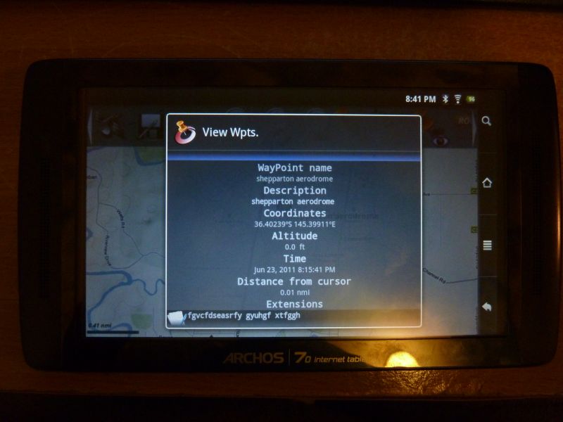
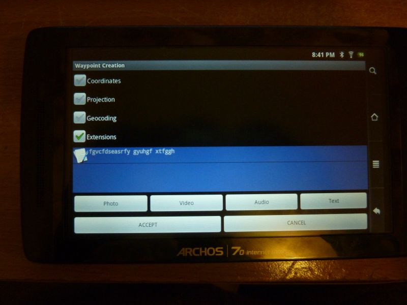
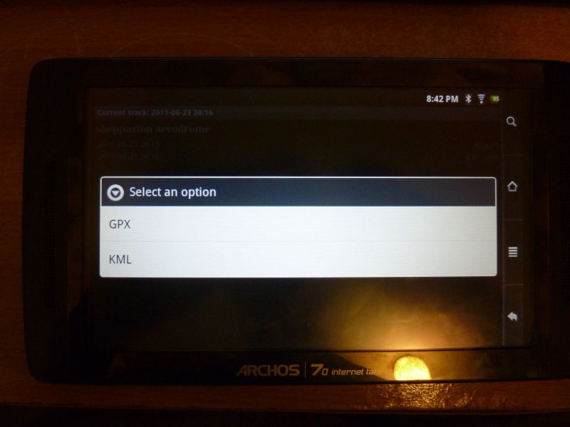
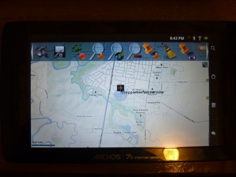
Ian/Gibbo, I had a chance to play with Oruxmaps for android. It has the facility to include details for waypoints - including adding photos, text file, video and audio files. The waypoints can be exported/imported as GPX/KML files. Ian I will upload your files and see how it goes and let you guys know sometime tomorrow. Cheers, -
Google Earth as a moving map engine..
pradeep replied to Gibbo's topic in Instruments, Radios and Electronics
Thanks for that Gibbo.... Actually I had two concerns regarding this 1. copyright issues with google, by publicly hosting works derived from its products, on this site, 2. IF we go for industry acceptance the issue related to that, by the look of it, those two concerns has already been solved by your previous posts, so my concerns are resolved....:clap2: Ian, I had a look at the file, it is sort of the data I was expecting the users to fill out. But I doubt how many of them will actually download the file, update it and upload it. Is there a way to set up a database system - like a sql system - which is tied with a web page ´front end´ so users can update aerodrome details just by logging into this website. These are some of the additional data we can add: 1. CTAF 2. Fuel type/availability 3. Contact details 4. Facilities available (toilet..) 5. Maintaining authority (Council..) 6. Type of aerodrome (reg...) .... regards, -
Google Earth as a moving map engine..
pradeep replied to Gibbo's topic in Instruments, Radios and Electronics
Ian, I am currently working on converting the Geo Sciences maps to useable format. I am still using OziExplorer and similar products for GPS purposes. I haven't use the google earth yest but will give it a go. By Gibbo's explanation i think this will be a cheap and easy option for us, but my question to all is do we have any plans to apply for industry recognition in future, if so I doubt the acceptability of google earth as the base data for maps. But if our plans are for a GPS with basic information, as a secondary tool, then i think Gibbo's method is the way to go as it has already been tested by Gibbo. It is all a matter of polishing things up. I think Gibbo's spot on with this, as one our goals is to include details of as much aerodromes as possible. A Wiki page with downloadable links for user managed file types would be good, I think. Ian, I also think whether we make a list of TO DO things so we all are informed of the expected outcomes of our project. cheers, -
Google Earth as a moving map engine..
pradeep replied to Gibbo's topic in Instruments, Radios and Electronics
Looks promising Gibbo, Do we have any restriction (in regards to google) on the distribution of such system for free/non-profit purposes. I don't think the amount of data would be an issue in this fast internet age. Cheers, -
These are the photos of my Archos 70IT / GPS and charger still 'under test' mode. Cheers,
-
When I used my Mio Moov 370, I found that the internal RAM installation was more stable than the SDcard installation. I put the startup selection screen option on miopocket, with timeout default to miopocket and option to start original nav program if required. This way I can use any nav program to suit the situation. cheers,
-
Not exactly sure about the GPS though. I have a colleague who is having a T-Tab, to me it is useless - lag on touch response, slow processor, etc. If you are buying a resistive touch tab, I would highly recommend you to have a look at a capacitive touch screen before decide which way to go. I always have the mantra 'If you can't use it for the purpose you bought, then doesn't matter how cheap it is, it is a waste of money'. But hey, it's only me.... Cheers,
-
Tried Androzic on road with some of my maps, works great. Still not decided between Orux maps and Androzic Now with the Antiglare screen protector the screen is much better than before. I also had to build a circuit (using the LM2576 ic) to charge my Archos from car as none of the branded car chargers were rated for 2A, although some of the cheapo states 2.1A for iPad, two of them I bought were making a whinning noise and considerable heat when charging the Archos 70. I will post some photos on this soon. cheers,
-
Changes once you got the license (Certificate)
pradeep replied to pradeep's topic in AUS/NZ General Discussion
At one stage whenever I booked for my lessons it was always crosswind, I was a bit dissapointed that I was not getting any solo for a long time as my instructor wanted me to experience all sorts of xwinds. One day the headwind on main rw was around 13knots and he took me to land on the cross strip to get the most out of the xwind technique. Once I landed he mentioned he really didn't want to touch the controls and I did a good job, that's when the enjoyment felt. cheers, -
Has anyone had any experience like once you got the license your flying skills changed, either improved or degrade? (no one is watching you anymore....) I am referring to flights soon after getting the license (say first 5 flights). cheers,