

DWF
-
Posts
486 -
Joined
-
Last visited
-
Days Won
3
Content Type
Profiles
Forums
Gallery
Downloads
Blogs
Events
Store
Aircraft
Resources
Tutorials
Articles
Classifieds
Movies
Books
Community Map
Quizzes
Videos Directory
Posts posted by DWF
-
-
Please forgive my return to the trailer [off] topic

but those of you who are interested in such matters may also find this interesting and a case in point:
kelmscott-fatal-crash-after-multiple-vehicles-towed
-
What are the Trophies?
How are they acquired?
-
IT'S A MIRACLE .......... (they ever flew).
-
It works for me like it is.
-
 1
1
-
 2
2
-
-
dd/mm/yyyy is the conventional way of writing dates (unless you are from USA where they do things differentlySo why year first? .....) and our human brains have come to accept it as the norm (or the way it should be), however ....With the age of computers, databases and other records the best way to access a particular instant is to work from large to small:
first you have the year - eg 2016
then the month - eg 08
then the day - eg 29
and you can then continue to the hour 18 (24 hour clock)
and the minute 16
and even to the second 35
and you get a unique and precise instant of 20160829 181635
It can take a little while to get your head around it but computers love it!
Next time you look at a NOTAM (what's that you ask?) or a met report or forecast have a look at the date/time group they are always in the format yyyymmddhhmm - sometimes with yyyy or minutes left off but it is always the same sequence.
I am not asking you to like it but that is the way it is.
Does that help?
-
-
If you do that for 19xx but not for 20xx you will confuse the system as all the 19xx entries will be perceived as 2019.Then you include the 19 but otherwise.....Use yyyy in all cases to avoid this confusion.
YYMMDD = 160829 might get confused with post number, ........If you use yyyymmdd it is going to take quite a while before post numbers get close enough to be confused with dates.
-
-
Using a high wing aircraft can reduce or eliminate the overheating problem.
CAUTION: Overheating can also cause a pilot to shut down.
[Not a problem here at the moment - overcast, windy, light showers and 14 deg!]
-
1
-
-
Only for another 84 yearsIf we are reporting accidents, I think YYMMDD should suffice. 20 is a given now.And how about if you want to indicate an event last century?
-
The best format for date for ease of searching and computer/database listing is yyyymmdd - year month day.
-
Actually Kaz, to be a bit pedantic, your statement for YPLC should have been "All circuits to the EAST."..... In the example cited the original post, circuits would all be to the south. KazERSA calls for RWY 33 to be RH but a circuit to the south on that runway would be LH.
DWF
-
How does the "weight move forward on the aerofoil" by changing the AoA?.... At high aa the weight moves forward on the aerofoil ....The Cessna Cardinals have slots in the all-flying tailplane to prevent the it stalling, particularly on round-out for landing.
-
1
-
-
Perhaps he was a bit 'T'ed off......I once flew into Popham from the Isle of Wight and landed into the wind. The airfield manager came out & threw a wobbly because I'd landed against the tee. . .I hope you told him to 'F' off.
-
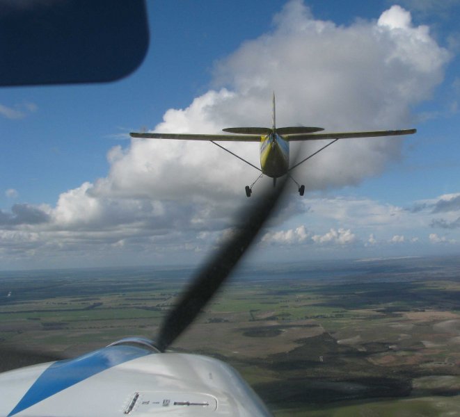
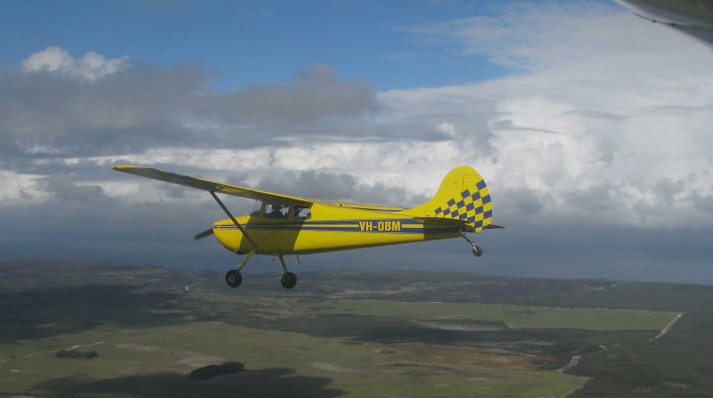
Out flying in the Brumby with a friend on a nice July morning enroute Munglinup to Myrup (YMYU).
Actually we were running ahead of an approaching cold front about 10mn behind!
Echelon Right
Line Astern
Echelon Right
-
5
-
-
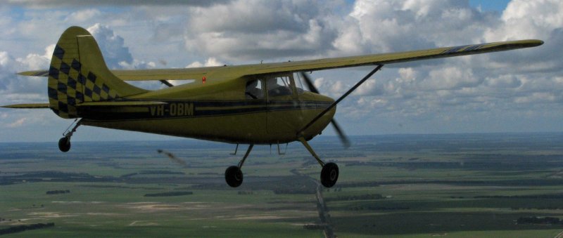
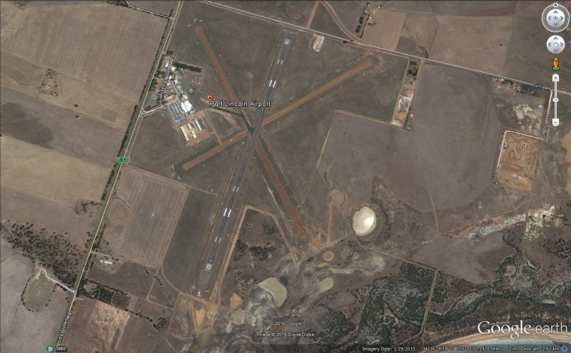
At Port Lincoln SA the arrows are at the end of the runway and only indicate that there is a RH circuit on a particular runway.
The RH circuit indicators are at BOTH ends of the runway.
This is not how it is described in the book and seems to be a non-standard use of the markers.
There are no markers near the windsock!
The ones for the gravel runways are a bit difficult to see.
DWF
-
See the diagram in post #4 above.I haven't seen the diagram. However at Palmyra airfield up my way all downwinds are the western side of the 36/18 runway because it is located very close to the controlled airspace of Mackay. Therefore any wide downwind to the east would be in controlled airspace.The 'normal' circuit direction is LH, however there are quite a few airports that have a RH circuit specified; usually to keep aircraft clear of terrain, airspace or noise sensitive areas. In some cases the circuit direction is different for day and night ops.
-
Has anyone seen this ground signal in use at any airport in Australia? I haven't, and I have been to a fair few of them.
-
I don't use the 'NEW' button. I just click on any item in the topics in which I am interested that have the darker unread shading.
-
Areas considered for forced landing in order of preference:
Runways/airstrips (you would be surprised how many pilots don't look for/consider these)
Farm roads (usually clear and little/no traffic)
Beaches - ocean or lake (need to be careful here - tides, waves, soft sand, etc.)
Paddocks (preferably not ploughed or in crop - also avoid ones with stock if possible)
.... paddocks are not a good option in my area at the moment as they are mostly waterlogged
Public roads (look for wires, sign posts, traffic)
Soft bush (Ugh!)
Water (cold, wet, and with my luck - sharks).
DWF
-
1
-
-
What is a "compression test"?....., it was more of a compression test than a language skills test in my opinion,..... Did you mean a "comprehension test"? .... Or have I just failed the test? DWF
-
1
-
-
Works OK for me on my PC. Seems simple and clean but I don't use the other menu options much anyway.
-
1
-
 1
1
-
-
How about a ballistic system to jettison the canopy?
Or why not go the whole hog and install an ejection seat with canopy piercing projection.
-
Puts a whole new meaning on flying Downunder.
-
 5
5
-


Stoked as just passed pre solo exam
in Student Pilot & Further Learning
Posted
Don't relax yet!
At least 4 more to go.
But you will be a better person for it.