

Ironpot
-
Posts
174 -
Joined
-
Last visited
Content Type
Profiles
Forums
Gallery
Downloads
Blogs
Events
Store
Aircraft
Resources
Tutorials
Articles
Classifieds
Movies
Books
Community Map
Quizzes
Posts posted by Ironpot
-
-
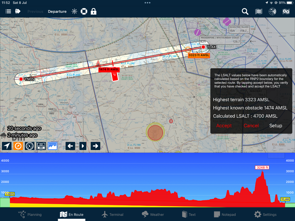
Apologies I didn’t want to cause a debate on LSALT.
Like everyone else, I try to learn something from these reports and take something a way that I can use, should I find myself in a similar situation.
My personal solution will not work for everybody and l’m not suggesting non-instrument rated pilots even think of using this! Climbing to grid LSALT was 5200 (10 nm Amberley would be better and that’s 3400) but this guy would still be in cloud, and copping flak from ATS but on Autopilot and safe. ATS would’ve had him on radar and vectored him to safety somewhere. That’s what they are there for.
I can’t imagine the shit he would’ve copped afterwards. But he was retiring 2 months later! Hey ho!-
 1
1
-
 1
1
-
 2
2
-
-
12 hours ago, turboplanner said:
LSALT is not important for VFR flying, because you can only fly where you can see the mountaintops, although if you're going to be flying in mining areas, Tower locations can be important because they can be in the landing strip pattern or nearby and hard to see.
However in a lot of IMC crashes the non-qualified pilot was able to maintain control but died by flying directly into a mountain, building etc.
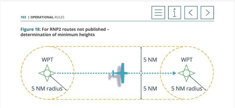
IMC pilots are required to identify Lowest Safe Altitude, not for the route on the screen, but for a path 5nm each side of the direct track, so you have to survey 10 nm of mountains x the route from point A to Point B and around each airport.
This drawing is from CASR Part 91 General Operating and Flight Rules, Plain English Guide starting at Page 102

It is important! I think you forgot NVFR!!!!
The illustration should be 10 miles left and right of track and it’s only applicable if you’re TSO’d GNSS equipped; otherwise you have to calculate lowest safe by reference to the aids available.In practice, I think this pilot would be aware of “Grid” LSALT as shown on the ERC (not the VFR) chart. So just switch to ERC on your iPad/tablet and the big blue number indicates the LSALT for the grid square that you’re situated.
-
2
-
-
Condolences to the families and apologies for any distress this discussion may cause but the Aviation community do need the discuss this accident.
2 hours ago, RFguy said:2nd paragraph
"The Cessna had departed from Dalby toward forecast en route weather unsuitable for visual flight, despite the pilot only being qualified for flight in visual conditions."
I stopped reading there...
That’s not the full story - he held a MECIR and had 8 renewals. He knew how to fly on instruments in an emergency. Furthermore the aircraft was IFR approved and had an autopilot. He had the latest TAFs and METARS and maybe somewhere abeam Toowoomba he knew it was time to climb to LSALT, talk to Amberley Approach and declare a problem.
Was this just a case of “ hold my beer”?
-
1
-
-
Council have voted to continue use and are actually going to spend some $s on maintenance
-
 1
1
-
-
17 minutes ago, kgwilson said:
So I fly in to Coffs without an ASIC, taxi to the Aero Club, go inside for a cuppa. Ask someone for the gate code, fly home. No problem with ATC or anyone else there but due to an ill conceived and enacted system that does not enhance safety in any way this is Illegal?
Expensive cup of coffee!
But, in the real world, and say you were flying a real flight - if you had left the airport, just how would you have flown away, had you, let’s say, left the confines of the airport?
-
1
-
-
40 minutes ago, skippydiesel said:
Just one of several examples: I fly into a north western NSW country ADSCA/ASIC airport, tie my aircraft down in the designated visitor area and then spend 45 minutes failing to find anyone at all, let alone a security person. Exit via unsecured "security" gate - hungry & tired, I get a taxi into town spend the night, taxi back to airport - still not a sole in sight - preflight/depart. Good experience despite the lack of a chat with fellow aviator/security guard/maintenance person/etc.
Which airport is that?
-
Mods, this is getting a bit silly now!
We all know that young students and the general public (maybe CASA too) read these forums and rely on, what they hope, is genuine experience. We all know that pilots require a valid background but that is not being conveyed here.
We now have a poster encouraging pilots to break Australian Federal Law by walking through hangars and avoiding security fences without the appropriate security clearance - clearly this forum, at the vey least, cannot support any such cowboy behaviour amongst pilots. At the worst, in the event of a safety incident, the forum may have some liability and clearly these views should not be condoned.
-
1
-
 1
1
-
-
2 hours ago, facthunter said:
Becoming a bit of a "what if " IF you want more certainty, get in touch Prior. Nev
Sure, ring ahead if you are enquiring about fuel. But I don’t know of an ARO that will give you the gate code without seeing your ASIC. They might just say it’s the CTAF if it is … maybe?
My point is that, more than likely, your security for your very valuable “pride & joy” relies on an ARO doing his job properly whilst you are away. They shouldn’t be allowing anyone on a Security Controlled airfield without an ASIC. It’s a form of security for your aircraft and pretty cost effective when you think about it.
We have one guy on here from Longreach - last time I was in Longreach I had to hold my ASIC up to the camera BEFORE I could LEAVE through the gate and I was bursting for a piss! The ARO is sat in his office 50 yards away!
We have another guy on here from Mackay - the ARO there is next to the door of the aircraft as soon as you shut down (Brandon?) Lovely guy, and he wants to see your ASIC straightaway. Then he gives you a card with the current code in exchange.
So, if you just want to do circuits around your home paddock then you certainly don’t need an ASIC. But if you want to fly somewhere where you can wander into town and then you have to get back through the gate on your return, then you do need an ASIC. The batshit crazy, MAGA type sovereign citizens raving on here probably don’t fly in the real world so pay no attention to them.
-
Sure sure and you probably tie the aircraft down too.
But do you never make contact with the ARO when you park-up up at an airfield? Do you just walk out the gate without talking to anyone?
If so how do you get the gate code if it’s not displayed?
-
On 15/11/2023 at 6:46 PM, Roscoe said:
My issue is the private pilot who lands and just wants to go into town to support the community!
Serious question: when you park up at an airfield and before you head into town, say Bundaberg for example, exactly how do you secure your aircraft?
-
My 2 bobs on this one:
It’s really handy to see traffic on the iPad and cos the 2 systems don’t share data its something else to decide upon.
It appears to me that QzRunways is most popular amongst the amateur community, i.e. RAA, smaller GA etc. Avplan seems to be standard issue amongst the RPT, RFDS and bigger GA guys. It may simply be a cost thing but because the 2 EFBs only show their own subscriber traffic you don’t see the other guys on the display! I understand Avplan have offered to share but OzRunways have refused to do so.
So, maybe, if you normally fly VFR below 4500, you might see more on OzRunways but if you generally fly IFR or cross-country then Avplan might be better for you.
In a bid to keep everything as simple as possible, all my gear is now Apple cos it talks to each other and it just works straight out of the box. I use a standard iPad, 32 Gb (no card) a mini, 64 Gb, as a backup (again no card). An iPhone serves as a hotspot in the air - I generally use an Optus connection but have access to a Telstra one if I'm heading outside the J curve. A Garmin Glo provides GPS signal.
I fancy an iPad pro next. I find the mini is just too small and awkward for general use (it’s great as a backup and I’ve needed to use it in anger 2ce - the iPad will overheat if you leave it charging in the sun.
-
UK Military always taught that QNH is Q “Newlyn Harbour”.
( Newlyn Harbour is where zero sea level is calculated from for the UK based on the observations taken there for many years)QFE is Q Field Elevation
-
1
-
1
-
-
TWR ATS NOT AVBL DUE OPR RESTRICTIONS
ARCHERFIELD CLASS D AIRSPACE 1500FT AND BLW BECOMES CLASS G AIRPSACE
AS PER EN ROUTE
SUPPLEMENT AUSTRALIA (ERSA) YBAF - ATS AIRSPACE - OUTSIDE TWR HR
COMMON TRAFFIC ADVISORY FREQUENCY (CTAF) 118.1 MHZ
FROM 09 282300 TO 09 290700
2309282300 TO 2309290000
2309290200 TO 2309290300
2309290500 TO 2309290545
2309290630 TO 2309290700Archerfield has ATS closures over the next few days. Check NOTAMs is a must.
-
You’ll be fine at a weekend. The RAF never work weekends!
just talk to BN CN 121.2 when you depart Dalby (on the ground if you wish) - let them know your intentions and they will tell if you need to talk to Approach should the area be active. Stay on freq and they’ll guide you right up to Somerset Dam.
Caboolture is something else !

-
This came up recently when I was having a chat with some survey guys - they’re flying for up to 6 hours at a time.
They using vomit bags from the chemist. $5 for 5 . Waterproof/twist& lock/disposable etc
-
4
-
3
-
-
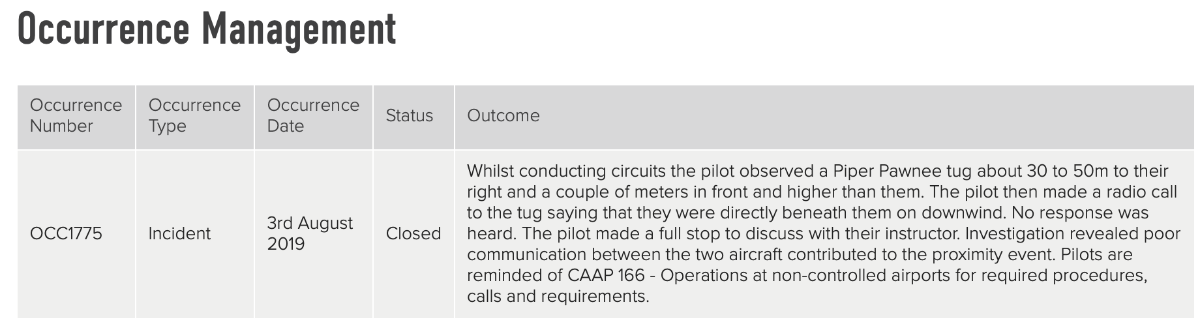
On 18/6/2022 at 9:35 AM, APenNameAndThatA said:
A couple of years ago, I was involved in an incident at Caboolture. I sent RA-Aus a written statement. Later, *without them ever speaking to me at all*, the following turned up in my account when I logged in one day, the following appeared,
"Whilst conducting circuits the pilot observed a Piper Pawnee tug about 30 to 50 m to their right and then a couple of meters in front and higher than them. The pilot then made a radio call to the tug saying that they were directly beneath them on downwind. No response was heard. The pilot made a full stop to discuss with their instructor. Investigation revealed poor communication between the two aircraft contributed to the proximity event. Pilots are reminded of CAAP 166 - Operators at non-controlled airports for required procedures, calls and requirements."
After I discussed the matter with them, RA-Aus changed the occurrence report to the following.
"Whilst downwind the pilot observed a Piper Pawnee tow plane above them. The pilot then made a radio call to the tug saying that they were directly beneath them on downwind. No response was heard. The pilot made a full stop to discuss with their instructor. Review of this occurrence indicated that both pilots reported to make radio calls, however it is unknown why two-way communication was not established. The pilot of the tow plane was briefed to ensure they continue to see and avoid other aircraft when operating."
I was prompted to post this because someone on this forum (quite reasonably) posted that a technical person at RA-Aus said that people did not tell RA-Aus about human factors things so it was hard for RA-Aus to deal with them (or words to that effect). My point is that, when it comes to incident investigation, RA-Aus is pure amateur hour. A while ago I think I posted that there had been a year with fewer than average accidents and RA-Aus said in one of their emails how safe how safe flying was. IIRC, I emailed them back to let them know that about random being more irregular than people think and about regression to them mean. They emailed me to say that they would "engage with" me. I left them to it.
Following the tragedy at YCAB, I had to just check my memory of this post. Turns out that it was more poignant than I remembered.
Condolences to all concerned.-
3
-
2
-
-
CASA are holding a webinar today: maybe of interest?
Might be too late to register? -
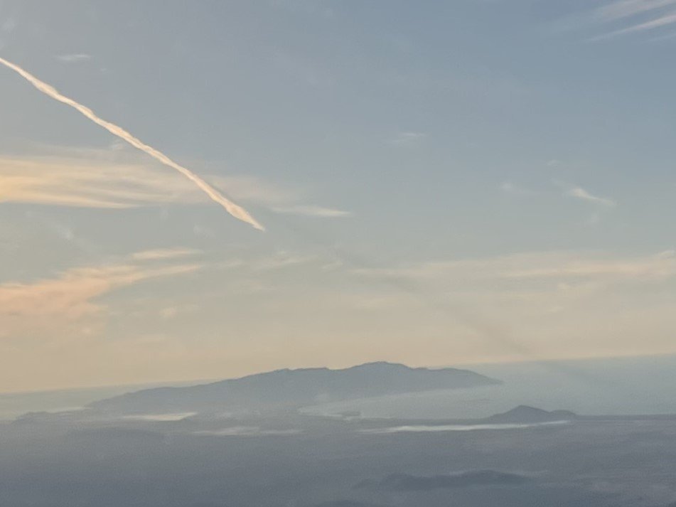
11 minutes ago, Blueadventures said:
I believe it was a large missile of some sort, earlier on was very distant smoke trail down low and vapour higher, seemed so close I was looking for a warship off the coast. Was a while before I thought to take image and it was dissipating a lot. I even turned to port to put the smoke trail viewing through my side window. I have tried to edit the image for better contrast. Can see it was much closer than the horizon, There is a full military aviation base at Bowen Airport and a notice was out that effect. Very interesting.
I know it’s not your sighting but ATS said, on area frequency, that the big flash on Saturday night was an Indian rocket stage separation and was visible along the east coast.
-
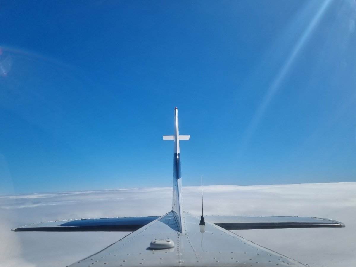
Rear seat passenger took this - made I larf!
-
1
-
1
-
-
Here ya go:
I did the last one. I can thoroughly recommend it if you have time. It’s good to hear their version of events too.
-
Simply wasn’t a good day for scud running/VFR :
-
2
-
1
-
-
This is such a sad one. Clearly many families impacted by it and it could have been far worse.
I might be naive but I honestly thought we had seen the last of unqualified/unendorsed pilots without medicals and guys operating aircraft without MRs, insurance etc. many years ago.
If something similar was attempted in any road vehicle I’m sure that the boys In blue would be onto it in a flash. Other than some cross border enquiries during the Covid period, I have never seen any pilot have their bona fides checked.
Surely somebody knew what was occurring with this lad and understood where it could lead. The ATSB have washed their hands of it now and it’s too late for them to comment further but should they have suggested that steps could be taken to help it from occurring again?
-
I understand that very few RPTs have ADSB in.
-
16 minutes ago, RFguy said:
but, ATC provides separation for IFR and VFR traffic for IFR traffic , that's their job (putting aside if all the planes had been equipped, then the two planes could have alerted their pilots without ATC)
Correct.
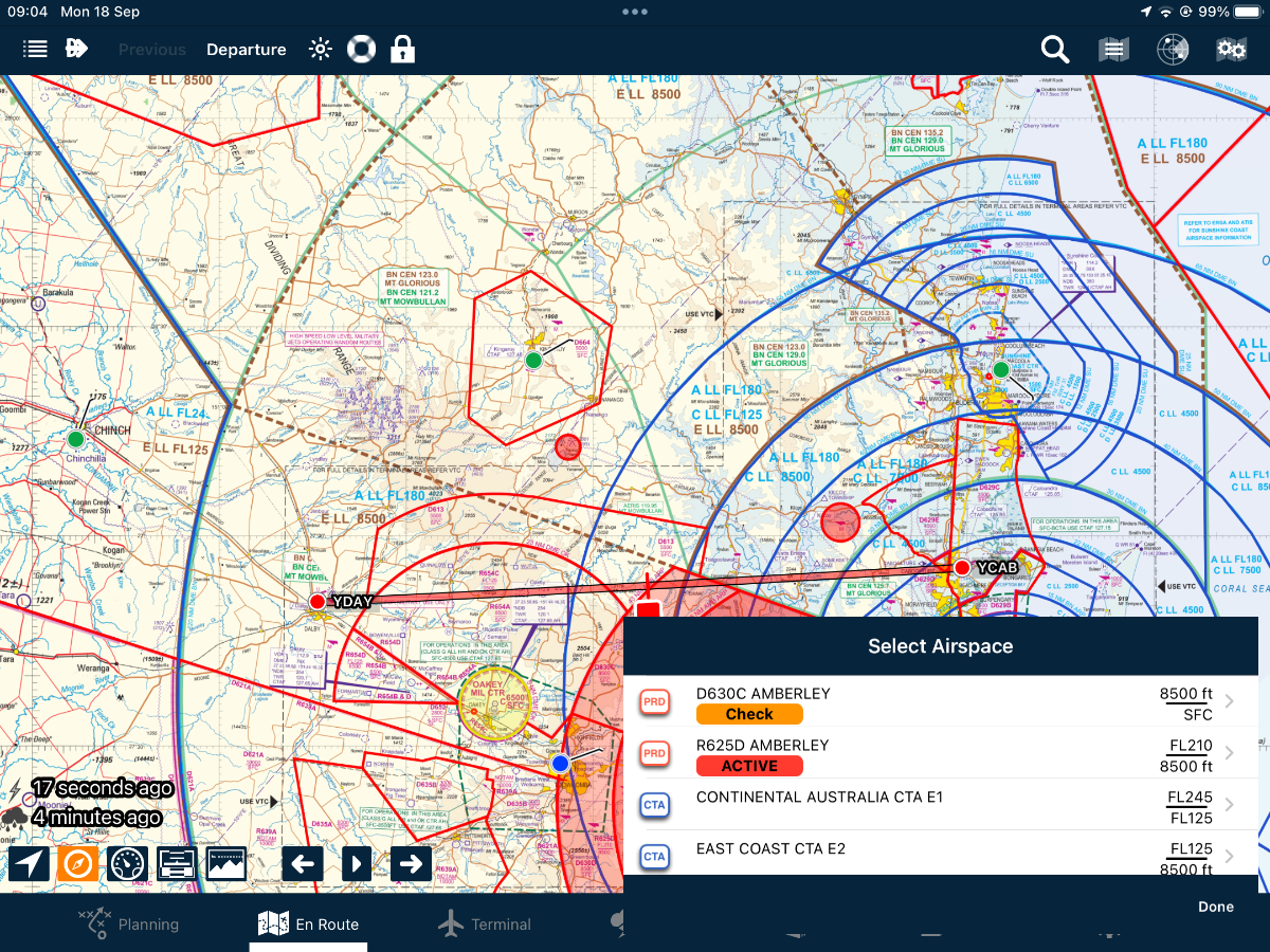
ATC alerted the IFR aircraft, they requested and were cleared “up to 5 miles left of track” ; announced he could see R75** on the ADSB and once they were abeam of R75** they simply tracked to rejoin planned route.
ATC were using radar.
edit.jpg.d1892394bd81da5eae0a2f67bbf06ac6.jpg)
ATSB report on Cessna 182 crash Qld 29 Aug 2022.
in Aircraft Incidents and Accidents
Posted
No it wasn’t me.
Could you edit that one please.