dlps73
-
Posts
188 -
Joined
-
Last visited
Content Type
Profiles
Forums
Gallery
Downloads
Blogs
Events
Store
Aircraft
Resources
Tutorials
Articles
Classifieds
Movies
Books
Community Map
Quizzes
Videos Directory
Everything posted by dlps73
-
OK Aussie Steve - Your mission, should you decide to accept it, is to determine whether, as Dave suspects, it's the work of aliens (I think we'll forget the Bantam strip bit - Katoomba's a bit to high for Bantams even the chicken type :) ) or as I suspect it's a cunning plot to grow dope (note the clever use of the word plot which can denote a scheme or an area of ground to grow things on - who said ultralight pilots are dumber than GA pilots - actually my brother in law but he's a muppet that flies Pitts Specials so it doesn't count)...... Cheers.........Doug
-
That's amazing Ross - you could see the Wind Farm from miles away - it certainly gave the impression the land was flat. And you highlighted a major concern I have. Height really does flatten the landscape which would scare me if I ever had an engine failure because Murphy's Law would dictate that what would look flat to me would be "alpine" by the time I was commited.... Cheers........Doug
-
See Darren those photos are a bit creepy - it's like you're being stalked from above! You should apply for an AVO - Aerial Violation Order.......:) Just joking John.......:big_grin: Cheers.........Doug
-
Thanks Doug - although I think Proper Pilot and Jabiru in the same sentence could be construed as either an oxymoron or a contradiction... Cheers .........Doug the Copy
-
Thank you all for your encouraging comments. Chris - This appears to be the standard test around the Oaks. Doug - Attemping to get my name changed by deedpoll. Yenn - Hit it right on the nail - first and foremost safe - then happy. Matt - Quite right - not allowed to use GPS whilst undergoing the test. Paul - Thank you for your kind words and Dave was thanked also. Adam - I did take away a lot of great learnings from that one exercise. And now I can report with a huge grin that I passed the last bit on Saturday. The trip was The Oaks - Mittagong - Wollongong - Wedderburn - The Oaks. We were primarily focussed on circuit pattern entry and they all went off without a hitch......I are now a proper pilot! :big_grin: Cheers.........Doug
-
Hi Darren, I pretty sure John was down the Oaks on Saturday but I didn't see him fly - possibly too windy. Maybe he needs your company for ballast......;) Cheers.......Doug
-
Hi Aussie Steve, Seeing as your up that neck of the woods, do you know what this is? We saw it last week and though maybe it was crop circles for spatially challenged people..... Cheers........Doug
-
Hi David, As my (Sky Ranger) kit is still on its way from France I would appreciate any further information you receive regarding these cable ends. Cheers.......Doug
-
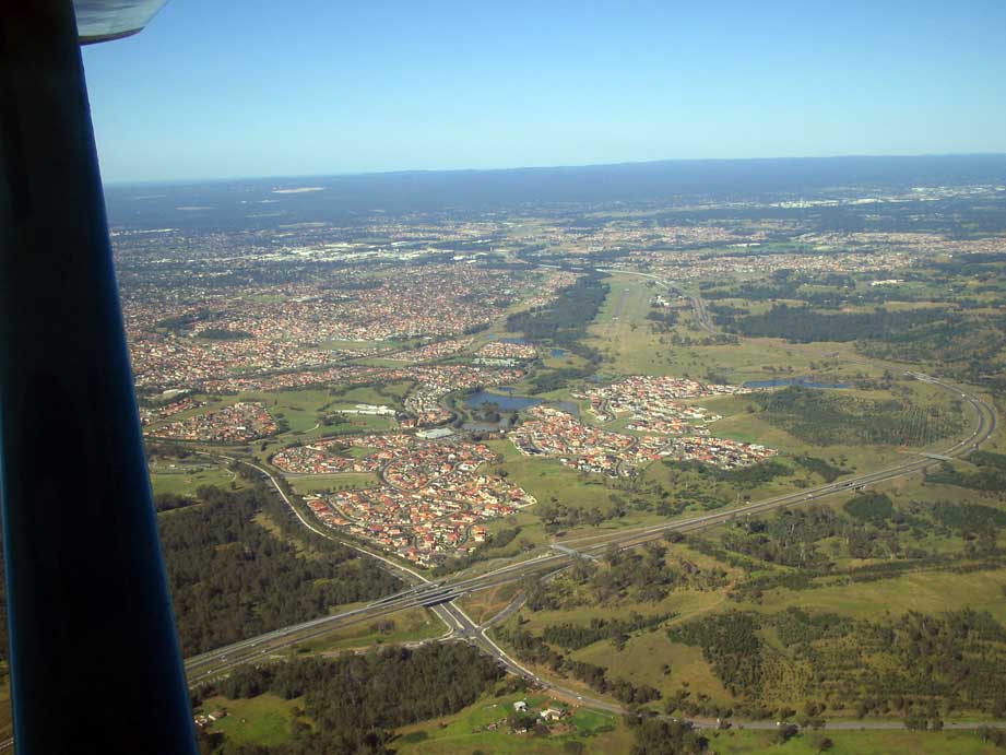
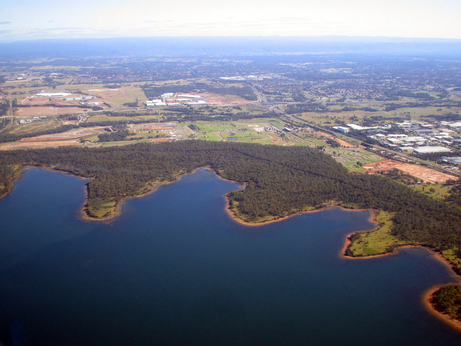
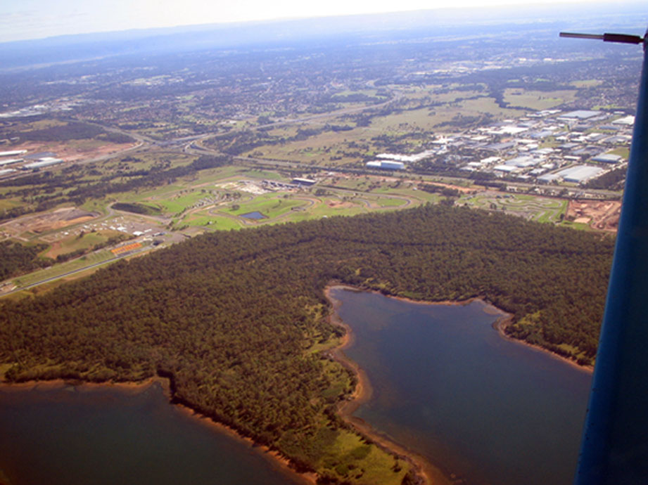
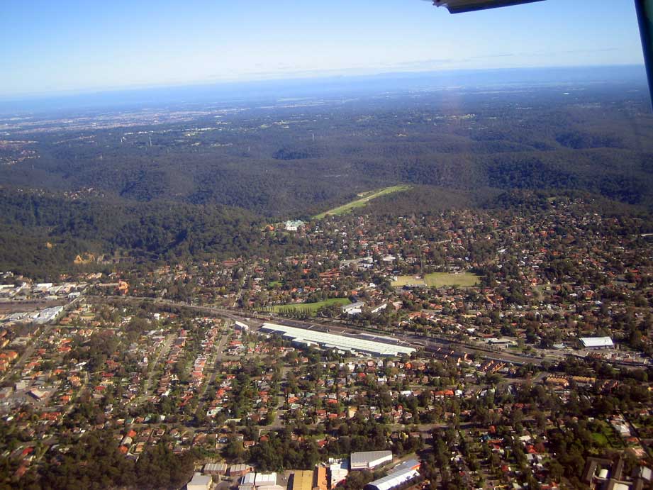
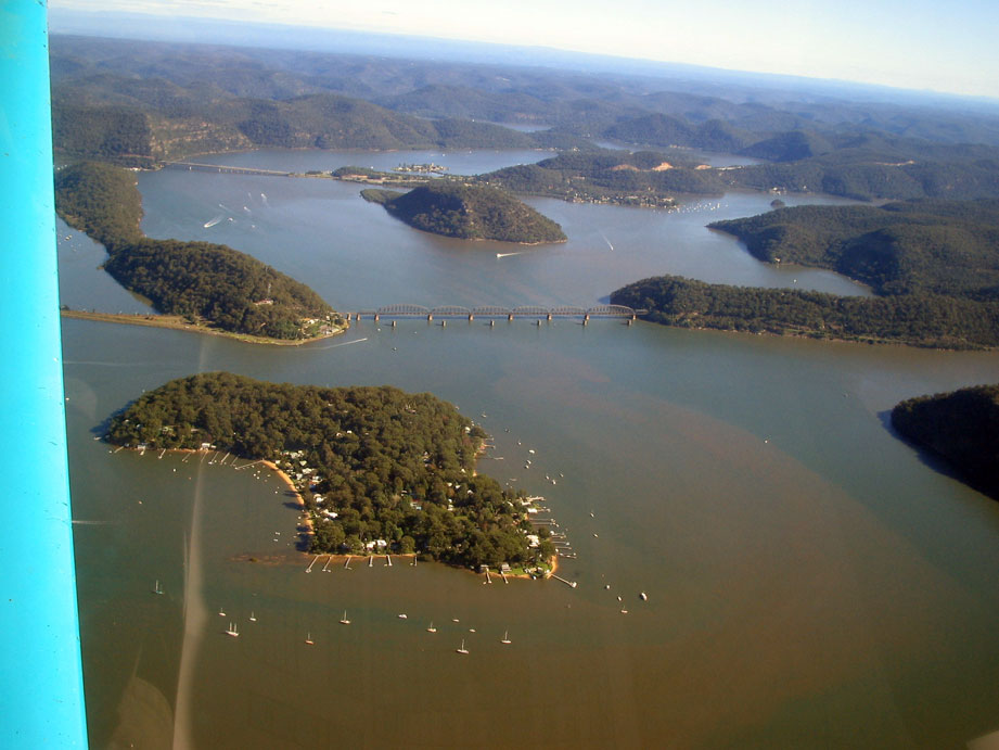
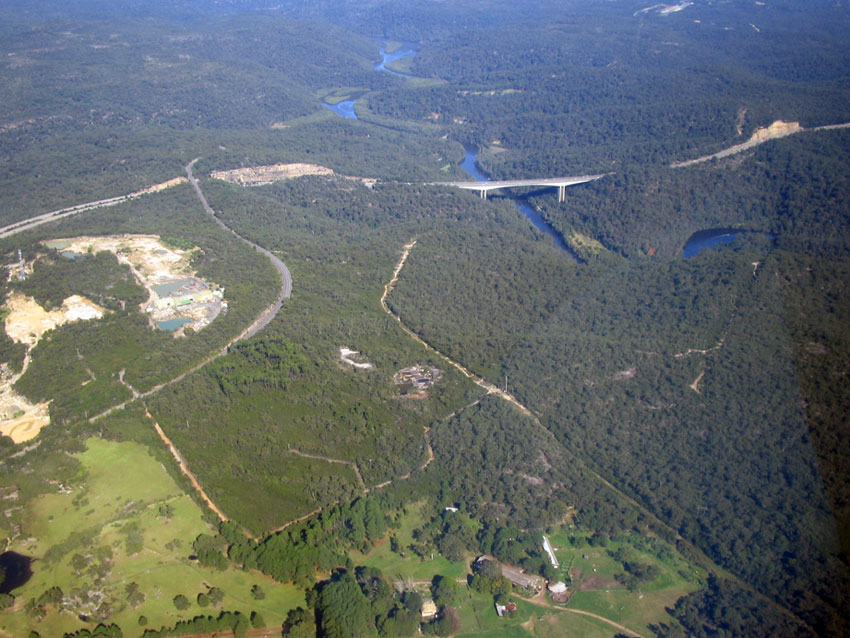
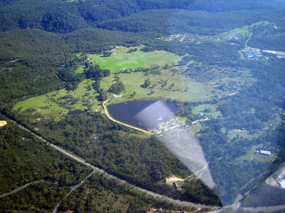
Sunday morning dawned bright and clear - unlike myself who was still suffering from a head cold and had bugger all sleep that night. At 8:30am Dave and I pulled the Plastic Parrot from her nest and got down to the serious business of pre-flighting. At 30am it was “Chocks Away!†and off we rolled on the first leg of our trip. As this was the test for my cross country endorsement I was more than prepared with enough charts to wall paper a large hanger, pens and pencils galore and sufficient rulers to over throw a small nation. The first leg was The Oaks to Mittagong, the problems began when we found it difficult to achieve 90KIAS – thankfully this was resolved half an hour later when we realised I had left the flaps on….. In my defence I raise the fact that I had now become a negative yardstick by which all others could be measured. Exhibit One Picture taken by Dave of the countryside with the flaps still deployed. As Dave’s primary task was to act as Official Photographer it was not encouraging when he would laugh and say: “I’m just taking a picture of where we’re supposed to be.†Nevertheless I arrived overhead at Mittagong Airfield at roughly the time I was supposed to be there, within a day any rate – can’t get to fanatical about that sort of thing - and I had actually found it, my confidence was building again. Mittagong Airfield Mittagong to Crookwell was a doddle with the Wind Farm sticking out like up right poles in a flat landscape – which they were. Wind Farm Crookwell Airfield Crookwell to Young – what’s that all about? Absolutely featureless, irrespective I held the calculated bearing and resolutely flew on. It was only when we finally flew round the mountain that obscured the city that I realised my track was a wee smidgin off. A quick bank and a few minutes later Young Airfield could be crossed off the Flight Plan. Three down, six to go. Young Airfield Our next leg, Young to Cowra, was relatively plane sailing (ßnote pun). Essentially just follow the road and railway – how hard is that? We even did a pretend circuit, fortunately it was pretend as I misread the windsock and we were actually landing downwind…sigh. Cowra to Orange was where it all became unravelled. I aligned the DG to the compass, turned the aircraft to the required bearing, noted a feature in the distance to align with and off we went. The first landmark I scanned for was a small town called Woodstock with Werribee Airfield to the North of it. These were supposed to be to the right of the aircraft – the GPS track indicates that we flew directly over them. I never actually saw either one. Obvious to everyone except me, I was being blown steadily off track. As the time arrived when I should be over Orange airfield I realised I was hopelessly lost. In desperation I noted a largish town to the right and turned towards it thinking “Orange!†The comments from Dave were as follows: “Let’s see you have been steadily drifting to the right off course which would logically see you well to the right of the planned track yet now you’re lost you’re turning to the right – it appears your three years apprenticeship under the Village Idiot is finally bearing fruit!†As soon as I turned to the left I saw the reservoir that lies to the east of Orange and meekly headed towards it. To add insult to injury I turned the wrong way after overflying the airfield and we had to repeat the exercise – oh the humility…. Orange Airfield We landed at Orange to refuel both the aircraft and ourselves and after consuming a couple of muesli bars and a fruit drink I was ready and raring to go. I had managed to forgive myself for the tracking error and attempting a right hand circuit – and let’s face it, my cunning ploy to enable Dave to feel superior was working beyond my wildest dreams. With the Orange to Bathurst leg I actually felt I was cheating because you could practically see Bathurst as soon as you reached circuit height! Dave opined that we should really do another approach and pretend landing at Bathurst to ensure I had learnt from my mistake at Orange. The simplicity of the navigational side allowed me to focus on my pattern entry which was tragic to say the least. I envisioned a variety of airfield entry points and the correct method to allow us to join the circuit safely. Confidence renewed as I approached the airfield I checked the windsock, determined the direction for landing, repeated my mantra “I will not turn to the right.†Overflew the runway and promptly turned to the right. The scream from Dave was high pitched enough to shatter glass. Suddenly I was consumed with jealousy for Kamikaze pilots – at least they didn’t have to come back and land. I had absolutely no excuse – I had played the Idiot card at Orange which was my last trump. It slowly dawned on me that whilst I could land at Bankstown, one of the busiest airfields in Australia, I was total crap at any other if I had to think and plan. I accepted the fact that I was not going to get through the test at this time, which was kind off sad but definitely expensive. I was also quite taken aback as I had though I had covered all the necessary requirements only to realise that something so basic had brought me undone. Katoomba Airfield The rest of the trip was relatively straight forward; it’s hard to be depressed when given the magic of flying. Dave busied himself taking a series of photos of Warragamba dam whilst progressively tilting the camera making it look as if the Plastic Parrot was looping – fat chance. From Glenbrook to The Oaks I was again blown off course but just turned right when the ETA was reached and subsequently located the airfield. At least I had learnt that lesson! In summation, given the fact that I had managed to navigate nearly 700km from The Oaks and back with a map, compass, ruler, protractor and watch and screwed up just the once I actually felt pretty good about that part of the exercise. One of my main fears had always been getting lost. When it eventuates, my normal flying will be with map, compass and watch with GPS as back-up. Dave has demanded a mini navex focusing on airfield and circuit entry procedures before he will sign me off. I’ve also promised him we’ll do another navex using my aircraft as soon as it’s built and certified. In conclusion I believe you can teach an old Doug new tricks…… GPS Track Cheers.........Doug
-
According to the Sydney Daily Telegraph today Police aircraft (in certain circumstances) will now be allowed to fly with their navigation lights switched off. Extrapolating on that - is the aircraft following you in the circuit a normal GA/Ultralight or is it actually an unmarked police aircraft! Flying Booze Buses? Exceeding the downwind speed limit? Flying over a school zone in restricted hours? Sorry.....medication hasn't kicked in yet. Cheers.......Doug
-
Damn! There's never a turkey around when you need one......;)
-
Heads up guys and gals...... ABC TV this Thursday 8:30pm Start of a three part series called Air Australia. This weeks title "Canvas and Sticks" Not sure if it's about ultralights (the aircraft not our forum member ) but its got to beat big Brother! Cheers..........Doug
-
Great shots Paul - could have taken the last 3 in B&W! Cheers.......Doug
-
SP - I'll try Google Earth again! Darren - We came in just as you guys were pulling the trike out. I had a quick cuppa with Dave and then shot through to get some lunch. Was going to stop and say hello but was over ruled by my stomach...:big_grin: Trip time was 1.7 and Dave took the majority of the photos so can claim no credit there except for a bit of Photoshop work. You'll have to instruct me on how to get them to load full page instead of thumbnails. Dave C - Thanks for the encouragement and I'll no doubt meet you and Darren and all of the Oaks Flyers in due course....;) Cheers.........Doug
-
Thanks Paul - I only had the frequencies listed in the green "clouds" on the VNC. Makes sense to list the ATIS and Flight Watch as weather is a concern (from my perspective) - More good info.... :big_grin: Cheers........Doug
-
Mike - Sound advice regarding re-testing every 6 months. Something I will now subscribe to. Cheers........Doug
-
JM - I have limited time with my Instructor and I won't be able to see him before the test this week. I've also been taught to source every knowledge base I can for answers and the depth of knowledge and wisdom here surpasses anything else. I certainly don't think I'm showing disrespect in canvassing other opinions and I also recognise the importance of this final test which is why I'm approaching it by covering all my bases. Ian, David, Chris and Darren - thank you for your positive contributions. I'll probably add a clip board to my list to allow in flight map drawing for diversions. I think Dave's planning to stop at Orange for re-fueling - this was raised in the discussion last Sunday. I have been getting the ARFOR for 20 and 21 in previous Navex's so I'm comfortable with that bit. The weather and SARTIME were two aspects that I thought could be a factor - hence the queries. Again - thanks guys - you've raised my confidence levels a lot. If all goes well I'll get Dave to take some photos along the way and (hopefully) do a trip report on Monday........:) Cheers.........Doug
-
This Sunday (weather permitting) I've got my final Navex. Route planned is The Oaks - Mittagong - Crookwell - Young - Cowra - Orange - Bathurst - Katoomba - Glenbrook - The Oaks. Question 1 - Is it normal to throw a diversion in? Question 2 - Maps - I'll be carrying Sydney VTC, Sydney VNC, Newcastle VNC and Sydney WAC and ERSA - have I forgotten any? Question 3 - Thanks to the advice given previously, I've been busy as a beaver using my whiz wheel, protractor etc - anything else I should practice? Question 4 - Do I need to concern myself about SARTIME reporting? Question 5 - Is it standard practice to update the weather enroute and if so - how? Thanks for reading.........Doug
-
Robbo - I checked the co-ordinates (I think it's the 3 tanks together, 1 big 2 little?) and there's no sign of any arrow in Google Earth...... Maybe they thought it was graffiti and painted over it..... Cheers........Doug
-
Ultralights - I've just had a quick look in Google Earth and can't locate it - do you have co-ordinates?
-
Ultralights - Only focused on the flashing lights that guide you in and out so didn't see it but from my GA days seem to remember it had a kink in it? Cheers.........Doug
-
This Navex was to re-enforce the discipline required transiting the Light Aircraft Lane that runs from Parramatta to the Hawksbury river. We boarded the Plastic Parrot at 30am yesterday and flew off into the not so wild blue yonder. Whilst my navigational skills have improved my radio skills are bordering on the pathetic (I was Jabiru 3190 for those who were unfortunate enough to be on frequency at the time). Cheers.........Doug Hoxton Park [ATTACH]2082[/ATTACH] Prospect Reservoir [ATTACH]2083[/ATTACH] Eastern Creek [ATTACH]2084[/ATTACH] Hornsby Railway Sheds [ATTACH]2085[/ATTACH] Hawksbury Railway Bridge [ATTACH]2086[/ATTACH] Bridge [ATTACH]2087[/ATTACH] Old Sydney Town [ATTACH]2088[/ATTACH]

-
Thanks Matt and Mike - in summation I believe the common theme is to thoroughly understand the basics ie map reading, drawing tracks, etc. and this then will allow me a "fall back" position if the electronic gizzmos fail. This is all good as I can still use my "toys" further up the learning curve! And Matt - you're describing pretty much how I envisage my flying will proceed further up the track - no outright dependency on any one device and multiple redundancy. Mike - all my GPS's are Garmin and none have extra cards for maps. Not sure if that's relevent but I've never had a failure and that includes the Map60CS which is mounted on my push bike for geocaching and gets a fair hammering. I shall bow down to your expertise though as I only know a few aviators and never thought of asking them.....:big_grin: Thanks again guys - this is certainly a great source of information and learning..... Cheers.......Doug
-
Thanks for the response guys - I was actually referring to creating the flight plan at home prior to actually flying but I see where you're coming from! However - whilst I carry a whiz wheel I still prefer to do in flight calculations using a CX-2 with my PDA (with an E6B program) as a back up (sorry but it takes me forever to work out wind drift calculations on the whiz wheel). I suppose my point is that the technology is there and available - why not use it? I recognise there's a Murphy's Law element to all of this - ergo the PDA backup but personally my compentancy and confidence lies with keyboards and LCD screens. BTW Out of curiosity, has anyone ever had a GPS fail on them? Cheers........Doug
-
Can I just say that it speaks volumes when it actually departs in front of the toilets? Sorry Doug - awkward and ungainly spring to mind....:) Cheers.......Doug (See- I said we should have our own forum.....)