JayKay
-
Posts
106 -
Joined
-
Last visited
Content Type
Profiles
Forums
Gallery
Downloads
Blogs
Events
Store
Aircraft
Resources
Tutorials
Articles
Classifieds
Movies
Books
Community Map
Quizzes
Videos Directory
Everything posted by JayKay
-
I just had a quick look to see what other countries are doing re plain english weather. I came across this METAR/TAF Information Page on the National Climatic Data Center - US Department of Commerce METAR Home Page Quoting part of the text ... "The conversion to a plain language format for thousands of domestic and international observations that are generated each hour of the day is impractical and would easily overwhelm our meteorological communication circuits. However, having now standardized to a considerable extent does allow computer programs to expand the "code" into plain language. However, if you are getting plain language reports, it is because the service you subscribe to (DUATS, WSI, Pan Am data, etc.) is providing that for you." I then had a look at the "National Oceanic and Atmospheric Administration's National Weather Service" website ADDS - METARs Typed in KCOS and selected METARs, TAFs, and RAW Format and got this ... ============== KCOS 240554Z VRB03KT 10SM FEW085 18/04 A3040 RMK AO2 SLP208 T01830039 10278 20183 50013 KCOS 240520Z 2406/2506 VRB06KT P6SM SCT200 FM240900 VRB05KT P6SM FEW040 SCT200 FM241800 17012KT P6SM SCT080 SCT200 FM242200 20015KT P6SM VCTS SCT080CB BKN200 FM250200 10012KT P6SM SCT080 BKN200 ============== This time I selected "Translated" and got this ... ============== METAR text: KCOS 240554Z VRB03KT 10SM FEW085 18/04 A3040 RMK AO2 SLP208 T01830039 10278 20183 50013 Conditions at: KCOS (COLORADO SPRINGS, CO, US) observed 0554 UTC 24 June 2010 Temperature: 18.3°C (65°F) Dewpoint: 3.9°C (39°F) [RH = 38%] Pressure (altimeter): 30.40 inches Hg (1029.5 mb) [sea-level pressure: 1020.8 mb] Winds: variable direction winds at 3 MPH (3 knots; 1.6 m/s) Visibility: 10 or more miles (16+ km) Ceiling: at least 12,000 feet AGL Clouds: few clouds at 8500 feet AGL Weather: no significant weather observed at this time -------------------------------------------------------------------------------- Forecast for: KCOS (COLORADO SPRINGS, CO, US) Text: KCOS 240520Z 2406/2506 VRB06KT P6SM SCT200 Forecast period: 0600 to 0900 UTC 24 June 2010 Forecast type: FROM: standard forecast or significant change Winds: variable direction winds at 7 MPH (6 knots; 3.1 m/s) Visibility: 6 or more miles (10+ km) Clouds: scattered clouds at 20000 feet AGL Weather: no significant weather forecast for this period <snip> (sorry about the loss of format - check out the webpage to see how clear it looks) ============== All done by a government agency in the United States. I note that other government agencies are also providing this service in other countries. I think the precedent is set. Why aren't we doing it? I see no reason why the RAA couldn't purchase a translator and provide it as a service on their website. This way they own the code, control maintenance and quality of the product. Ianboag is not the first person to have written the translation software. A number of commercial packages are available for purchase and have been on the market for some time. Ianboag is the first person (to the best of my knowledge) who made his code freely available to the public. There is no reason why the RAA couldn't put out a tender for the job, make a selection and provide this service to everyone via their website. I believe this would be easily achieved as it has already been developed by an number of sources (and currently freely available). How about it RAA? Ian Baker, aren't you close to the RAA thinktank?
-
In 1983 the Australian government introduced the "Plain English and Simpler Forms Program". 27 years later we're still reading vital weather information in code. Who's not following the rules?
-
Cultural Shift from what to what? You can't just talk about safety and interpret the rules your own way to suit. I note that the law does not allow us to define our own 'safety standards' in a car. Why then should it allow us to define our own individual safety standards when in the air? My feeling is that we should fly safely WITHIN the rules. That's why we have to understand what they are in the first place. If we all 'fly safely' within our INDIVIDUAL interpretation of the rules there will be chaos in the air, as there would be chaos on the streets if we applied the same principle to driving. I'm by no means advocating the fact that 'the rules' are perfect. They clearly are not. But we should do our best to understand them and interpret them the same way so our actions in the air become more predictable to others and therefore safer.
-
The difference between the two is: ... (copied off the RAA website) World Aeronautical Charts: the 43 Australian WACs are very small scale (1:1 000 000), derived from aerial photography, and designed for pre-flight planning and pilotage. They are part of an ICAO international series. They do not indicate CTR or PRD, nor is there any FIA, radiocommunications or radionavigation information. As the reissue frequency is 3–5 years the base can be substantially out of date, particularly in regard to the road/rail/power transmission line infrastructure. Amendment lists for each edition are published in AIP SUP but these amendments generally relate to location of airstrips and special activities rather than topography or infrastructure. Each WAC generally covers 6° of longitude and 4° of latitude. Sheet dimensions are about 70 × 60 cm and the scale is such that a real distance of one nautical mile is represented by less than 2 mm on the chart; thus WACs are really not suited to low-altitude navigation in slow aircraft. Visual Navigation Charts: the VNCs are a larger scale at 1:500 000 and show airspace information and FIS detail over the topographic base. They are reissued at six-monthly intervals but the base topographic detail may not be up to date. They are far superior to the WACs for both flight planning and pilotage. VNC sheet dimensions are about 100 × 60 cm and contain the following airspace detail: •CTR, CTA dimensions and lower levels •Flight Information Area and Radar Information Service boundaries where available •Flight Information Service and Radar Information Service frequencies and providers •communication and navigation aid frequencies for licensed airfields •PRD areas. There are only eight VNCs, those available covering only the more populous areas of Australia — Melbourne to Brisbane, plus areas around Perth, Adelaide and Darwin.
-
Ianboag, Here's the info relating to my earlier post ... ---------------------------------------------------------------- ARFOR = Area Forecast * Wind: The expected mean wind direction is given in three figures to the nearest ten degrees True * Cloud: Cloud base and tops are given in feet above MSL ---------------------------------------------------------------- TAF = Aerodrome Forecast = coded statement of meteorological conditions expected at an aerodrome and within a radius of five nautical miles of the aerodrome reference point * Wind: The wind direction is given in degrees True, rounded to the nearest 10 degrees * Cloud: Cloud height is given as a three-figure group in hundreds of feet above the aerodrome ---------------------------------------------------------------- METAR = a routine report of meteorological conditions at an aerodrome * Surface Wind: The wind direction is given in degrees true, rounded to the nearest 10 degrees * Cloud: Cloud height is given as a three-figure group in hundreds of feet above the aerodrome elevation ---------------------------------------------------------------- Source of info: http://reg.bom.gov.au/general/reg/aviation_ehelp/ (you may need to log on with username:bomw0007 and password:aviation)
-
No, sadly they don't make it available, but other sources do.
-
Bushpilot, I convert the excel file into a format which I then load into Garmin's MapSource. I use MapSource to load the Waypoints into my Garmin 495. The conversion is done by a program which I've developed (the program does many other things). Other sources for airfield data are: 1. AOPA Airfield directory, and 2. ERSA's Aerodromes, and 3. ERSA's ALA (authorised landing areas) list Before doing any conversions you need to decide: 1. Exactly what parts of the data you want to convert to a waypoint, and 2. How you deal with seemingly duplicate data (eg. airfield at same location with different names, or similarly named airfields at different locations) 3. How you deal with a waypoint which is valid in one data set but listed as 'no longer active' in another data set I'm refining my program to deal with these issues (now that I know they exist)
-
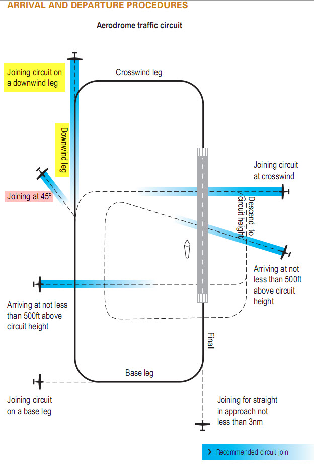
Ozbendigo, as I understand it, you have to overfly the airfield 500 feet ABOVE the highest active circuit height (eg 1000 feet above ground level if it's only you in circuit, or 1500 feet above ground level if someone else is flying 1000 foot circuits, or 2000 feet above ground level if there is a 150+K aircraft in circuit at 1500 feet above ground level). You then have to descend to your circuit height (500 feet) on the dead side if joining crosswind or descend to 500 feet when clear of other circuit traffic if joining on any other leg and you must enter the circuit AT YOUR CIRCUIT HEIGHT (ie not descend in circuit). If this conflicts with other regs (eg overflying built up areas) then your circuit entry points become limited to those that are legal. Remember that published local airport circuit rules generally take precedence over the general rules, so check out what the local rules are for your type of aircraft.
-
What's the new name for this circuit join?
JayKay replied to JayKay's topic in AUS/NZ General Discussion
I was taught to just say 'base' in left hand circuits because they are the default, but to say 'right base' in right hand circuits to help other pilots (those unfamiliar with the airfield) better find my position in circuit relative to the active runway. -
Paul, I got my waypoints from FlightAce® Country Airstrip Guide Australia Online If you subscribe then you can download all the waypoints in Excel format from their website. You then have to convert the Excel file to a format that the AVMAP will understand (I've done it but it is not straightforward). The flightace data has approximately 2800 airfields in Australia. Your AVMAP can only load 1000 so you have to cull the file, either by region or type of airfield. Garmin GPSMAP 296 and higher units can upload 3000 custom waypoints so they can accommodate the full list. I prefer the Garmins as uploading custom waypoints is much easier.
-
What's the new name for this circuit join?
JayKay replied to JayKay's topic in AUS/NZ General Discussion
Dazza, if you don't use the words 'turning' or 'joining' then how does another inbound pilot unfamiliar with your call phraseology know if you are turning downwind in the circuit or joining the circuit on the downwind leg (as we see from this thread these can be different locations in the circuit). Furthermore, a "... joining base 22 ..." call would be much more useful to an inbound pilot than just hearing '... base 22 ...' in which case the inbound pilot may erroneously presume that you are turning base for runway 22. Just my observations. -
Unfortunately, the translator is a TRAINING tool so we have to get it right for those still learning. Real pilots don't need to use it so it makes not difference to them. ;) I'll dig up the references and forward them to you.
-
What's the new name for this circuit join?
JayKay replied to JayKay's topic in AUS/NZ General Discussion
Dazza, CAR 166C requires a pilot to make a broadcast whenever it is reasonably necessary to do so to avoid a collision, or the risk of a collision, with another aircraft. A broadcast must include: (VFRG ver4 page 251) • the name of the aerodrome; • the aircraft’s type and call-sign; and • the position of the aircraft and the pilot’s intentions. The standard broadcast format for low and medium performance aircraft is as per the following example: (VFRG ver4 page 253 - example in square brackets) • (Location) Traffic : [Parkes Traffic] • (Aircraft Type) : [Cessna 172] • (Call-sign) : [Zulu Foxtrot Romeo] • (Position / Intentions) : [One-zero miles north inbound, on descent through four-thousand two hundred, estimating the circuit at three-six.] • (Location) : [Parkes] Are you telling us that you flout the rules by not broadcasting the name of the aerodrome in your transmissions? -
Ianboag, Airservices' documents address some of the issues Cficare raised re True/Magnetic directions and height above ground or AMSL when referred to in ARFORs, METARs and TAFs. Would it be possible to add these to the relevant parts of the translator to remove any ambiguity? BTW, congratulations on the top job you've done with it so far.
-
What's the new name for this circuit join?
JayKay replied to JayKay's topic in AUS/NZ General Discussion
Or maybe we could try "... joining mid downwind ..." for the 45 degree join, and "... joining downwind ..." for the extended downwind join (as per the current rules for the latter). Let's keep on guessing ... -
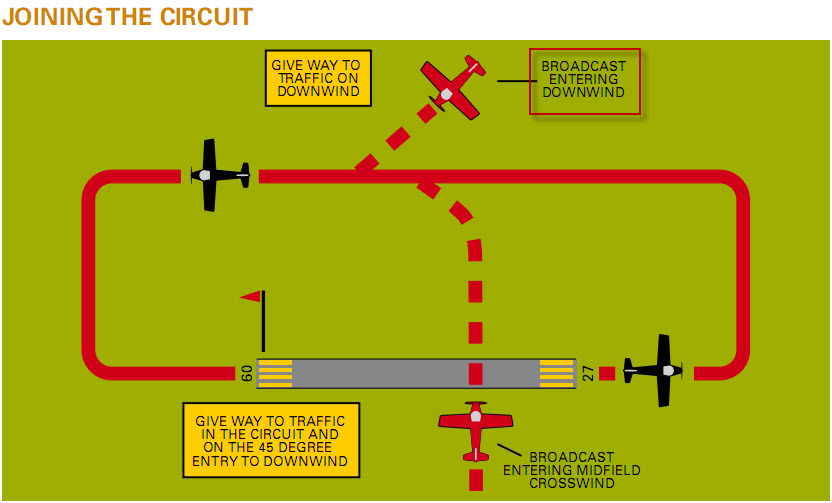
Pre 3 June 2010 an "entering downwind" circuit call meant that you were joining the circuit at 45 degrees from the active side approximately mid runway. (See diagram below from the VFRG ver 2 page 239) The new circuit rules which became effective on 3 June 2010 show the "joining downwind" circuit call is to be made when joining the circuit in line with the downwind leg - extended backwards. (See diagram below from the VFRG ver 4 page 242) What then do we now say on the radio when joining the circuit on the downwind leg at 45 degrees from the active side? "... Joining at 45 degrees for ..."?? :confused: We can't call in "... entering downwind ..." anymore because that is now a valid call for a new circuit join location. I also note then we used to 'enter' circuits, but now we 'join' circuits. I further note that what used to be known as "... entering midfield crosswind ..." is now known as "... joining crosswind ..." but the location of entry is identical. These are serious issues because when other pilots are making these calls they are giving us the big hint via radio WHERE TO LOOK for their aircraft when in circuit. If our understanding of the circuit locations is different then life in circuit will only get more stressful and dangerous. But then again, some might say that "If you didn't know about these changes until now, they are not the sort of changes that will have endangered your flying because the only procedure that you wouldn't have known about is the joining on base leg." So do we now call the old "... entering downwind ..." the "... joining at 45 degrees ..."?

-
Russ, what is the source of that info? As far as I'm aware, PMK's post is correct, there is no such thing as an 'Australian' 296. They are all exactly the same except for the base maps which have nothing to do with unit (eg. litres or gallons) settings. Your retailer may preconfigure your GPS for you to suit Australian units (some even load custom waypoints to value add), but Garmin sure don't.
-
Visual Flight Rules Guide - version 4 - May 2010
JayKay replied to JayKay's topic in AUS/NZ General Discussion
Was version 3 published as a book or was it only online? I noticed that for now, the Visual Flight Rules Guide will only be available online so that: 1. it can be updated easily and therefore remain current, and 2. it incorporates pilot feedback where appropriate. -
I'm looking at the Designated Airspace Handbook (DAH) - effective 3 June 2010 published by Airservices. In "Section 13 - Flight Information Areas" the handbook defines the outside perimeter of each area and and in the heading it lists the relevant frequency. eg. The first listed area has frequency 124.2 All good until I came across 118.2C (Section 13 FIA - 1). The area above is listed as 118.2 On page FIA-2 the following frequencies appear: 120.3A, 120.3B, 120.55A Other frequencies I've found are: 122.1A, 122.1B, 122.1C, 122.1D and these: 123.95A2, 124.6A1, 123.95B, 118.95A2 How do you dial up frequency 123.95A2 on your radio? Any help appreciated. JayKay
-
Casa have published the new Visual Flight Rules Guide - version 4 - May 2010. It can be found at: Civil Aviation Safety Authority - Visual flight guide I have a copy of verson 2 - July 2007. Does anyone know if version 3 was ever published?
-
The 495 hardware and software have been around for a long time therefore proven technology (basically a processor upgrade of the 296). The AERA series is new to aviation so I'm not sure how well debugged they are. One of the big issues with GPS units is the visibility of their screens in sunlight. I always make sure my GPS screen is very clean before I fly. The last thing I want to do is stick my dirty fingers (don't get a chance to wash my hands after preflight checks) all over the screen to use the GPS.
-
Cheap navigation - Mio Moov and OziExplorerCE
JayKay replied to slartibartfast's topic in Instruments, Radios and Electronics
I've had a look at the VNC-1 Melbourne Chart effective 3 June 2010 and found on the bottom the following copyright message which I'm sure applies to all the Airservices Australia charts (please note I am now breaking that copyright message because I am copying part of the chart without prior permission) ... "This publication is copyright. Unless specified otherwise, you may use this publication only for information purposes. Except as permitted by the Copyright Act 1968, no part of this publication may be reproduced, stored in a retrieval system, transmitted, redistributed, republished or commercially exploited in any way without the prior written permission of Airservices Australia. If you wish to use any part of this publication in any way not permitted by this notice, contact Airservices Australia Publications about a licence." Unless the Copyright Act 1968 approves format shifting it is illegal to copy any part of the chart or format shift it without the prior WRITTEN permission of Airservices Australia. It may not seem fair, but it's pretty clear. That's why we need companies like MapTrax to legally sell us the electronic georeferenced versions of the charts at a reasonable price. If we share electronic charts around for free we break the law and kill off any commercial viability of companies like MapTrax who can supply us with legal product. I'd much rather buy an electronic georeferenced version of a chart and print the parts I need for my flight (this is legal under airnav licence etc) than buy the paper chart then have to break the law by scanning it, georeferencing it, converting the format and loading it into OziExplorer. -
Hi Peter, My approach when flying with others would be: 1. Use Area Frequency or CTAF if the information being broadcast is relevant/useful to other aircraft in the area. 2. Use Chat Channel if the information being broadcast is mainly relevant/useful to the group you are flying with. Now suppose you lose sight of one of the aircraft because the aircraft is doing a precautionary search over a possible landing area. Is this information relevant to other aircraft monitoring the area frequency? Probably not, as the aircraft doing the ad-hoc low level flying is not going to impact others on the area frequency who are maintaining cruising altitudes etc. My suggestion would be to make all radio calls relating to the flying group on the chat channel (eg. have you got me sighted? etc) whilst monitoring the area frequency. But when flying at altitude where other aircraft fly then make all position calls on the area frequency.
-
And my answer is : .... 4. Left and elevator full forward
-
Hi Jordy, If it helps I've got the gear that can convert a Video Cassette to DVD.