Eric McCandless
-
Posts
125 -
Joined
-
Last visited
-
Days Won
2
Eric McCandless's Achievements
Well-known member (3/3)
-
 I am deeply shocked and saddened by this news. My condolences to his family and friends. Whilst I never met Ross, I valued his posts here as Maj Millard and as a new pilot, I quickly became aware of how experienced and passionate he was and I learned a great deal from his wisdom and expertise. It is a great and tragic loss to the aviation community. It does make one realise that since this happened to such an experienced and safety conscious pilot, it can happen to anyone. We should not become complacent and each time at least think about such eventualities and practice and refine our skills to the best of our abilities. My immediate reaction was to consider giving up the sport as my experience level is nowhere near close to that of Ross and others who lost their lives to this sport. However after giving it a lot of thought, I have resolved to continue flying albeit hopefully with a different perspective and better respect for things that could go wrong and the possible consequences. This incident in particular has caused me to think more deeply about how I can fly safer. For example I must admit I haven't thought too much about an EFATO despite my instructor drumming it into my head during training, and I have resolved to plan for it each time and be better prepared. Whilst I do practice PFLs, stalls, and steep turns on a semi regular basis, it has been quite a while since I did a glide approach. Risks are there every time we fly and we need to manage these risks. We can't eliminate all risks so we should plan to mitigate or reduce them as best we can, whether it be for engine or structural or equipment failures, situational awareness, weather, or human factors (including poor planning). Fly safe and have fun. Eric
 -
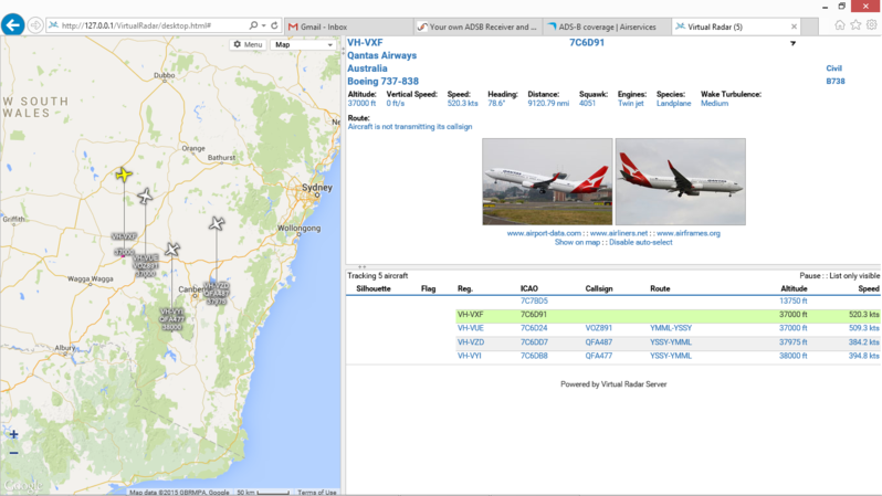
A current screenshot of the Virtual Radar application and aircraft myADS-B setup is tracking with the antenna inside my lounge room in Canberra. I would like to see what it can do with a decent exterior antenna.

-
As coljones said you can pick an up OTG USB cable from most computer shops, or from ebay ($1 with free shipping). Eric
-
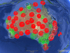
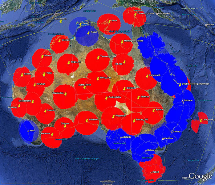
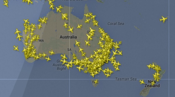
What would be fantastic for enhanced situational awareness would be if AirServices made public Internet access available to their ADS-B and mode-S servers with an API for commercial products. Presently, there are 28 ADS-B ground stations throughout Australia giving approx. 50% coverage @ 5,000 feet and 75% coverage at 10,000 feet. ADS-B Coverage @ 5,000 feet ADS-B coverage @ 10,000 feet Perhaps alternatively, OzRunways and AvPlan could negotiate with private ADS-B servers such as FlightRadar24 which is based on community participation of ADS-B trackers. Screenshot from FlightRadar24 ADS-B
-
Any interest in your own ADSB Receiver and Decoder for $10.06 brand new and displaying ADSB tracks on Android or PC? I have been researching ADSB receivers and was considering building one. Then I came across some articles on Software Defined Radio (SDR). Long story short, no need to build one, you can buy one far cheaper than the cost of the parts. I won't bore you with the technical details, but suffice to say SDR is a technological miracle, and the best part is it is very cheap. To set up a ADSB receiver, all you need is to buy a SDR on line from ebay. I got mine from a Hong Kong ebay seller called koala-ok for $10.06 including free shipping. With koala in the title, it must be ok, right? I have no affiliation with them. The device is called USB 2.0 Digital DVB-T SDR+DAB+FM HDTV TV Tuner Receiver Stick RTL2832U+R820T2 A good tip is to get the "R820T2" but a "R820T" will do ok as well, but the "R820T2" is a newer chip which has a better sensitivity. Apparently, there are some fake R820T2 USB dongles about, and some of the fakes use the older R820T chip instead (which is not too bad anyway). Mine arrived from Hong Kong in exactly one week. How can they build them, ship them to Australia for $10.06 and still make a profit? So the first thing I did was disassemble it and check that it indeed has the R820T2 chip inside. The different software decoders I tried only reports it as a R820T, but it actually does have a R820T2 chip. This software anomaly has been reported by others in the SDR community. Enough of the technical stuff. What do you get? See the image below. A USB stick, a remote control, an antennae, and a software driver disk. Don't use the software disk (does not have the ADSB drivers) or the remote (no need). The antenna that comes with it is very ordinary, and good enough to get you started, but you may want to get a better antenna and coax cable later. How to get it to work? Android 1. plug the antenna into the antenna connector on the USB stick, but be gentle, and place the antenna somewhere where it can see the sky. ADSB works on 1090 Mhz which is line of sight, so higher the better. 2. plug the USB stick into the On-The-Go (OTG) USB adapter that came with your tablet/phone and plug into the USB port. 3. Go to Google Play Store and download and install "Avare". 4. Start Avare and click on "Map" and you should be good to go. If an aircraft with an ADSB transmitter is in range (roughly 50nm) you should see it. 5. enjoy. PC (there are probably other easier ways but this is what I did) 1. plug the antenna into the antenna connector on the USB stick, but be gentle, and place the antenna somewhere where it can see the sky. ADSB works on 1090 Mhz which is line of sight, so higher the better. 2. plug the USB stick into the USB port. 3. download a driver called "SDRSharp" from this site http://sdrsharp.com/#sdrsharp 4. unzip into a folder and run the "zadig" application to install the USB drivers by clicking on "Install WCID Driver" 5. from the SDRSharp folder, run the "ADSBSharp" decoder application and click on "Start". If there are ADSB aircraft in range, you should start to see a figure in the frames per second box. 6. Now that the radio is receiving and the ADSB decoder is decoding, you need to run a map display program. I selected (randomly) a program called VirtualRadar, but there are many others. VirtualRadar can be found at http://www.virtualradarserver.co.uk/Download.aspx. Run the setup program and run the VirtualRadar program. A screen will come up and start to display a message count. Click on the hypertext link on the initial screen http://127.0.0.1/VirtualRadar/desktop.html and a map will open and after a while will display any aircraft being received and tracked. The map initially is centred around UK Heathrow, and you may have to pan the map to your location in Australia. 7. If you have trouble, have a read of the SDRSharp and VirtualRadar websites as I am not a guru on the application software and it took me a little bit of fiddling to get it all to work. There are probably easier ways to get ADSB to work on the PC, but this was my first attempt to get it working in one night. Android was far easier and just worked. 8. enjoy. Apple 1. no idea as I don't have one. Have fun. Eric
-
Fortunately that was not the experience at the school I trained with. There is no way my school would allow this. I really hope it is not the case with other schools either, as I share the skies with their graduates. Eric.
-
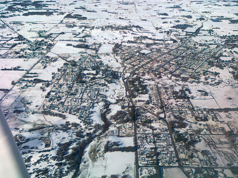
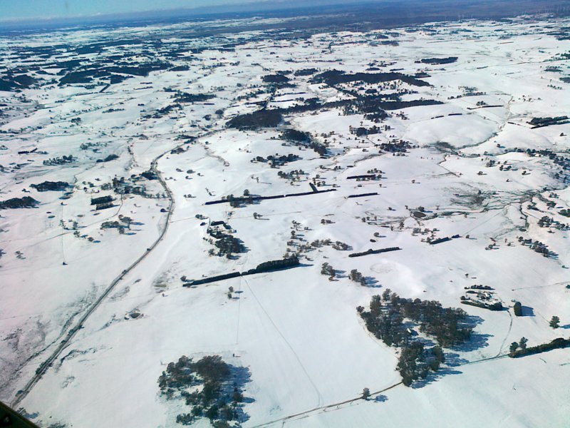
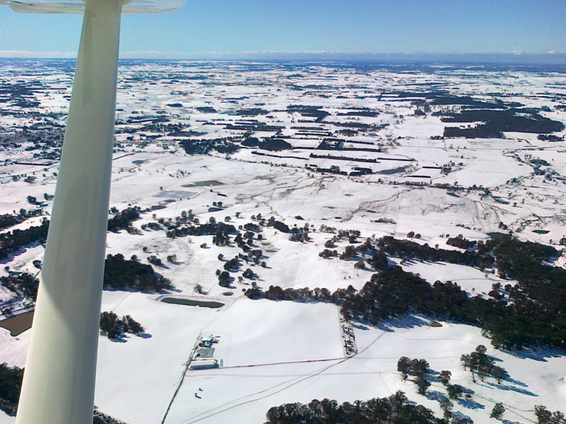
It snowed around the Goulburn district last Thursday night, one of the biggest snowfalls for about 20 years. Here are some photos taken on Saturday (approx 36 hours later) over the town of Crookwell and surrounds just to the north-west of Goulburn. Eric
- 8 replies
-
- 13
-

-

-
Hi Kaywoman68, It sounds like you really enjoyed your experience as a passenger which is great. Apparently not everyone enjoys flying in light aircraft. Most of my friends are too busy washing their hair or cleaning the bathroom to come flying with me, but perhaps that is more reflective of their confidence in me as a pilot than the prospect of flying itself. Flying is not meant to be exhausting as you say and it should be fun, so perhaps your pilot friend didn't allow you to just enjoy the experience instead. I note that you have what looks like a Spitfire in the background of your avatar, so perhaps you might already have the flying bug as a lot of us have but you just don't realise it yet. Maybe you should try a TIF as your friend suggests, and see how you go. There is a RA flight school at Goulburn which is not too far away from Canberra. But beware, once the bug bites, it bites hard, and there is no cure. regards Eric.
-
Yep that what they told me as well two months ago.
-
Just tested the beta 1.1 and the same issue. Cannot install to ROM or SD card. Only loads to main memory and then fills with map data and crashes. Oh well, one day perhaps. Eric
-
I have exactly the same issue with my Chinese based tablet (Octacore, Retina, 2GHz, 2 GB RAM / 32 Gb ROM) and it is not presently possible to install it onto internal ROM or SD card for my device. On my device, it will only install to RAM and eventually fills the RAM with chart data and then crashes. The option in Android to install onto ROM or SD card is greyed out. Many others have the same issue, but some devices install correctly. It seems to work correctly on some devices but not others. I am one of the beta testers for Avplan lite and when I reported it a few months ago, Avplan told me they are aware of the issue and would release a fix in the future. A new beta was released today, but I have not tried it out yet. Hopefully it is fixed in the latest beta. If I get a chance, I will try it and report back. Eric
-
Goolwa fatal yesterday ?.....any details.
Eric McCandless replied to a topic in AUS/NZ General Discussion
My apologies. Post deleted. -
What age is a good time to stop flying
Eric McCandless replied to dan3111's topic in AUS/NZ General Discussion
Yesterday (Sat) at Goulburn, I met a guy named Bert who flew in from Merimbula and was intending to fly a final leg to Cowra today (Sun) to complete a round Australia trip in his RA-Aus plane. He was 90. Eric P.S. I just Googled and found the following links http://www.busseltonaeroclub.com.au/news.html https://www.facebook.com/Cowraaeroclub What an awesome achievement even for someone much younger, but for a 90 year old it is spectacular..... -
Flying Trip from Goulburn to Lightning Ridge - 26 to 29 Sep 14 My friend Mark who also happens to be my L2, invited me to join him to fly both our aircraft to Lightning Ridge from Goulburn. He and friend Alan would travel in Mark’s Jabiru LSA55 and me in my Jabiru J170. I am still a reasonably low hours pilot, so the opportunity to travel with a more experienced pilot was great. Read more at .... https://drive.google.com/file/d/0B-4Rw0WdHM2JNXUtM2xGX3E2NDA/edit?usp=sharing
-
When on area frequency, I often hear ATC report position and altitude of an unknown aircraft to a known aircraft. The source of the unknown aircraft's altitude will be the transponder pressure altitude which is referenced to 1013 hPa (not compensated for QNH). If the QNH is high at say 1031 hPa, then the height difference between the transponder's pressure altitude and an aircraft altimeter altitude set to QNH would be (1031 - 1013) x 30 = 540 feet. So what altitude is the ATC reporting? Is it the transponder pressure altitude or a QNH corrected altitude to reflect what an aircraft altimeter would be reading? I am hoping it would be the latter. Eric