Bigglesworth
-
Posts
379 -
Joined
-
Last visited
Content Type
Profiles
Forums
Gallery
Downloads
Blogs
Events
Store
Aircraft
Resources
Tutorials
Articles
Classifieds
Movies
Books
Community Map
Quizzes
Videos Directory
Everything posted by Bigglesworth
-
Meanwhile Worth-Big-$ is thinking "I have been called an inspiration before, but I didn't realise it was just for a mad story. Then to justify his new name, he immediately puts a lawyer on a retainer to sue for inspiration value as soon as the movie of the NES comes out. However the lawer you replies "you got more urgent things to think of now m'boy. And that will be all your life saving for telling you that" So Les-worth-big throws him the $2 he left after spending the rest on new guitar strings, and a bottle of avgas-cum-bundy. Then he looks at all the planes circling the area and the wreckage that has occurred over the day..... and wonders "am I the only one with a job here?" Exits left listening to Barnsey's "Working class man" Lands on roof of big Melbourne department store to buy more RM stickers for his plane, and takes advantage of the fact that there are no checkouts on the way up to the roof. Gets shot at by security, but as he walks away says "never pick on a bloke who's plane rego is .222" Not such luck for Slarti, having chosen bad rego numbers, his luck soon ran out and due to total engine failure, the Cheetah slowed down so drastically so it could only just keep up with the 747, but could still outclimb it. Tin can indeed.
-
Tee hee, I'll be at avalon if I can find it. though I have been told I couldn't find Russia if I started in downtown Moscow. I might be flying all over the country first, and the lecture will be called: Avalon via Brisbane, or what I thought was Brisbane but only took me 2.5 hours to get there. (might still be Brisbane [one eyed Cheetah fan]) But thats OK, as BigPete points out: fuel is not an issue when you run on a combination of bio-fuel, the smell of an oily rag, and a shot of Bundy to wash it down. Meanwhile, since I was told off for listening to music, and have had too much time for texting people while flying: I've been working on a way of guitar practise while flying.... Combining a cheap ukelele with a pickup out of the guitar that got run over by a drunken Canberra teenager, and a few circuits from Jaycar, I can wire it to the intercom music input. This means that I'll increase my concentration levels (important when flying), exercise my fingers to keep of deep vein thrombosis, and will be able to busk at the destination airport in return for a bit of real fuel because I ran out of oily rags, and drank the Bundy to keep the music flowing...... See you at Avalon, just but you have to throw coins in the Ukelele case. I'll be there the whole time, 'cos I'll need the cash to get home. I'll try to find a bigger mountain to cross this time. Then I can write a trip report about it.
-
Hey, Yenn Now people are starting to see things my way ;)
-
Apologies to people of Toc, I'll modify that.
-
Unless they've changed it since I learned the rules, Under 1000ft AGL or 3000ft AMSL the requirement is 500 feet AGL (1000 or gliding distance over a town) and clear of cloud. So I was legal..... Also, there would have been no probs going over the clouds, they were full of holes. But thanks for the route, turboplanner, I might try it...... Well at least some people enjoyed reading it.... Next trip gets called fiction....... proof that truth is stranger than fiction? ;) PS listening to music while flying: I'm a mechnic, I'd pick something wrong long before most, music or no. I have proven this on a few occasions. Not so much on planes, but even then......... PS I had checked all the online forecasts I could get the night before. I will have to check the validity times of Arfors, but I am under the impression that you can't get them the night before? Anyone know? As for nav with nothing except a map, I'd do it anyday. Not bragging. I've done it. When I did the nav test I was in totally unfamiliar area, and after a few diversions on instruments, the instructor said "right, now you don't know exactly where we are, since we went off the plan, find this town" Which I did no problems. And it wasn't on the coast or anything easy like that. Hey I'm not flaming anyone..... If Ian wants to move it to the laughter section, it would fit nicely. Especially now:laugh:
-
@turboplanner So you believe me now? :) Hey anyone noticed that while everyone has been saying I've been reckless and whatnot, no-one has yet put there finger one on real wrong doing? Or at least not one major unsafe issue. Sometimes my writing 'talent' goes the wrong way...... Re-read taking out all the superfluous words/phrases. It was a nice flight, nothing went wrong, except a change of route. I picked up all waypoints, and got home with plenty of fuel and plenty of daylight. And a warning to other pilots that the area between Shepparton and Mt Baw Baw is not designated remote, but that won't help you if you go down there. Sound better?
-
I just checked again........ draw a straight line from Tumut to Toc.... The Rock is about 12nm to one side, Oaklands ~7 Berrigan is also ~7, Riverina Hwy, of course. Just where was I on the highway, or was that that road I passed earlier, and were those 5 houses a town? Don't laugh, you find Tanja (near Merimbula) its marked on the map, but you really need to know it to identify it, and even then you aren't sure. I don't trust small towns after flying over that. Look forward to meeting you..... PS, I never believe in insurance. I actually carry 24 hour accident cover, I need it for work, but apparently they don't pay out in cases like light plane crashes. Darn, looks like I might not be banned, I was already looking forward to telling my mates that I got kicked off an ultralight forum for being unsafe.........
-
PS @captain Caroline happens to be one of the few people who call me "sensible and responsible" Few people call me this, but they're the ones who know me the most. It always annoys me, because deep down I know its only too true. Hey, how about I meet you some airport on the weekend, thats if I don't have to work (depends on the timber supplier), or the weather turns bad (depends on God)..... might be interesting to have a chat.
-
I spelled it 'ded' short for deduced on purpose......... :P Actually I was using pretty much pure map reference navigation. I don't know its real name but I call it leap-frogging. Thats why I like lots of features, so I always have a permanent reference. they were all short legs, with a backup plan e.g. steer a bit south to hit the river on the east side of town. Or a bit east to the coast, follow that to something identifiable. I did pass my PPL theory with 88% at 15...... I'm not entirely stupid.
-
Oh alright Ian, ban me and and delete the post, its the only way...... first a let me say a couple of things. Please. How come as soon as I open start typing people start getting annoyed..... I emailed the same all my friends and they didn't seem to think it was anything special. For me. Anyway, one by one..... Mt Baw Baw...... Definate nav reference on that, didn't need the gps to tell me that one, I stayed to the west, and was beside it. The clouds touched it at the top. As soon as I passed it it opened up, but those photos were taken just before it. @Captain I take it you have flown that route? Enough waypoints to Henty. After that one road looks like the next, and there are plenty not on the map. The Hydro Scheme is a good waypoint, if you know what it looks like........ there's also the town of Saversnake, again, its good if you recognise it. Easy enough to Ded-reckon navigate, and I would have been able to. But I was being lazy,and would have used intentional error navigation. Lighten up guys..... I knew there would be a bit of trouble, but not that much. Come off it, in safety terms: My nav skills were equal to a failed GPS. In fact I hardly used it as it was, except on the one leg. The path was over good ground, until around Mt Baw Baw, and if anyone knows how I could have know this was horrible area, let me know. Please. I thought I stayed out of remote area. I had a good reserve of fuel the whole time and a good reserve of time. What have I missed. Oh well and you might as well delete this. PS, as for listen to the radio and fly...... Does everyone out there really get a TAF/ ARFOR before every flight?
-
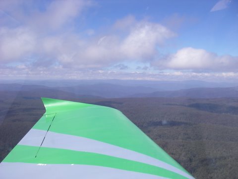
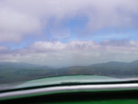
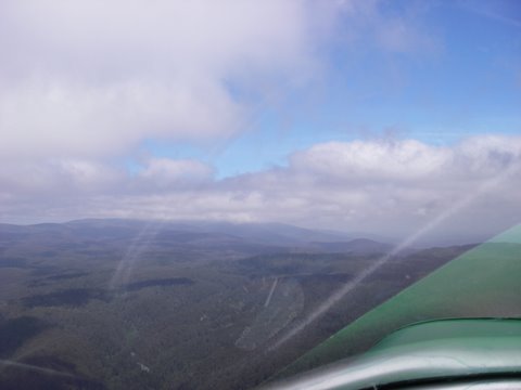
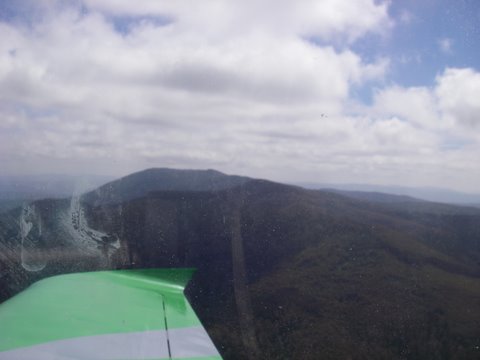
Righty-o I'll start this trip report off with a bit of background.... I learnt GA nav when I was 15 (and passed the theory quite nicely) So I know all that ded-reckoning stuff using both sides of the wizz wheel. And using TAFs and ARFORs..... I learnt Rec. nav, when I was about 18, and pased that fine. I like that style: listen to the forecast on the radio, then point in the rough direction you want to go, find a mountain that in your track and go up to it and around it. Simple. Anyway, so far, with 30.9 hours in my lovely Cheetah, I still haven't been on a nav anywhere where I don't know the area. But this changed when a girl I know moved across the mountains to Tocumwal....... so I had a reason to fly somewhere. So to cross the mountains wasn't really a good idea, especially since that epirb I bought hadn't turned up yet. Neither had my aircraft grade compass. So I had a bottom end e-trex GPS, and a $2 compass. (I also had a handheld backup compass) Thats was good enough for me. But I still wanted to go around the mountains, and around Canberra. I first tried on Saturday, but I got stopped at Moruya by some of the worst weather I have flown in. And the fact that Caroline would be busy on Saturday anyway. So there was a break in work, and a break in weather, on Monday. Get to Frogs Hollow in the morning, do a good pre-flight, top up with 98 premium and tie a 20 litre spare in the back compartment. Alls good, wind is strong, but in my direction, and the forecast says dropping. Take off and head towards Moruya, plenty tailwinds, a bit of cloud, medium turbulence. The GPS shows a maximun GS of 149kts, and when at (just under) 5000 feet it could climb at 1400fpm, with full fuel, spare tank and one small pilot. Anyway it was no fun on top of the clouds, so I went back down. Got to Moruya, turned inland, could see the hill near Braidwood, went straight to that across the mountains. And the wind dropped off, which was good of it. I had been as far as Braidwood before, but from then on I was in new territory. But I had my flight plan drawn up. Well, actually I had the maps in front of me with a couple of lines on them, and a rough idea of their lengths. For VFR I don't need more than that. So next point was Lake George, staying low under controlled airspace. Then on to the only big town I could see which was Murrambateman, By now I had noticed that the GPS was doing roughly what it should be, so I thought I could trust it for short periods of time. I would rather trust my $2 compass, and it was doing a good job, but I paid about $150 for the GPS and wanted to get my money's worth out of it. So I let the GPS take me to Tumut. Last airport before Tocumwal, was thinking of stopping for fuel, but the gauge was showing enough, and since its a sight line, it had a hard time lying to me. Now the fun really starts....... I sent Caroline a text saying "at 5000 feet over Tumut, eta Tocumwal in 1.5 hours" I never did log the time, or work out the eta as a time. I always kept track of intervals, well sort of; I had the cd player going the whole time, and worked them out in the number of songs, using an average of 3.5 minutes per song. Luckily I didn't listen to Alice's Restaurant........ 18 minutes I think...... Anyway, Caroline texts me back saying "um, I'm in Shepparton today" Great......... Grab Ersa.... Shepparton, yes, has airport, not controlled, not security controlled. Fine, can't change flight plan because it might touch Albury (I think) controlled airspace........ Text back "call you from Toc when I stop for fuel" So for Tumut to Tocumwal there is approximately no markers for a reference....... I can picture the GA pilots looking down every 10 minutes and saying " absolutely nothing on the map, and absolutely nothing down there; we're on course" If the GPS went out there, I would have had to turn south until I find the Murray, then follow it westward to Tocumwal........ *DELETED* Anyway, the airport was deserted except for a glider doing something unproductive and needing a powered plane, then coming back to say how much better it is without motors. Silly as a pushbike........(the greenies haven't got to me yet) Anyway, no way to get fuel without a Mobil card, the contact numbers in the Ersa were not answered, so I checked I had enough for Shepparton, finding 20 or so litres, I rang Shepparton...... got a message saying number is disconnected...... retried using 03 before the Ersa number..... got answer that fuel is easy to get. Fine, told Caroline I'll be in Shepparton in about 15 minutes, and left this *DELETED* town, and headed south..... Who made these bloody roads? Corners are the fun parts of driving.... not 50kms of dead straight thumb_down Anyway, get into Shepparton airport, I've been in the air 4.1 hours and I put 54 litres of fuel in the tank..... thats 13 litres an hour...... the GA bloke who sold me the fuel looked jealous......... Jealousy is a sin folks. Anyway Caroline still hadn't found the airport, her sister who was with her had lived in the area all her life, but no idea where it was. And all I could say was "I could see 2 roads to the south, its on the westmost one" And she was like "where's south?" Anyway got to see her for a while eventually. Actually not very long, but the plane has the same attraction, so I didn't really worry :) So from there back home. I looked at the map and realise I could go under the remote area, and it would be quicker...... Set up the GPS, drew some lines on the map, asked a passing pilot of his opinion since he would know the area better than me, but it turned out he was a chinese student pilot from the west. He was friendly, and liked my plane, so he was a good bloke, but had no idea about the route I planned. Not that I could really understand him, even less his radio calls. Anyway so DCT Shepparton to Mt Baw Baw....... Anyone done this? One word: don't I've attached a few photos of what Mt Baw Baw is like...... just imagine about 60nm of it...... Its that sort of creepy feeling that if anything goes wrong...... there's no-where to land, and nothing down there. then you start thinking about how this was a last minute idea, and being VFR outside remote area, no flight note was lodged.........so I would be looked for many 100s of nautical miles away....... So I said a prayer for a safe flight, and put Dire Straits on to take my mind off the danger. The former was 100% effective, and the latter a bit less so. [ATTACH]6951.vB[/ATTACH][ATTACH]6952.vB[/ATTACH][ATTACH]6953.vB[/ATTACH][ATTACH]6954.vB[/ATTACH][ATTACH]6955.vB[/ATTACH] But I was happy to get around Mt Baw Baw, even if I had to seak between about 700 feet cloud ceiling...... then the ground dropped away under me, and a short time later........ GRASSLAND.....:thumb_up: I stayed at the foot of the ranges from then on, although I went back into danger area near Delegate, and was wondering what it would be like to try a forced landing on the Snowy river....... Thank God I didn't have to, and thank the Straits that I kept a calm mind and had all my emergency procedures running through my mind.... just in case. After Delegate it was plain sailing back to Frogs Hollow. For a grand total of 7.2 hours. I will have to put a cruise prop on, this climb prop is too slow. Anyway..... it was a lovely day, and I got back home (3/4 hr drive from the airstrip :( ) and found the epirb and the compass, waiting for me. Talk about timing. Anyway now I know I can get around it......... But don't try Shepparton dct to Mt Baw Baw unless you have faith in either your plane or a powerful deity. I have faith in both, so I was right. I still don't want to do it again in a hurry. Looking at the map, Frogs hollow to Tumut via Eucambene looks a lot less remote, just a bit higher. I'll try that next time. Might also try letting the welcoming party know I'm coming in advance. So, for a first solo nav, I think ~660Nm wasn't too bad. Especially when it cost $103 to refuel in Shepparton, and will probably be $50 of BP98 over here. I'll have to arrange premium fuel over there. Oh wait, straight line, just over 2 hours, it can do it in one tank, especially if I fill the 20 litre reserve in in Tocumwal. Long live recreational flying...... and a plane called 'Cowboy Up' You gotta Cowboy Up When you get throwed down Get right back in the saddle as soon as you hit the ground you've heard that the tough get going when the going gets tough round here what we say is Boy, you better COWBOY UP BTW, Caroline is only a friend, and it was the flight that mattered. I still call it a good day :p

-

Relative safety of recreational flying
Bigglesworth replied to Bigglesworth's topic in AUS/NZ General Discussion
No the object isn't to find out the real figures, just how often google finds a report of the scenario. I typed "died in an ultralight accident" into google and got 36,900 answers. For a comparison, type in 'died in a mule cart accident' or something like that. I was thinking of putting it in the funnies section, but its half serious. Well, not really. In fact it should be in the funnies section. Died in a forum incident=4,420,000 Sh*t better go -
Found this on the net.... 'ultralight' has 36,900 I wasn't game to try car.................
-
Hey, its interesting that I put my MySpace link there, but still no-one knows me :) Someone mentioned Murphy's Law. One of my favourites. But I use it in its original: as a safety principle..... Murphy's law originally went more like: plan to expect that the whatever can go wrong will go wrong, and make sure it is still safe. Basically all electronic devices can fail, motors stop at the wrong time, your survival kit gets damaged/lost, you can take the safest route and it can still kill you. And all the gear in the world can't save you in a lot of conditions. In fact the epirb etc. only caters for the small window of accidents where a: the devices work and you are in a position to be rescued b: you can't get out of there anyway So they are pretty limited
-
I couldn't resist...... I just got the True newsletter Weird News -- Randy Cassingham's This is True check it out; its good...... anyway this was in it: THE LONG, UPHILL BATTLE: The "mindless" attempts by government and society to eliminate all dangers in life are threatening personal freedom, says Tom Mullarkey, chief of the U.K.'s Royal Society for the Prevention of Accidents. "The application of common sense and balance is much more reasonable than the seeking of mindless increments towards 'absolute safety'," he said, which is "a destination which is neither feasible nor, in all probability, desirable, since it would come at such cost to our freedoms." While some areas obviously need regulation, he says, such as nuclear power and aviation, individuals should merely be given information on safety and be allowed to make their own decisions on whether risks are worth taking, so long as they don't put others in danger. BTW, I went for a fly today, talk about bad weather...... tried to cross from Moruya to Braidwood......was about 10nm off the moutains, at 5000 feet, full power,climb configuation (normally would be about 900-1000fpm) 65-70kts on the clock. Not climbing, battered by tubulence, and the gps showing 35kts groundspeed :-s I gave up at that.......
-
Remote is relative. Very much so. I live only 10kms from the coast, yet you could get lost and in dire trouble about 1km from my house. Not once you know the area, and are used to paying attention to land grades and directions...... eventually you'll find something. But we can find danger in everything, the question is: where do we draw the line? And in my case I don't worry too much about the obvious danger; its my experience that its always the little things which do you in. I don't tell anyone to try to follow my example, but I can get 5 kms across a mountain range and end up where I want to be. And I'd much rather be stuck in a mountain range than in a desert. There is water there anyway..... But prevention is the best cure.......
-
I crash and die and get my money's worth out of the epirb........... Simple answer. Other answer includes Lake Eucumbene..... it would cool anything down........... Or 30 degrees minus 2x6.5 (6500 feet, mountain are sufficient reason to go above 5000) is 17 degrees....... Its a cold day in the alps......
-
Sorry, that should have been "I do intend to crash and want the worst outcome" I don't know how you could have misread that typo........ I suppose I'm buying an Epirb to throw out of the window so I can lighten up the load if I need better climb. Not to mention a new 2nd hand better compass, and gps for backup. They're good for throwing out as well..... Seriously folks, I'm not mad. But if your time's up nothing can save you. And my track would follow close enough to the road. I can get there quickly (after leaving a note at remains of plane) and get a lift to where I get mobile coverage. Actually around there has service because they need it for the skiers. And if I can activate an epirb, I can dial 000. @K-man thanks..... as yet she's just a good excuse to get some flying done :)
-
Thanks, just the info I needed. It'll work, but only just which suits me fine. As for price, Garmin say RRP is $149AU Wade air sells it for about $195, ebay is at a buy it now of $143, or try to find a lucky deal....... I'll see if there's anything better out there, but I think I'll be up for $143 if I want it in a hurry. Thanks, Joshua
-
Since we are only allowed to use GPS as a backup....... I noticed Wade air are selling the etrex range of GPS. Are they any use at all? they're on ebay for about $130, to give you an arrow to follow, and to give you co-ordinates, that about all I need. The next one is the 96 and its a lot more expensive, and doesn't have a 12v adapter facilty. It would still be a better unit, but is it worth that much when I will be retiring it in the not too distant future for a 296 or similar. GARMIN ETREX H HANDHELD OUTDOOR GPS " BRAND NEW " - eBay, GPS, Electronics. (end time 07-Dec-08 08:44:32 AEDST) thanks in advance for your help, Joshua
-
I'll bite back But first I'll say you're right. Secondly I'll say quote the hitchhikers Guide to the Galaxy and say the answer is on a packet of toothpicks: When the human race is so stupid it need instructions on how to use a toothpick, no wonder they need to make laws to stop us killing ourselves. Not realising they are stopping evolution, but thats another story. I do realise in hindsight that Ian is probably going to suspend me and delete this thread. Still, I have my advise, and my Epirb, and I don't really intend on crashing. But I'm still confident I could get out alive if I did crash..... I was only biting back at being told a GPS is a must. That is opinion, and while I appreciate opinion, the same people who get bad ideas from my ideas, get wrong ideas form opinion. And of the 2 I prefer to be intentionally unsafe, than thinking you are safe when you aren't.
-
Have spoken to him and it is "Australian stock for Australian conditions" Didn't say it earlier, didn't want others taking my bargain. Bought now :) Thanks for all your help, western NSW here I come. To be exact, to the girl who just left the area for Tocumwal (across the range)
-
Thanks for the info. GPS funcationality is a must I did mention I only wanted to be legal and wasn't too worried there even. What do you reckon about this: GME MT410 Personal 406Mhz Epirb - Brand NEW - eBay Safety Equipment, Parts, Accessories, Boats, Watercraft, Cars, Bikes, Boats. (end time 06-Dec-08 17:20:54 AEDST) It is from an Aus seller......
-
I was thinking of a few navs which cut across a bit of remote area. I read the regs and it seems all I need is an emergency locator. Is this right? And is a handheld PLB enough? And whats the cheapest available? (I'm not too fussed about being found, I'm a survivor :)
-
Why the skeleton could't cross the road? He had no guts