

Garfly
-
Posts
3,051 -
Joined
-
Last visited
-
Days Won
67
Content Type
Profiles
Forums
Gallery
Downloads
Blogs
Events
Store
Aircraft
Resources
Tutorials
Articles
Classifieds
Movies
Books
Community Map
Quizzes
Videos Directory
Posts posted by Garfly
-
-
Yes, we're all going for our bushcraft badge.
-
 1
1
-
 4
4
-
-
There's a vid for that ... 😉
-
-
The final two films in the series:
-
1
-
-
Maybe a solid fuel stove like this?
This guy reckons you can also use alcohol fuel with it at a pinch.
-
 1
1
-
 1
1
-
-
It turns out the Vilnius 737 crash, too, came down to simple wrong switch flicking:
-
1
-
1
-
 1
1
-
-
-
A new and nicely done video review of the Nynja from France.
English subtitles are available by way of YT's CC button.
-
2
-
1
-
-
A Dynon, or similar PFD, is only able to report TAS because it's fed air data (pitot/static) along with outside air temp and is privy to pressure altitude, so it has all it needs to calculate TAS. (Like you can do manually - and roughly - on some old style Air Speed Indicators by dialling in OAT against PA).
But an EFB - if we're talking portable tablet devices - has no clue as to TAS because it gets no air data.
-
 1
1
-
2
-
-
Sweet AND sour? ;- )
-
1
-
-
3 hours ago, T510 said:
Anyone using something like this and have any feedback they would like to share?
My wild guess would be that maybe half of all VFR aircraft flying around these days are using some kind of ADSB-out device.
Just judging on the number of aircraft one now gets to hear AND see. (And all IFR flights must have it.)
Even more would be making use of some kind of IN-only solution.
The government subsidy plus low cost gear plus increasing acceptance all seem to be working.
So when you're ready to formulate questions I'm sure you'll get plenty of answers here..
-
1
-
-
T510, Congrats on the Cub! As you've probably worked out, self-contained solutions involve an approved portable ADSB IN/OUT device (like a Uavionix SkyEcho2) used with a tablet (iOS or Android) used with an Electronic Flight Bag (EFB) app such as OzRunways and AvPlan. You could poke around on this site, searching for "SkyEcho2" or "SE2" and you'll be deluged with passionate chat about all of the above, but maybe as an intro to the subject you could look at these sites (you can also look for YouTube tutorials):
 ADS-B Devices | OzRunways
WWW.OZRUNWAYS.COM
ADS-B Devices | OzRunways
WWW.OZRUNWAYS.COMand here:
Traffic Displays - AvPlan EFB - Electronic Flight Bag
WWW.AVPLAN-EFB.COM
Recent events have sparked a debate about the usefulness and capabilities of EFBs and traffic displays. At AvPlan EFB we […]
SkyEcho - uAvionix
UAVIONIX.COM
Australia ADS-B rebate program round 2 is open! Save now on SkyEcho! Learn More SkyEcho Electronic Conspicuity SkyEcho is a portable ADS-B IN/OUT transceiver consistent with the UK, Australian and New-
2
-
-
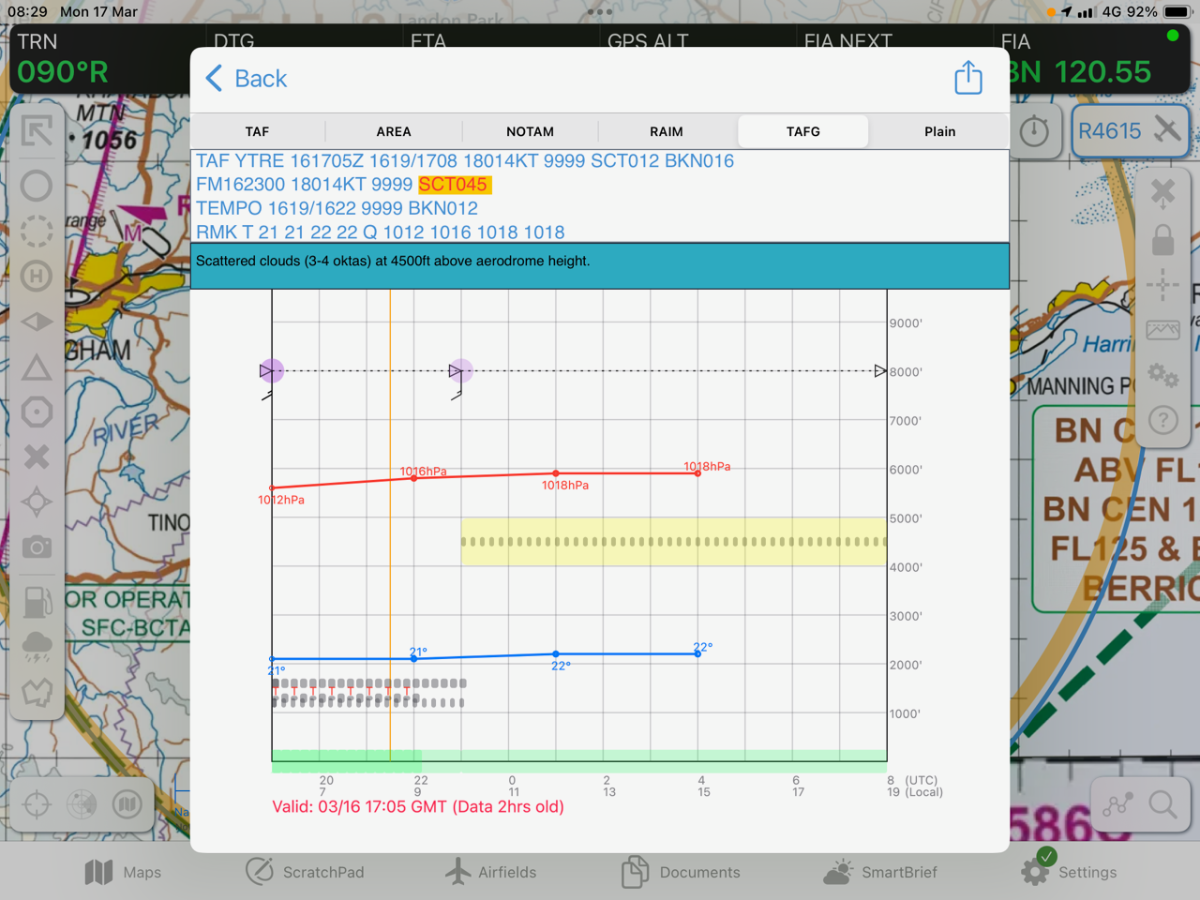
13 hours ago, Area-51 said:
Ozrunways has TAFG which is a useful tool however it does not combine departure arrival destinations together. That being said there are other Wx tool charts in Ozrunways that will present transiting conditions for the flight plan entered.
Yes, here's a sample TAFG which does unfold an AD's forecast across a timeline.
It'd be interesting to see the idea extended to a planned route.
CLICK FOR FULL REZ.
-
6 hours ago, facthunter said:
So much NOT mentioned there. At least it advises Caution.. Nev
4 hours ago, Freizeitpilot said:Yes - grass is such a different animal to bitumen, amongst other things.
Of course it is, but how does one come away from that video imagining its authors simply missed that most basic fact (among others) ?
Clearly, the film's starting point is that as pilots we KNOW that Density Altitude can kill; likewise a heavy load, a tail-wind, an up-slope and, to be sure, a draggy, clingy surface. (Before we even get to our own skill level and our own aeroplane's declining vigour.)
The point of the Air Safety Institute video (far beyond just preaching "caution") is that, added to all that, your POH can also kill, if you put unwarranted faith in its P-chart claims.
The experiments that the video team took pains to do turned up the shocking results that book take-off figures were, in the real world, fully 30% "optimistic" (in 2 common GA types).
Yes, of course, they did these experiments on bitumen but the whole point of P-charts/Tables or Take-Off Calculator apps is that a good set of numbers from any given situation can (by extrapolation/interpolation and known factors) yield rough results for most others. With, of course, an added margin for safety.
But that unaccounted-for 30% error stretches 'rough' to its very limits - and in quite the wrong direction.
Which is probably why AOPA/ASI recommends adding 50% to book figures and urges us to "Go fly and test this for yourself!"
-
The(US) Air Safety Institute rolls its own:
-
1
-
-
2 hours ago, djpacro said:
CASA has this sensible new AC:
Yes, thanks DJP. Here it is as .pdf:
-
1
-
-
36 minutes ago, facthunter said:
You can't just make up your own rules and figures.
No ... but it can't hurt to do your own reality check on your aircraft's book figures - assuming you even have P-charts for your plane.
"I’ve personally had the miserable experience of beginning a takeoff roll in a type-certificated light plane and not being sure that I’d have enough of a climb rate to stay safe in the initial climb. I was pretty sure, but I was flying a very old airplane with a very thin POH, and I didn’t have any way to be certain. This is an experience that I never want to repeat ... " Jared Yates, Kitplanes.
Predicting Performance
WWW.KITPLANES.COM
John T. Lowry's Bootstrap approach makes it easy to create performance charts for your pilot's operating handbook. By Jared Yates. -
In the video, Jason Miller urges against trusting your life to book figures at all - even your own POH's ones.
He says add at least 20% to the book figure (after all other factors in "Notes" have been accounted for).
Plus, as a back up, he pushes the 70% of rotation speed by 50% of runway length rule.
It's too bad DJP never got around to building that app.
On 11/12/2017 at 2:31 PM, djpacro said:Back when the DoT (before CASA) used to produce ‘P’ charts to go in the Australian-specific flight manuals they used some straightforward software to correct measured distances to ISA SL and MTOW. It then printed out those ‘P’ Charts. A camera was used and distances/heights measured off the printed photo to get distance to/from 50 ft to the ground. People standing beside the runway marked ground distances,
Some years ago I ran a Uni Course which did that as a student project using some more modern tools. I might still have those notes on how to do it (consistent with FAA AC 23-8 FAR 23 Flight Test Guide).
Perhaps I should develop an app and retire on the profits from sales?
CASA has similar info with details at https://www.casa.gov.au/file/122726/download?token=NFLC3fMe with a further reference to FAA AC 23-15.
Unfortunately, that CASA link doesn't seem to be working any more.
-
-
-
-
37 minutes ago, Methusala said:
Do you believe that only unqualified people make bad decisions?
Good point. And some weather decisions are a lot more straightforward than others.
Anyway, lest we're tempted to think it's mostly risk-taker types who get into strife; a cautionary tale from ATSB:
VFR into IMC involving a Piper PA-28, VH-FPS,
near Warrnambool, Victoria, on 25 February 2021
Safety summary
On 25 February 2021, a Piper Aircraft PA-28, registered VH-FPS, operated by Moorabbin Aviation Services, departed Warrnambool Airport for Moorabbin Airport, Victoria. The flight crew were conducting a training flight under the visual flight rules (VFR). There was an instructor, student pilot and a passenger on board. During the cruise, the weather deteriorated and the aircraft was returned to Warrnambool. As the aircraft approached Warrnambool, the visibility reduced and the instructor initiated a climb into cloud. They contacted air traffic control and received navigation assistance to an area free from cloud. The flight then proceeded to Moorabbin Airport where the aircraft landed safely.
The CASAbriefing video below actually analyses that incident but then goes on to offer useful tips on proper interpretation of NAIPS GAFs, TAFs etc. The meteorologist urges pilots to talk to the relevant BOM aviation person whenever in doubt about a forecast (the phone number for the person handling your flight region is always at bottom left on the GAF).
-
1
-
-
You could PM Kyle Communications on this site for more info.
-
1
-
-
1 minute ago, turboplanner said:
I would suggest you take some notice of comments on a current legal issues for RAA.
And you should brush up on your libel law.


New electric developments
in AUS/NZ General Discussion
Posted