
Garfly
-
Posts
2,751 -
Joined
-
Last visited
-
Days Won
58
Content Type
Profiles
Forums
Gallery
Downloads
Blogs
Events
Store
Aircraft
Resources
Tutorials
Articles
Classifieds
Movies
Books
Community Map
Quizzes
Posts posted by Garfly
-
-
This is a tech explanation of the various 737 mid-cabin doors/plugs configs.
The Alaskan incident is referred to near the end (21:45).
-
 2
2
-
 1
1
-
-
-
-
7 minutes ago, Thruster88 said:
Hey Blue, if you flew before 10am local that could be considered last year🤔. I flew into Cowra today dec 31 2023 to get fuel and flew home 20 mins later in the new year.
But that's in your RV.
If you'd taken your Thruster into town, you'd probably have landed back in 2022.
-
 5
5
-
-
12 minutes ago, onetrack said:
However, to get real commercial success, someone has to produce a totally reliable and effective method of avoiding gravity taking total control of your "flying car".
I like the port and starboard lighting in this thing, someone has actually thought about identifying the direction of travel of other craft.
Ha, ha ... presumably see-and-avoid (esp. by way of ye-olde nav lights) will be long gone by then. ;- )
-
1
-
-
I guess noise nuisance will be the main fly in the ointment for flying cars; more so than safety and efficiency which are more easily sorted.
-
 1
1
-
-
1 hour ago, onetrack said:
Definitely a case of the marketing dept making claims that the engineering dept can't deliver! - certainly not in their lifetime, anyway!
Yes, nor in ours. But maybe a century on from Cessna's aerial-car dreaming, something akin might arrive.
But it probably won't require, or allow, any hands-on sky-driving as in the 1940's imagining.
And it looks like Cessna won't be the one leading the charge.
(For the loser now
Will be later to win)-
1
-
-
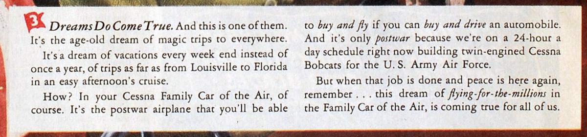
The way it was ... and (for General Aviation) the way it's gonna be, just as soon as the war is won:

"... this dream of flying-for-the-millions in the Family Car of the Air, is coming true for all of us."
Yep ... a pilot in every home.
-
2
-
1
-
-
And, since the YouTube algorithm reckons that too many Constellation films are never enough, this one has just turned up.
It's a recently made detailed analysis of the New York midair disaster of 1960.
It's the accident that was referred to, in the film above, as the last nail in the coffin of the Connie's illustrious career
(despite the fact that the aircraft, itself, was not, in any way, to blame).
-
And there's this comprehensive (if très romantique) french documentary about the Constellation.
(has english Closed Captions)
"Imagined by billionaire multi-talented genius Howard Hughes, the Constellation made an impression. A mythical airliner built by the American Lockheed, it remained the emblem of an era when air transport was a real luxury. Requisitioned by the army during the Second World War, it then ensured many transatlantic connections for a very wealthy clientele, ready to pay the equivalent of 10,000 euros for a ticket. The arrival of jet planes, and especially the 707 put into service by Boeing in 1958, marked the abrupt end of the Constellation. Actor Tchéky Karyo lends his voice to tell the story of this “air star”."
-
4
-
-
'The daily "chores" of Royal Air Force Ground Crews, Flight Riggers, Flight Mechanics and Wireless Electricians needed to keep Supermarine Spitfires operational are detailed in this 1940 instructional film. It features close-up footage of aircraft and crew from 609 Squadron at RAF Northolt undertaking the maintenance schedule required for a Spitfire Mk I's Periodical Inspection Certificate.'
-
4
-
-
-
-
This one has no chopper noise spoiling the audio:
-
3
-
-
-
8 minutes ago, Student Pilot said:
Good afternoon Captain Garry. How many words does it take the relevant Australian rule/law/ regulation to say the same thing? Are the legal consequences similar in both countries? I can't be bothered looking it up I am enjoying the day too much.
Hey there, SP ... well, at least in the user friendly VFRG the local rule is just as brief but doesn't say quite the same thing. In Oz we don't get that "sparsely populated areas" exception (other than with a low-level endo and a swag of other conditions which do take a couple more pages to clarify).
https://www.casa.gov.au/sites/default/files/2022-02/visual-flight-rules-guide.pdf (p.47-50)
Minimum height rules – other areas (CASR 91.267) (MOS 12.02)
When flying over an area that is not a populous area or public gathering (CASR 91.265), you must not fly an aircraft below 500 ft above the highest feature or obstacle within a horizontal radius of 300 m of the point on the ground or water immediately below the aircraft.
-
21 hours ago, spenaroo said:
not that it makes a difference,
But anyone know what the laws are in the USA about low flying.
I believe this is the relevant rule in the US:§ 91.119 Minimum safe altitudes: General.(c) Over other than congested areas. An altitude of 500 feet above the surface, except over open water or sparsely populated areas. In those cases, the aircraft may not be operated closer than 500 feet to any person, vessel, vehicle, or structure. /// ..... etc. -
Yeah ... hopefully - in post - shots from the chopper will be combined with the static cam stuff plus some on-board angles and then righteous roars will replace those ruined raws.
-
 1
1
-
-
-
This near miss was seen as another simple Notam fail (among other failures):
-
1
-
1
-
-
From the Original Post:
Last year I wrote to OzRwys support about the way NOTAMs are handled in their SmartBrief feature: "I’m curious about how and by-whom Notams get selected/ordered? Is there a way around having to wade through tons of dross to get to the few morsels that matter?"
OzRwys reply: '"This is because NOTAMs are very poorly sorted by the authorities (currently under a big review by CASA) and we are not given geographical information to link them more logically for users."
So today's announcement does look like real progress:
Introducing OzRunways v12 Graphical NOTAMs.
Let’s face it, NOTAMs are broken; too many nonsense ones hiding the ones that matter and impeding flight safety, not enhancing it.We've solved the problem by extracting geolocation data for every NOTAM in Australia & New Zealand. OzRunways iOS Premium subscribers can now visualise, filter, and easily read only the NOTAMs and airspace that actually affect you, making OzRunways the ultimate briefing tool.Category FilteringUsing the buttons on the right of SmartBrief, you can filter out the NOTAM categories that do not affect you, or hide individual NOTAMs completely.
Only See What's Route-SpecificNOTAMs for plan now only show those that actually intersect your track (+/- 5NM), rather than the entire briefing area, reducing the number to read by around 80%.
Trust Restricted AirspacesAll restricted airspaces, including NOTAMs, are now intelligently merged onto SmartBrief and the main map. See exactly what you can fly through with confidence in the size, status, and activation time. This airspace information is saved and available offline.
Dynamic Activation TimesAirspace activation times are now more detailed, including amendments by NOTAM. Use the SmartBrief time slider to work out whether the activation time impacts your flight. Human-readable activation times make them easier to read.
Importance FilteringNOTAMs are ranked based on their type and importance. For example: runway or airport closures are automatically assigned as ★★★★★ and are highlighted on the map.
Plain-English TranslationUsing AI text decoding, NOTAMs with unfamiliar acronyms can be translated into human-readable summaries.
Version 12 is rolling out to devices and if you have automatic updates enabled, it should install within a few days. If you want v12 now, simply locate OzRunways on the App Store and tap update. Make sure you're also running iOS 15+ or above by updating your software in device settings.Droids haven’t been forgotten!
We’ve been working hard on RWY for Android adding features such as ScratchPad and Dark Mode for maps recently. We'll be bringing better NOTAMs to RWY as well in 2024. See the latest RWY Release Notes here.VFR Standard subscriber?
Upgrade to Premium to access this feature and so much more! If you're mid-way through your subscription, we'll calculate pro-rata - winning!
© 2023 OzRunwaysOur mailing address is:
OzRunways Pty Ltd
PO Box 1374, Castle Hill, NSW 1765You are receiving this email because you signed up via our website, inside the app, or have a paid subscription.
Unsubscribe | Manage Preferences
-
1
-
 1
1
-
-
5 hours ago, tafisama said:
An Altimeter is the primary reference instrument for altitude.An EFB is not even a secondary instrument,it`s just for situational awareness.This pilot should have remembered that.He was reckless to reference to his EFB.
Yes, I don't think you'd get much argument there, least of all from the pilot involved who was very willing to share his shame for the common good.
-
1
-
-
-
Just in, some high quality info from Rowan:
From: OzRunways Support <[email protected]>Subject: RE: Altitude information from SE2 (and other devices). [Ticket#2514411]Date: 5 November 2023 at 6:30:14 am GMT+1To: xxxxxHi Gary,Yes all of the above is correct but there's a few more variables which is baro devices inside cockpits are inherently unreliable (see: all warnings about using Alternate Static Sources which usually pick up from inside). For most aircraft that's around +/- 200ft, and if you're in a pressurised aircraft, it's dramatically incorrect.It gets more complicated quickly. The GPS ALT your device(s) provide, often give altitude above the WGS84 datum, which is a mathematical shape that very closely approximates earth to within more or less +/- 200 ft. The reason is that some parts of earth are more/less dense, and there are variations in shape at these points. There is a correction model that corrects for these points, and the one we have built into the app is called EGM96 where we store all values in a 1 Degree resolution. (Interestingly, we also need to correct the NASA SRTM data for this too, as they are based on WGS84 datum).OK so it also turns out that the iPad GPS internally already corrects for Geoid corrections using their own high resolution model, similar to EGM96. So the "GPS ALT" your iPad reports, is actually already surprisingly very close to AMSL (i.e. your altimeter with correct QNH set).So for those portable devices that report your altitude based on GPS ALT (WGS84 and/or Baro Alt), we have a very complex set of rules in-app to work out which one yours is based on, try to correct for local QNH (if known), and try to work out if you're in a pressurised aircraft, etc. It's quite complex and hurts my brain whenever I have to look it up again so I won't do it now, but suffice to say, we've factored it all in, so we compare "like for like" with traffic calculations, so "+015" means "1500 ft above you", to within a decent confidence level.The GPS ALT HUD Box at the top will be reporting whatever GPS Source your iPad is using. This is outside of our control or knowledge. If it's using the internal GPS, it's likely fairly close to AMSL. If it's an external GPS, it may be WGS84 Datum altitude (i.e. a little incorrect).Anyway my final comment is you should always use your aircraft panel altimeter, with the correct QNH set, for everything related to your aircraft's flight. Don't use the iPad GPS or any portable GPS for anything other than broad situational awareness as they aren't certified, or accurate (plus, see above for the complexity involved!).Cheers, Rowan-
2
-
3
-


SkyEcho 2 fixed mount
in Instruments, Radios and Electronics
Posted · Edited by Garfly
And I guess that Brendan would do well to hold on to the old Garmin Mode C to use together with the SkyEcho2, no?
A 'proper' transponder (even an oldie) allows you to operate in Class E and is needed for any Class C transit/entry which one day (soon?) may be more relevant for RAAus craft than it is now.