PaulN
-
Posts
662 -
Joined
-
Last visited
Content Type
Profiles
Forums
Gallery
Downloads
Blogs
Events
Store
Aircraft
Resources
Tutorials
Articles
Classifieds
Movies
Books
Community Map
Quizzes
Videos Directory
Everything posted by PaulN
-
Peter, Take a look at http://www.flightdesign.com/ , click on "configurator" for prices and options/accessories in Euros. Did the Euro figure by 0.6 to get an idea of the A$ value. Paul
-
Do you mean Warnervale? I note that Aeropelican strip is also for sale. Now that one would be perfect for an airpark development ... scenic location, good climate, close to transport, all services available. Anyone out there interested in forming a syndicate to raise the $2.5m required to buy and a further $1m or so to develop? What bit do you mean ... (a) - the forum buying the strip? (b) - Gwen and I as caretakers? © - moving to the area? (a) Wistful thinking. Ian would want to fund it all on our behalf ;). That's probably his secret reason for visiting this weekend. (b) That would depend on how much caring was required and how much taking we could get away with. © A real possibility. We are about to head up that way in a couple of weeks to sus out the real estate situation with view to relocating. Paul (Better be careful not to hijack Ian's post or might delete us )
-
Ian, Dare I say it ... if this weekend is your only opportunity, it may be quicker and safer (no time/weather pressure) to go commercial to Port and fly the Gazelle down to Camden Haven and back. At around $600 return on Qantas it's not a great deal more than solo ... but way less enjoyment . Paul
-
Hi JL, Is this a requirement or a personal precautionary courtesy? I'm not aware of any stipulation on this one. And, on what frequency? Paul
-
Ian, Even when Willy is not active the restricted areas are H24, except for R583B which is advised by NOTAM. So staying within the specified route is pretty much it. The VTC shows the levels for that VFR route as SFC/1000 AMSL for the southern half (D589A) and SFC/1500 AMSL for the northern half (D589B) so it's all low level around 1000' AGL (give or take a few hundred feet here and there). If it's variety you're after, maybe you can fly UNDER the occasional railway bridge :ah_oh:. With narrow lanes like this and V1 you should always aim to keep to the right of the lane and hope that any oncoming traffic knows the correct procedure too. Head-on traffic should pass on each other's LHS, that is, he should be on your left and you should be on his left. The ERSA details the lane widths for you. Good idea to switch on your "landing light" too. Don't forget to listen out and make your over-fly call for Gloucester on 126.7. Keep you're fingers crossed that there's no wind as you fly this section or turb will be your friend all the way :yuk:. Enjoy, Paul PS maybe you could take a pic as you pass over Pylon500's "work-in-progress" at YTRE as you go over. He might appreciate a progress report.
-
Darn right Geoff. Without an idea of your route I'm stumped with these ;). Great shots though. Did you catch any fish this time? Paul
-
Good news indeed Steven. Well done . Wise words too ;). Paul
-
The revised route looks good Ian. Good advice Mike. Keep a sharp eye out for oncoming traffic along that low level VFR route along the railway around the back of Willy. Hope the weather holds out and the winds chase you both ways. Looking at the forecasts you may have trouble getting home on Monday. Keep an eye on it. Now, let's see if you can do it without the GPS and AP. And, I bet you can't fit 130 litres in those tanks. Our CT overflows just as we get to 120 litres, and that's from known empty, right down to the gascolator. Safe flying, Paul
-
No, not LR BigPete. That's Coober Pedy from what I remember of it. The other's ... hmmm. Better get the WACs and ERSA out. Standby Geoff, I'll be back. Paul
-
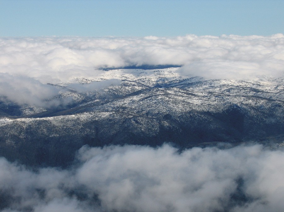
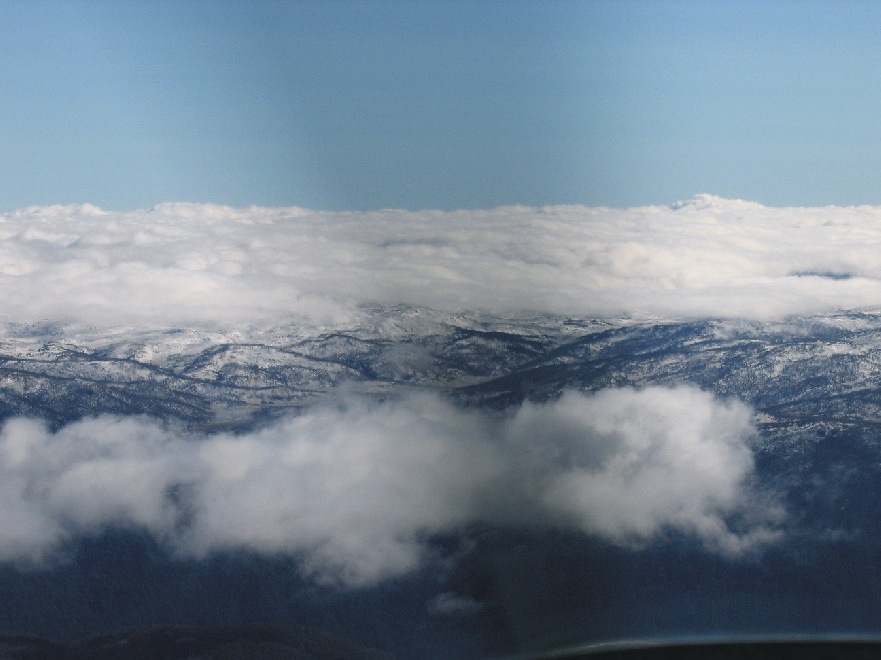
Thanks. Not all that cold Chris, didn't even need the cabin heat on (8 degrees OAT and 17 degrees inside at 9500').
-
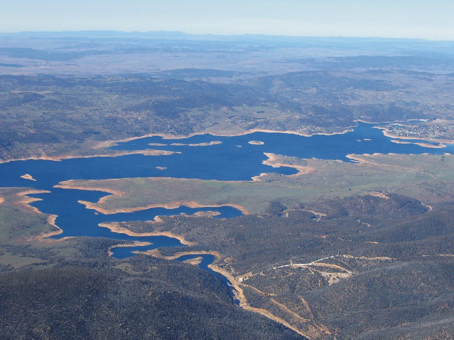
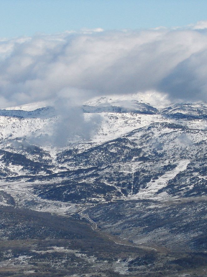
Not really. One better. Went flying to see the first snow of the season. Not bad for May ;). Just 12 minutes from take-off these shots were taken at 9500' showing "low" cloud sitting on the range. Although negligible wind not really suitable to over-fly today. The first shot is Lake Jindabyne viewed from the NW and the last shot is looking over Smiggin Holes ski fields. Interesting, on 126.7 I could listen-out on chatter from Naranderra about 145nm NW. Paul

-

New Nest needed! Do vampires nest?
PaulN replied to Ultralights's topic in AUS/NZ General Discussion
Hey Rob, Does this mean we can come to you for our composite repair work? ;) Paul -
Back in your early school days Chris? ;)
-
Doug, I'm probably stating the obvious, but ... Another map you'll need to refer to, but not necessarliy in flight, is the ERC-Low chart. This is where we find radio frequencies needed en route. I make it a practice to note all relevant frequency changes (even those to just listen-out on while passing nearby strips) on my flight plan in such a way that they are obvious and timely. Plan ahead and set the next frequency into stand-by as you switch channels. Also on my flight plan I note relevant ATIS and Flight Watch frequencies and use Flight Watch for weather updates. Hope this helps, Paul
-
Thanks for sharing that Mike. An excellent article and one that has got me thinking about my own decisions. I hope everyone takes the time to read this and make an honest appraisal of his/her PIC responsibilities. Again, thank you. Paul
-
Heh, heh. I knew when I read the wx reports this morning someone from The Oaks would post something about it. Thanks for not disappointing Darren ;). We had great conditions here at Cooma this morning before the front came through ... could even have a windscreen wash as you flew along at 500 agl. No, I didn't . Paul
-
I second Ian's comments re DG and fluid compass. Our little birdies do bounce about at times. Re GPS failure, mine has dropped out 3 times since Dec 2004. As Murphy would have it, each time was smack over the top of tiger stuff but only for about 30 seconds. Strangely, it failed on two well separated occasions in the same location midway between Tumut and Cooma. Each time this has happened, intuitively my eye went straight to the compass to confirm my bearing then back to the flt plan to check the drift and all was well. It's so easy to become dependent of these gadgets. Paul
-
Did it have any colours/graphics Kyle? Did you happen to get the numbers? That might help us narrow the search a bit. I know who it was not ... me. Paul
-
Cazza, My request was a tongue-in-cheek early reservation for the forum fly-in (sometime) that you suggested ;). Paul
-
Hi Doug, Use the protractor and nav computer. During your training and for the first 100 - 200 hours of XC flying don't even think about flight planning software, just pretend they don't exist. It's not only an interesting and satisfying accomplishment to master these tools but a pretty darn important part of your pilot skills. Sure you'll make mistakes, as we all do, that's why it's important to check and recheck your calcs before commiting to flight. I reckon if you're committed to learning to fly you should make every effort to master the required skills to a proficient pilot without needing to fall back on IT stuff. Yeah, I know, there will come a day as skills progress in line with technology that the old "mechanical" ways will pass by the way ... not many of us use an abacus anymore. But you and I are in the transition phase now, so apply your skills in line with your training syllabus until all that changes. It'll be interesting to see what other views may come of this. Paul
-
Hi Don, We have a sock at each end of the 2120m runway here at Cooma and it's not unusual, in fact more usual, to see them indicating differently. The wind will always be affected by terrain and man made obstacles. The degree and resultant effects will change with the dominant air flow (wind direction). As air is fluid, we can liken it to water flowing in a stream. Place an object (rock, stick, whatever) into a part that appears to be flowing smoothly in the down stream direction and you will see the direction of flow alter, at least in the vicinity of the object. Make the object bigger and the effect will be greater and more widespread. Place a number of objects in random spots and the flow is all over the place while still generally heading downstream. Added to this is the eddy effect around some objects causing the flow to momentarily head upstream as it swirls around like a mild whirlpool. Also worth considering is the drag effect that the ground surface has on air flow. Say the lower level atmospheric wind is flowing north to south (northerly). Close to the ground the drag effect of the surface, even a substantially flat and smoothe surface, will cause a directional variation of the wind, say NNE or NNW, and sometimes more acute directional changes. Hope this helps, Paul
-
Then we might have had restrictions imposed down our way ... no thanks, Sydney's good.
-
Sounds like a great idea Carol. Can I pencil-in a reservation for 2 for the B&B for that weekend now? Paul
-
And they're talking about giving Sydney-ites a holiday for the event. That should quell the whining :;)4:.
-
First you identified yourself as "late in life" and now "suffering old age". Give us break Cazza, if a young chick like you is thinking "old", where does that leave us retired old farts? I just wish I was your age again, know as much as you do, and already discovered the delights of flight as you have. You're a rare breed, and your aviator buddies are impressed. Paul