kiwiaviator
-
Posts
166 -
Joined
-
Last visited
-
Days Won
6
Content Type
Profiles
Forums
Gallery
Downloads
Blogs
Events
Store
Aircraft
Resources
Tutorials
Articles
Classifieds
Movies
Books
Community Map
Quizzes
Videos Directory
Everything posted by kiwiaviator
-
I have the same one on my 230 Glen. Great covers and yes, I have the side straps around the main spring.
-
QC is so important. We manufacture a valve used for mining sample analysis which uses a 50x3 O-ring on the piston. All of a sudden we were having valve failures. The o-ring supplier had decided that an imperial size close to the metric one was ok to supply without advising us. We now check every o-ring and seal. I would hope that aircraft engine manufacturers have a very robust QC system. It would be interesting to see what the o-ring material spec on the Gen 4 is? Good pick up Glen.
-
Finally got to install the LED kit you sent me Glen. Works a treat. Thank you 🙂
-

Apple Watch E6B App
kiwiaviator replied to kiwiaviator's topic in Instruments, Radios and Electronics
Update from Sportys. Changing settings on the Apple Watch is not possible. God bless America and their inches of mercury..... -
Apple Watch E6B App
kiwiaviator replied to kiwiaviator's topic in Instruments, Radios and Electronics
Thanks onetrack however that's a different app. I'm using Sportys E6B with an Apple Watch. Apparently they fixed this issue in 2011 butI can't find anywhere to change settings? -
Is anyone using the Sportys E6B app on an Apple Watch 3? I can't get the pressure setting to change from inHg to mB. No issues on the iPhone that the watch is synced to.
-
Amazing they managed to crawl out of this! https://www.nzherald.co.nz/nz/emergency-services-at-scene-of-small-plane-crash-near-waimakariri-canterbury/IB2L3YEHE2AASBZJ3C5NV7B5QI/
-
Jabiru 230 Go-around
kiwiaviator replied to anjum_jabiru's topic in Student Pilot & Further Learning
I used a sideslip on my PPL flight test during the forced landing initial phase, in order to position to the field I was gunning for. The examiner was impressed that I had that extra tool in the toolbox.. -
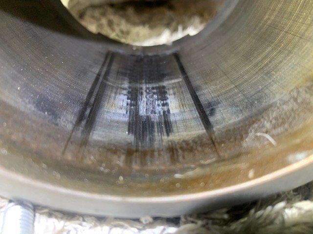
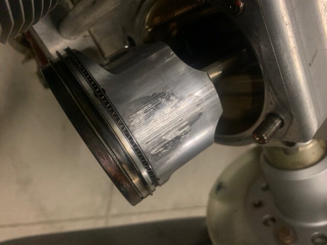
Photos I was sent last year. Gen 4 pistons in a Gen 3 engine after approx 3 hours running. Engine now has non-Jab forged pistons with no issues.

-
Fraser Island Qld - Landings
kiwiaviator replied to FlyingVizsla's topic in AUS/NZ General Discussion
Page not found with the link however I managed to find it using search. I am reading it as saying you can with approval. -
Fraser Island Qld - Landings
kiwiaviator replied to FlyingVizsla's topic in AUS/NZ General Discussion
Orchid Beach is on my bucket list. Love Fraser Island. -
Another Wairarapa Aero Club newsletter with a mix of Vampires, airshows with B-52's and Jabs in WA. https://mailchi.mp/0ebfdd79f6e5/latest-aero-club-news-1758000
-
- 4
-

-
It will be interesting to see if CASA issues any guidance with respect to NZ PPL holders wanting to fly in Australia after the changes.
-
The PPL privileges table from 5 April 2021 https://www.aviation.govt.nz/licensing-and-certification/pilots/pilot-licensing/ppl-privileges-by-type-of-medical-certificate
-
Great news for NZ PPL/RPL holders. These changes were made after considerable consultation with stakeholders and the regulator (CAA) is to be applauded for taking on the feedback provided. There were some significant concessions made after the draft release. https://www.aviation.govt.nz/about-us/media-releases/show/New-medical-standard-to-make-flying-more-accessible
-
Middle Earth Peter?
-
Satellite Laser Ranging Station WA
kiwiaviator replied to kiwiaviator's topic in AUS/NZ General Discussion
Yep. Shows up on the ERC-L chart. I'll refer to this a bit more often. There is a lot of information out there. Its just a matter of finding where it lurks. Thanks guys. -
Satellite Laser Ranging Station WA
kiwiaviator replied to kiwiaviator's topic in AUS/NZ General Discussion
OK. Looking at my Ozrunways map, I can not see any notation referring to R131A-G. Where would I find that information including step heights PapaFox? Apologies if this is obvious to all except me. I would have thought the R designation would be on the map. PS. NAIPS doesn't give the step info. -
I have been told that the red 'blob' on the attached map near Geraldton is a satellite laser ranging station. Not a lot of info on it that I can find except for this at https://www.ga.gov.au/scientific-topics/positioning-navigation/geodesy/geodetic-techniques/satellite-laser-ranging-slr Does anyone have any references as to how one should transit/avoid this airspace? There doesn't appear to be any associated notes and its not R nor D airspace? Is it NOTAM activated? Even a 'WARNING - Deathstar may operate at any time' note would be helpful. In the meantime, I'm staying away from the red blob..
-
24 Registered Maintenance Schedule Latitude
kiwiaviator replied to kiwiaviator's topic in Aircraft General Discussion
Thanks all. I think the picture is a bit clearer in my head now. -
24 Registered Maintenance Schedule Latitude
kiwiaviator replied to kiwiaviator's topic in Aircraft General Discussion
Absolutely old man emu. Its just that I can't find any guidance on the tolerances for RAAus registered aircraft. -
24 Registered Maintenance Schedule Latitude
kiwiaviator replied to kiwiaviator's topic in Aircraft General Discussion
Thanks for your input skippydiesel. Agree on the non cumulative. Behind the curve in anything is not a good spot. -
Definitely got the Osram Glen. You must have a pretty good spectrum analyzer or your 230 didn't cost much 🙂 Look forward to what you find out. Kev
-
I finally got around to installing this. (Doesn't help when you live 1200kms away from your aircraft. Does anyone have any hanger space in Newman?!) Works great from a brightness and power draw perspective however it unmutes the radios something chronic. Guessing I should start chasing earthing?
-
I have been searching for a definitive statement on maintenance schedule latitude for 24 registered aircraft. My experience in the Eastern Isles (NZ) was 10% ie. on a 50 hr you can go out to 55 hours however its not cumulative. Does anyone know what the story is here in the western isle? The RAAus Technical Manual doesn't appear to mention it. Cheers.