Old Koreelah Posted December 16, 2020 Posted December 16, 2020 Cutting that airstrip and making all those gardens on precipitous slopes mean those people are no strangers to hard work.
onetrack Posted December 17, 2020 Posted December 17, 2020 Old K - I'd hazard a guess that that airstrip would quite likely have been cut with the assistance of air-droppable American military construction equipment during WW2 - such as the Clarkair CA-1 bulldozer. Small towed earthmoving scoops and even towed graders were airdropped at the same time, giving U.S. Aviation Engineers the ability to shift sizeable volumes of dirt - all aided by local labour as well. 1
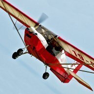
Garfly Posted December 17, 2020 Author Posted December 17, 2020 Another wheel, another ridge ... same amazing beauty. 2 1
poteroo Posted December 25, 2020 Posted December 25, 2020 On 17/12/2020 at 9:40 AM, onetrack said: Old K - I'd hazard a guess that that airstrip would quite likely have been cut with the assistance of air-droppable American military construction equipment during WW2 - such as the Clarkair CA-1 bulldozer. Small towed earthmoving scoops and even towed graders were airdropped at the same time, giving U.S. Aviation Engineers the ability to shift sizeable volumes of dirt - all aided by local labour as well. I flew into Wabag, Wapenamunda and Mt Hagen when posted to Hagen in 1961 and it was quite a place. Places like Maramuni would not have been built until at least the late 60's so unlikely to have been any mechanised help. The Yanks reportedly did do some work on the emergency strip at Bena Bena, (near present day Goroka), and apparently the Japanese aerial searched for this strip - but due weather, they never located it. In the 60's, in the Enga region, the patrol posts of Kompiam, Laiagam, Tambul were just being built, as were a few 'mission'strips which were mostly serviced by MAF using C180/185 types. Maramuni is located on the north 'face' of the highlands, and as far as I know, the Japanese never went near the place. They pretty much kept out of the highlands proper. Wau/Bulolo and Kokoda are surely mountainous, but not the real 'highlands' as we knew it. The pic below is of Simbai, some 5700amsl in the Adelbert Ranges, from where the rivers run N to the Sepik, ie on the N side of the main highlands just a bit east of the Jimi River. happy days, 2 2
Old Koreelah Posted December 25, 2020 Posted December 25, 2020 New Guinea deserves a thread of its own, Potty. I’ve read much about the Highlands in particular, including stories of adventurous Aussies penetrating the interior to make their fortunes. Perhaps you could comment on the story that white fellas would look at the rugged interior from both north and south and assume they were the same mountains. WWII brought lots of aircraft to the area, and pilots discovered large highland valleys and an entire culture not previously contacted.
Jase T Posted December 25, 2020 Posted December 25, 2020 Now I will have to look. I have a photo from my time on Bougainville with the ALT reading 10 000 feet and the RADALT reading 50 feet! Want to learn how to fly in high DA PNG is your place!!
poteroo Posted December 26, 2020 Posted December 26, 2020 12 hours ago, Old Koreelah said: New Guinea deserves a thread of its own, Potty. I’ve read much about the Highlands in particular, including stories of adventurous Aussies penetrating the interior to make their fortunes. Perhaps you could comment on the story that white fellas would look at the rugged interior from both north and south and assume they were the same mountains. WWII brought lots of aircraft to the area, and pilots discovered large highland valleys and an entire culture not previously contacted. The Leahey brothers walked into the main highlands, (the Wahgi Valley) in 1936. Beyond there it remained pretty much unexplored until after WW2. I was fortunate enough to have been posted to Mt Hagen, (as a 'didiman' in 1961), and lived on the Dept of Ag Research Station at Korn Farm - about 10nm SE of the main Mt Hagen township of approx 50 Europeans. (see pic). I supervised a 'line' of local warriors when the current Kagamuga / Mt Hagen airstrip was cleared of bush in August 1961. When it was burnt off, to the sound of thousands of whooops by the locals, the smoke filled the entire Wahgi valley for 2 days or more and inbound DC3 pilots reported IFR! The old 'town' strip has long since been built over. The new airport was still pretty basic when we last saw it during our departure from the Hagen Show in Sept 1969, (see pic of wet and gloomy wx). for a nervous 'VFR' flight back over the hills to Port Moresby - took 2.5 hrs if I remember, including several diversions, and a climb to 14,000 to squeek thru. The pic of the USAF wreckage on the side of Mt Wilhelm, (14,000'), was possibly a result of IFR flying when we've since heard that the maps they used understated the tops of most PNG peaks by over 1000' The pic of Tabibuga, (Jimi River), is just over the north wall of the Waghi valley, on the north face of the main ranges, and from where the river runs north to join the mighty Sepik. Not worth a thread on this site as there is already a huge thread on pprune if anyone wants to look at that. It was vg in the beginning, but has developed into a bit of a personality thing, as 99% of the followers have long since left PNG. Old farts just rehashing, and enhancing, their youthful adventures. There are a load of 'lessons-to-be-learnt' from the flying up there, but in Australia, it boils down to: 1. Keep out of cloud 2. Don't overload 3. Carry much more fuel than you think needed 4. Learn how to handle your aircraft at low speeds. 5. Keep out of cloud. 6. Keep out of cloud......... happy days, 4 1 1
cooperplace Posted December 29, 2020 Posted December 29, 2020 My uncle flew Beaufighters and Kittyhawks in PNG in 1944-45, and he said he was sh1t-scared the whole time, that it was probably the toughest aviation country on Earth. He was only 18 when he arrived there. He survived the war and swore to never fly a plane again, an oath he kept. 1
Recommended Posts
Create an account or sign in to comment
You need to be a member in order to leave a comment
Create an account
Sign up for a new account in our community. It's easy!
Register a new accountSign in
Already have an account? Sign in here.
Sign In Now