dsam
-
Posts
493 -
Joined
-
Last visited
-
Days Won
4
Content Type
Profiles
Forums
Gallery
Downloads
Blogs
Events
Store
Aircraft
Resources
Tutorials
Articles
Classifieds
Movies
Books
Community Map
Quizzes
Videos Directory
Everything posted by dsam
-
I can only hope this is just the first step in establishing a broader endorsement process for suitably equipped & maintained aircraft and RPC pilots achieving a sensible endorsement for this. It has been a long time since this was proposed, and I’ve been very keen to see it become fully available. I only hope it doesn’t take an impossibly long time to get to the next step
-
I've had some prompt and helpful responses from both RA-Aus, and the military people of East Sale. So yes, from the "RAAF BASE EAST SALE LOCAL AIRSPACE PAMPHLET", "Aircraft must monitor 126.7MHz and broadcast at Cowwarr and Lindenow South compulsory en-route reporting points" So it seems as a pilot with an RPC, I can transit D353 at 1500ft despite R358A remaining active SFC to FL450, provided I report at the reporting points (as per the .pdf) W1125274.pdf W1125274.pdf W1125274.pdf
-
If in the future they open up other corridors to West Sale (Princes Route) and the Coastal Route (as has been suggested earlier in this thread), there would be further segments involved (H I J...) or as a simpler alternative, the military can simply keep above 1500 when outside their Military CTR. That shouldn't be too hard for their high performance aircraft. Then again, CASA could hurry up and "get on with it" and grant transit rights to RA-Aus RPC pilots along the designated VFR corridors used by RPL flyers now.
-
Hi Vev, I'm just a recreational pilot, not an airspace designer, but I would have thought the best implementation would have been: R358A should now start from 1500FT to FL450 (ie not from SFC) R358F would be SFC to 1500FT (south of VFR corridor) R358G would be SFC to 1500FT (north of VFR corridor) That would resolve any confusion in the NOTAMS, - and for the military pilots hammering along at low level everywhere else As it reads currently, you would need ATC clearance to transit through RA1 along that corridor due to R358A extending to the surface. As an RA-Aus pilot, I am not permitted to request such a clearance.
-
OK, so here is today's NOTAM info on ESX As I read it, how can both R358A (with its current boundaries) and D353 be active at the same times? R358A shows SFC to FL450 which would necessarily include SFC to 1500FT AMSL! Wouldn't that logically make D353 inactive along its corridor? When I use OzRunways to plot a flight plan through the corridor at 1500ft, It still shows I'm attempting to transit R353A (RA1) Surely to be clearer R358A will need to be split as perhaps R358F and R358G to designate areas north and south of this corridor to avoid confusion? I'd be happy for anybody to enlighten me on this....! _____________________________ EAST SALE AIRSPACE (ESX) C271/18 REVIEW C267/18 D353 ACT SFC TO 1500FT AMSL FROM 05 300807 TO 06 010400 1805300807 TO 1805300900 1805302200 TO 1805311200 1805312200 TO 1806010400 C268/18 REVIEW C264/18 R358A ACT (RA1) SFC TO FL450 FROM 05 300807 TO 06 010400 1805300807 TO 1805300900 1805302200 TO 1805311200 1805312200 TO 1806010400
-
I “hangar” my Eurofox in a trailer with wings folded back. My wing tanks need to be well under half full when stored this way, or I can sometimes get fuel leakage out the top vents. I always buy fresh Shell 98 from a high volume retailer on my way to the airfield. I’m told that in Victoria they don’t use ethanol in their 98. I’ve had no issues in the last 6 years doing this.
-
I plan my recreational outback flights with 45 minutes reserve, and a 10% variable reserve (due to the winds aloft “forecast” issue mentioned by Jabba-who). My Dynon Skyview gives me real-time data on wind & direction right from my initial climb all the way to my planned cruising altitude. I write this “measured wind” data down for each valid cruise altitude for my intended track. I find that 10% wind variation applies quite often, and I regularly choose a different, more favourable altitude to the one from the forecast. Throughout my flight the Dynon reports calculated range in real-time (ie allowing for actual wind & measured fuel flow). I’ve never found myself caught out with fuel range & reserve issues thanks to all this technology (and yes I fly with considerable redundancy in this technology). I also have a visable tube showing the fuel level of each wing tank for absolute certainty, so the Dynon could fail and I still know what is going on with fuel levels. Yes the old fashioned tried-and true ways can work as well, but I prefer the accuracy and labour saving of all my modern devices.
-
Oops, yes I’m commenting 4 days ahead of the D353 opening date... still keen to hear from aviators using that corridor when it is available☺️
-

FREE Australian Airport Database for Dynon SkyView
dsam replied to KRviator's topic in AUS/NZ General Discussion
Great! Thanks KRviator. I'll have a go at uploading this dataset sometime over the next couple weeks and let you know if there are any issues. Much appreciated! -
OK so D353 VFR transit corridor across the East Sale military airspace is now available. It will be interesting to hear from RA-Aus pilots if this is working as planned. As for RA-Aus getting overall CTA endorsement/transit/access, I got a response from RA-Aus 2 days ago... no surprises.... All we get is the sound of (bureaucratic) crickets from CASA!! How frustrating...!
-
The folks at Lethbridge (YLED) have a fine new fuel setup that includes a ULP bowser. Perhaps contact them with your questions...
-
Airframe Mounted EPIRB Actually Works
dsam replied to Flying Binghi's topic in Aircraft Incidents and Accidents
I probably take the record for flying with the most tracking/rescue devices: GPS enabled PLB, SPOT tracker, Portable VHF radio, OzRunways, AvPlan, ADSB-out transponder, & Apple’s “find my phone”!! Now I just have to hope that anybody would want to find me -
So I see that the 24th May Airservices maps now show the VFR transit corridor D353. It’s a welcome addition for this sightseeing RA-Aus aviator, but I would really like to see the coastal corridor opened up too! I’m sure the West Sale RA-Aus aviators are especially keen for a similar solution to their airspace issues too Any updates from the military? Similarly, I’ve heard no updates from RA-Aus regarding the CTA endorsement either!
-
Quite correct. That’s why I used the plural... “wind directionS” in my comment. The glide ring tells you what paddocks to look for, and your ongoing vigilance watches for smoke trails, dust plumes behind farm equipment, ripples on dam water, etc. throughout your journey.
-
OzRunways had this glide-ring feature several versions ago, but they dropped it... perhaps they were worried of legal action?? AvPlan does still have this, but like the Dynon, you need to enter your aircraft glide speed & glide ratio data correctly. AvPlan’s glide ring allows for terrain & altitude, but unlike the Dynon, I don’t think it has accurate compensation for actual calculated wind aloft. I’m happy to be corrected on this Bevan...
-
My 15 year old self watched a draggy 2 seater training glider stall & cartwheel into a paddock trying to stretch a glide over a dirt road & telephone wire back to the airfield. They luckily only had minor injuries, but it left an indelible impression on me, especially as I was scheduled as the next student to fly in that (now wrecked) glider! Far better would have been if they had recognised they set up the circuit too low, and made the decision early to land short in the (perfectly usable) stubble field short of final!
-
Somewhat relevant to this topic - The Dynon Skyview displays a “glide ring” over the Airservices moving map display. It offsets according to wind aloft, and is terrain & altitude aware, for flights over the high country. If you should encounter engine failure enroute, you know instantly what is in range for your glide. I always keep an eye on this glide ring, noting potential forced landing sites & wind directions as I fly.
-
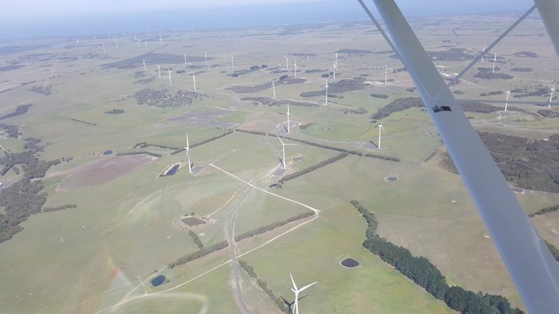
There’s a lovely cluster of windmill towers at Venus Bay Vic. just off the Bass Straight. I often plan a local flight past here, and along the fabulous coastline back to Phillip Island. I’ve never been able to figure out why the mandatory design standard doesn’t require storage batteries at the base of each tower, and a bank of solar panels down the north side of each tower!

-
Rasberry Pi ADS-B receiver experiences?
dsam replied to Bleve97's topic in Instruments, Radios and Electronics
Yes, and with eyeballs frantically scanning outside looking for all the “paints” we were blissfully unaware of previously! -
Rasberry Pi ADS-B receiver experiences?
dsam replied to Bleve97's topic in Instruments, Radios and Electronics
Bevan, I’m aware of your ongoing positive approach to this, and I continue to thank you for your efforts. It’s disappointing that you only get silence from the other EFB developer. Their inaction on this also speaks volumes. Ideally, an enlightened and proactive regulator with safety truly at the heart of its actions would have attempted to support both EFB suppliers with the integration of traffic data along with Airservices ADSB paints, so all users had all traffic data available as an aid to situational awareness. I suppose my idealism (yes another “ism” in my list) isn’t rewarded across the aviation community as strongly as you and I would like to see. -
AirVenture Australia is landing in Cessnock this September
dsam posted a topic in Trips/Events/Seats
New venue... anybody with any insights or comments on this? -
Rasberry Pi ADS-B receiver experiences?
dsam replied to Bleve97's topic in Instruments, Radios and Electronics
When litigation "a$$ covering" apparently comes ahead of "Safety" which is CASA's prime focus (according to their founding Act of Parliament), their (in)actions speak louder than their words. -
Rasberry Pi ADS-B receiver experiences?
dsam replied to Bleve97's topic in Instruments, Radios and Electronics
Yes, maybe the "ism" we need is Activism! Write to your pollies!! Sadly, most of them couldn't even begin to understand the issues at hand.... -
Rasberry Pi ADS-B receiver experiences?
dsam replied to Bleve97's topic in Instruments, Radios and Electronics
Birdseye, you are probably right about the "rationale" of each authority, but the pragmatist in me says their mindset on this is completely wrong! Layer it with disclaimers, and "not to be relied upon" statements, but spending a mere pittance to facilitate something that could really make a big difference to situational awareness (and safety IMHO), and you've won over lots of cynics like me! -
Rasberry Pi ADS-B receiver experiences?
dsam replied to Bleve97's topic in Instruments, Radios and Electronics
All good questions. I will have a bash at it (happy to be corrected by others more knowledgeable...)1) Yes (mine is older and needs an external wifi "dongle") 2) Go to OzRunways website and get their parts list like I did. They are tiny usb "dongles" on the Raspberry Pi plus a tiny inboard antenna I leave stashed loosely in my "glovebox" in my cockpit. I am in a fabric fuselage and have no reception issues whatsoever. 3) I use the Jaycar 4x USB inserted into my "cigarette lighter" port on my instrument panel. It is high current, low RF "hash" and keeps my iPads & iPhone charged too. 4) My iPads have the "cellular" sim cards from Telstra and I have good signal coverage across most of the populated "J" regions of southeastern Australia 5) follow the instructions on the OzRunways website. It goes onto an SD card. I've used their default software 6) that is USA infrastructure... not applicable here 7) ditto 8) correct 9) correct 10) correct 11) correct (I believe). Note: lots of traffic not transmitting ADSB, so don't be complacent. Keep your eyes scanning! :-) 12) correct, unless you've paid for AvPlan and switch back and forth to their software like I do! 13) correct (note 11 above) 14) correct. I know a tech savvy twin pilot that has installed a FLARM device for situational awareness within gliding areas too! (I'm not up to that yet...) It's sad that CASA/Airservices don't facilitate integration/re-release of AvPlan/OzRunways/ADSB data for EFB pilots (note my earlier posts on this). The cynic in me tells me they really don't care about safety, otherwise it would be done by now!