Garfly
-
Posts
3,054 -
Joined
-
Last visited
-
Days Won
67
Content Type
Profiles
Forums
Gallery
Downloads
Blogs
Events
Store
Aircraft
Resources
Tutorials
Articles
Classifieds
Movies
Books
Community Map
Quizzes
Videos Directory
Everything posted by Garfly
-
Who's talking about jumping?
-
And don't get me started on the dangers of airbags.
-
No, of course not. Anyway, in a Cirrus you don't really have that choice. What the story has to do with, among other things, is if you have one do you pull the handle or go for the field. That dilemma is a little bit like whether to install or not ... except that decision time is now. 🙂
-
-
Glen, are you're saying that you think the clarification I got from RAAus (as quoted above - and, in more detail, below) is wrong - have things changed?: From: Gary .......................... Sent: Wednesday, 27 January 2021 6:31 AM To: RAAus Policy <[email protected]> Subject: Update on lowering of Class E airspace Dear RAAus team, your update today regarding the proposal to lower Class E made no mention of what seems to be a relevant implication; the CASA ‘concession’ to recreational craft to substitute relatively cheap EC (Integrated TABS) devices for TSO’d transponders in Class E. CASA ADVISORY CIRCULAR AC 91-23 v1.0 Excerpt: "Apart from an integrated TABS device able to substitute for a transponder in Class E & G airspace, lower cost options are not intended to overcome any existing requirement to carry a transponder, in any class of airspace.” I’m not saying that this makes the proposal okay, not at all; but it does appear to be part of the grand CASA strategy (and a way to dampen resistance from the VFR crowd). Anyway I’d have thought that at least some engagement wit this gambit ought to be part of any response. The SkyEcho2 device, for example, seems to qualify under this concession. As you know, it's stand-alone portable unit that can even be moved between (uniquely registered) aircraft. So carrying one may indeed overcome many of the objections we, as a group, might otherwise raise. It might even make some things better for our sector, such as clearance-free transit overhead Class D at Coffs. However, if, indeed, mandating this kind of device (at a minimum) is what CASA (in their obfuscating way) is intending, then why don’t they come out and say so? They should reveal their hand if they really want ‘consultation’. BTW, this issue has been heavily canvassed in recent days on Recreational Flying forums but it seems nobody knows for sure what’s going on. https://www.recreationalflying.com/topic/37213-lowering-class-e-between-melbourne-and-cairns/ all the best, Gary ..... (RAAus pilot/member) On 27 Jan 2021, at 6:22 pm, RAAus Policy <[email protected]> wrote: G'day Gary, Thanks so much for your email. It totally agree with your notion that as an industry, and I mean all stakeholders including the regulator, need to work together to come up with solutions that work for all, with little or no impact. Of course the EC devices are a terrific situational awareness tool however, as you'll find in CAO 20.18, these are not able to be used by ATC and therefore do not meet the requirements of transponder fitment in Class E. The safety benefits of EC devices are real for us pilots, but because of the technical standards we're told by the regulator and Airservices that the integrity of the positional source information and because of the low wattage of the SkyEcho2, for example, it's not suitable for use by ATC and therefore it's filtered out of their radar picture. Happy to discuss further. Cheers Matt Bouttell CEO RAAus From: Gary ........... Sent: Wednesday, 27 January 2021 7:45 AM To: RAAus Policy <[email protected]> Subject: Re: Update on lowering of Class E airspace Hi Matt, Thanks for getting back. So what do you make of the quote from the CASA circular that I included in my mail? They clearly say that Integrated TABS (SIL<=1) - such as a SE2 - can be substituted in Class E. Is it false? Has it been rescinded? What gives? If you have clear info that contradicts the CASA statement above then it’s urgent that we know about it. Even right now for ops in Class E. Please refer to the Rec Flying forum I mentioned. https://www.recreationalflying.com/topic/37213-lowering-class-e-between-melbourne-and-cairns/ I gather, from various CASA documents that it’s not only ATC visibility that’s in their thinking but also CDTI tech being aboard all regional RPT craft. I reckon they figure that if RPT all have ADSB-in info displayed they can take over some of their own separation responsibility in E (as they do now in G) as long as everyone in the space has some kind of conspicuity going. And, in any case, a SkyEcho2 type device is likely, in practice, to be visible to ATC in terminal areas low power notwithstanding. What say you? gary. From: RAAus Policy <[email protected]> Subject: Re: Update on lowering of Class E airspace Date: 27 January 2021 at 7:04:59 pm AEDT To: Gary ....... Hey Gary, An integrated TABS device is not an EC device, such as the SE2. These are two different things. If you take a look at CAO 20.18 Appendix XIII (for integrated TABS) or Appendix XIV (for EC device) you'll see that an integrated TABS device must meet the technical specifications for (E)TSO-C199. and have a SIL of 1. I think this raised the issue of how complex this matter is. People are confused as to the proposal but also the requirements as they stand today. We'll make mention of this to Airservices (whom I'm meeting tomorrow) and CASA at the earliest opportunity to ensure the current requirements are made clear. I hope this helps. Cheers Matt
-
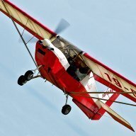 This is just a single - very nicely done - shot of a good looking RV-7A landing (leaving only light work for the little wheel).
 -
Yeah, apart from the ASIC issue, as far as I know, you can still access YTWB remaining OCTA, and avoiding the Military Romeo's most of the time. Maybe some locals could fill us in on that. I'd be interested anyway.
-
Wouldn't YTWB be able to accommodate you? Is it because it's a security controlled joint? Or your reluctance to get stuck there by pop-up PRDs? Maybe parking up at Warwick, to start with, and getting old TWB mate to come get you is the way to go. ;- ) Anyway, sounds like a nice trip.
-
Makes me feel a bit better about leaving the 'Ranger alone in the hangar for months on end.
-
LOL ... Yeah, well I guess times have moved on. (Anyway, jeans, sneakers and T's are still the go ;- )
-
Glen did you fly direct YCWR - YMND on this trip? And the northerly route you say you'd take if there was significant cloud ... do you mean like via Mudgee and Warkworth? Would you say the worst of the tiger country was pretty much the area north east of Bathurst and south west of Cessnock? They say that there are times when the Hunter Valley can get socked in for weeks with cloud sitting on the ranges to the north, south and west - even the hills to the east. I remember Old Koreelah telling us here once, that his aero club at Quirindi (on the plains north-west of Scone) offered basic accommodation to encourage visiting pilots bound for the Hunter to stay and wait it out if cumulo granitus was festooning the Liverpool Range.
-
I used to think that the SE2 would qualify us to use Class E. I was encouraged by this: CASA ADVISORY CIRCULAR AC 91-23 v1.0 Excerpt: "Apart from an integrated TABS device able to substitute for a transponder in Class E & G airspace, lower cost options are not intended to overcome any existing requirement to carry a transponder, in any class of airspace.” But on seeking clarification from RAAus I got this response from their Policy section: "An integrated TABS device is not an EC device, such as the SE2. These are two different things. If you take a look at CAO 20.18 Appendix XIII (for integrated TABS) or Appendix XIV (for EC device) you'll see that an integrated TABS device must meet the technical specifications for (E)TSO-C199. and have a SIL of 1." We had a fairly long discussion about this on here a couple of years ago when there was an Airservices Australia proposal to lower the Class E space over much of eastern Oz. https://www.recreationalflying.com/topic/37213-lowering-class-e-between-melbourne-and-cairns/
-
Jim Tweto, bush pilot of ‘Flying Wild Alaska,’ dies in plane crash - The Washington Post WWW.WASHINGTONPOST.COM Jim Tweto, star of the Discovery Channel's "Flying Wild Alaska," has died in a plane crash, along with his passenger, Idaho outdoor guide Shane Reynolds. In this clip from "Flying Wild Alaska" Jim Tweeto bemoans the high fatal accident numbers in Alaskan flying - back then. (And he suffers a broken rudder on take off.)
-
Meanwhile, back at Amberley:
-
This is another oddity from the airline archive. Alistair Cooke, of all people, is our presenter for this TV film about the latest in air safety procedures. The 'talk 'em down the glideslope' ILS procedure at Idlewild is interesting to see. And another film from the same time and place ... but quite a different style.
-
My point was that they're bound to do their informing without prejudice or judgement regarding the actual individuals involved. So we might want to cut them a little slack. In any case, for me, the video of the accident where we see exactly what happened to that nose-wheel (in real time AND slowmo) certainly does inform. An unforgettable image and a reminder to all nosedragger drivers to take good care of the little wheel. Presumably, the accident pilot agreed to share that video of his/her embarrassment for the benefit of the rest of us. I appreciate that.
-
ATSB Quote "encountered a tailwind during landing ... resulting in a hard landing" Yeah, I reckon the ATSB would take your point. At the same time, they probably feel their role constrains them to minimise judgemental language in their general safety messages. (That's what social media is for. ;- )
-
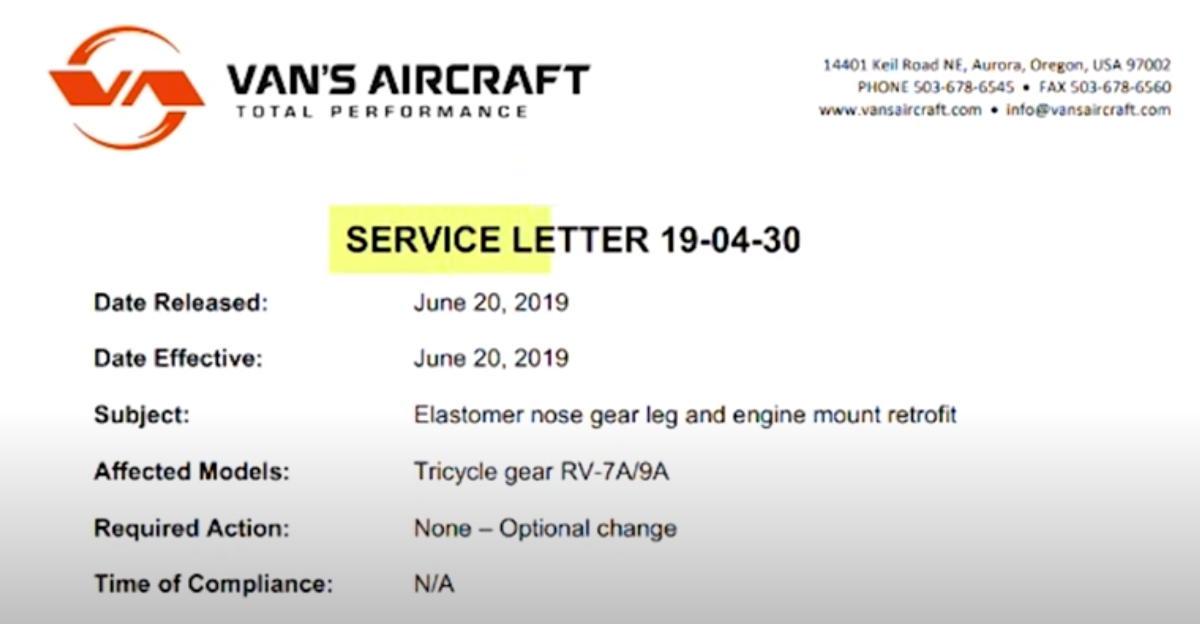
Yeah, anyway, as ATSB says in the YT Description, one of the cases they'd dealt with locally was a 6A: "In January a Van’s RV-9A encountered a tailwind during landing on a private grass airstrip on French Island, Victoria, resulting in a hard landing. The aircraft bounced, and its nose gear then collapsed. The aircraft subsequently nosed over, and came to a rest inverted, resulting in serious injuries to both occupants, and substantial damage to the aircraft. The accident was similar to a few others, including one investigated by the ATSB in 2017. In that accident, the nose gear of a Van’s RV-6A collapsed after the aircraft bounced during a heavy landing on a dirt airstrip in north Queensland. In light of these accidents, the ATSB is urging owners and operators of Van’s RV-6A, RV-7A and RV-9A aircraft to consider Van’s Aircraft Service Letter 19-04-30."
-
Yeah, actually the Service Letter shown in the video mentions only the RV 7A and 9A (the commentary, though, for some reason, mentions "6A") Anyway, I think it's good to see ATSB getting on the front foot with well made safety videos for the home-built crowd. Maybe it will even extend to RAAus-only types.

-
Hey OME, Tooraweenah and Butler get a gig in this one. (I wonder if Aussie airline pilots still mutter "Stone the flamin' crows!" when delayed at the holding point? LOL )
-
Talking about when SYLLABUS meets HUMAN FACTORS: https://www.youtube.com/watch?v=Vv0NNjQOCkI
-
Yes, we can all agree on the Human Factors effect. But when it comes to what coulda, shoulda, mighta been done, absent the startle, I'm still with 'Fred Flintstone' (in the YT Comments): "Without the rudder to counteract the immediate left yaw from applying full power I am guessing this happened very fast. He did not know he lost the rudder but taking out the power and letting the plane go straight would have probably kept him on the airport but maybe not the runway." But that's all conjecture upon conjecture - all apart from the weld failure, that is.
-
Yes, maybe he was going around because he felt his approach was a bit hot. But then his rudder failed, just when he needed it most. If it hadn't, everything would have been fine and dandy. So for me, this one's firmly in the 'mechanical failure' column, sub-section: hidden metal fatigue. In some ways, though, it's the above-mentioned Challenger fatal that hits closer to home. A reminder that as a homebuilt owner/operator it's down to me to keep on top of the issue - hidden or not. (Mechanically challenged or not ;- )
-
Yes, a fascinating read. And here's a video about it: