Garfly
-
Posts
3,057 -
Joined
-
Last visited
-
Days Won
67
Content Type
Profiles
Forums
Gallery
Downloads
Blogs
Events
Store
Aircraft
Resources
Tutorials
Articles
Classifieds
Movies
Books
Community Map
Quizzes
Videos Directory
Everything posted by Garfly
-
Mid-air collision at Caboolture - 28/07/2023
Garfly replied to onetrack's topic in Aircraft Incidents and Accidents
According to this report the Pawnee was going around as the Jabiru was taking off on the crossing runway. One plane in fatal aerial collision north of Brisbane had just aborted a landing attempt, ATSB reveals - ABC News WWW.ABC.NET.AU One pilot survived the mid-air collision near Caboolture Airfield, which killed David and Jan Maddern on Friday morning. -
SubSonex jet • Moruya based • ABC News story
Garfly replied to Garfly's topic in AUS/NZ General Discussion
-
SubSonex jet • Moruya based • ABC News story
Garfly replied to Garfly's topic in AUS/NZ General Discussion
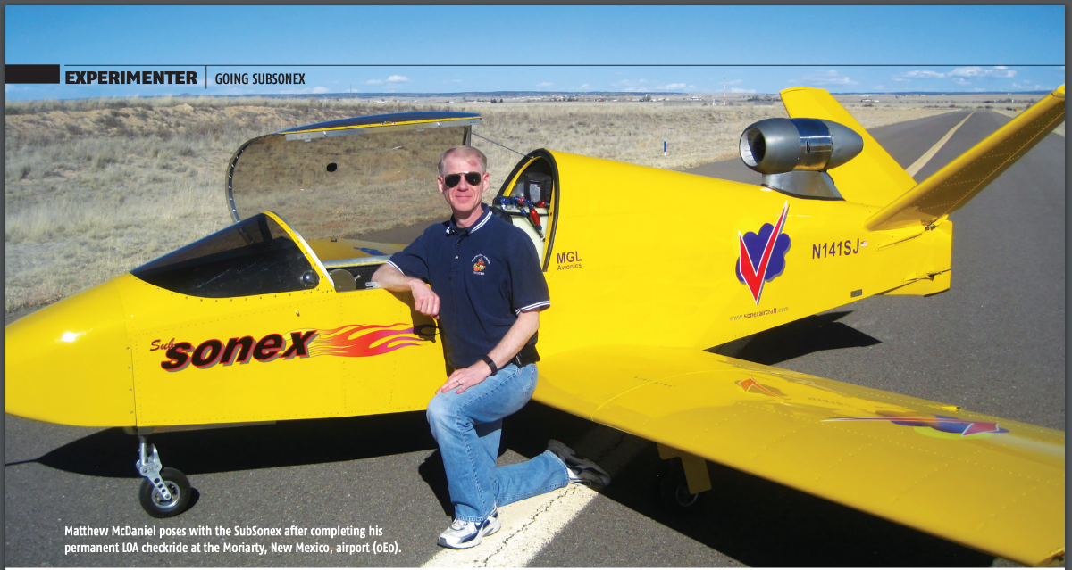
Yep. It's a homebuilt. Surely not pressurised. O2 units available if needed. As mentioned above, it cruises at around 200 Kt. Its engine weighs 20 kilos; smaller than an airliner's APU. Some interesting facts, for anyone interested, in this "Experimenter" article (from some years back, about a prototype of the single seater). https://www.sonexaircraft.com/wp-content/uploads/2018/01/EAASA_SubSonex_Sept_2016.pdf EXCERPTS: "BOB CARLTON COMES SCREAMING down the air show line at nearly 300 mph. The high pitch of the tiny PBS TJ100 jet engine, combined with the vivid canary yellow paint scheme, make the entrance of the JSX-2 SubSonex very hard to ignore ... The JSX-2 could easily be the everyman’s jet, and I was lucky enough to learn why in the most fun way possible—through firsthand experience studying and flying it. SPIRITED PERFORMANCE The density altitude is a whopping 7,000 feet at the runway. While the takeoff roll of the SubSonex is correspondingly long, that is immediately forgotten as the tiny landing gear break free from the runway surface. Even at this altitude, the JSX-2’s performance is so far removed from most aircraft in this weight class that I can’t help but smile. I quickly get back to business and retract the gear as the airspeed rapidly accelerates toward the maximum gear speed of 125 mph. The gear stows within seconds, and 500 feet AGL passes as I reduce the thrust to climb power (98 percent) and arm the engine’s automatic protection computer (more on that later). Climbing at 150 to 160 indicated, I reach maneuvering altitude after only three climbing legs around the airport’s perimeter. The altimeter now reads 9,500 feet MSL (density altitude of around 10,500 feet), but I’m only 3,000 or so feet above New Mexico’s high desert terrain. As I level off, I wonder to myself what the SubSonex’s performance must be like when operating out of Sonex’s home airport of Oshkosh, Wisconsin, in the dead of winter. I’m sure what I just experienced would seem positively anemic in comparison. MICROSTEPS TO MICROJETS Tiny jets have been around for decades. In fact, a fascinating array of them have popped up at AirVenture over the years. However, until recently, flying examples have been essentially limited to novelty air show acts and one-off aircraft originally designed with piston powerplants. The jet engines they used were mostly converted auxiliary power units (APUs) or upscaled RC model aircraft engines. While the former suffered from poor power-to-weight ratios and high fuel consumption, the latter lacked reliability and operational convenience. Additionally, with airframes initially designed without consideration of turbine power, the systems, aerodynamics, and performance limitations can easily negate any advantages that a jet engine (of any variety) might offer. Thus, the microjet that offered any real level of practicality remained elusive. Then, in 2008, a Czech company with decades of experience building military-grade APUs introduced something different, something game-changing. The PBS TJ100 turbojet engine was a modern, clean-sheet design with exceptional thrust-to-weight ratio and fuel economy. Unlike earlier microjet engines, it incorporated computerized digital control, an integrated starter/ generator, recirculating lubrication, and spark ignition. All of which contributed to ease of operation, along with reliable and predictable performance. People noticed. Soon, the TJ100 became very desirable for both small manned aircraft and drone applications. Previously built microjets that struggled with engine reliability for years quietly began to convert to PBS engines. While other applications that had been waiting for just such an engine began to move beyond imaginations and into reality Sonex Aircraft founder and legendary sport plane designer John Monnett set about designing a completely new Sonex. His design would revolve around PBS turbojet power and be optimized to take full advantage of it."
-
SubSonex jet • Moruya based • ABC News story
Garfly replied to Garfly's topic in AUS/NZ General Discussion
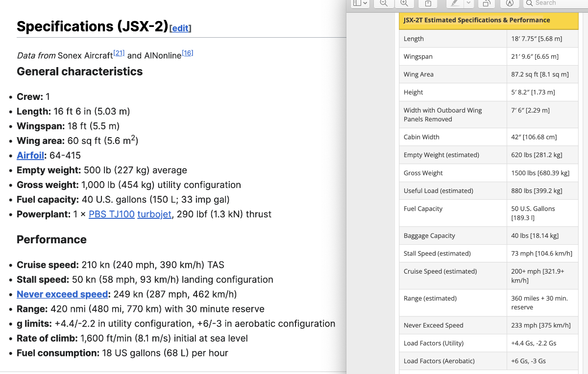
The engine is the same apparently. The wing area is about 47% larger. Lots of info here: SubSonex JSX-2T Update: Successful AirVenture Debut and a Design Tweak – Reserve Your Two-Place Jet Kit Today! – Sonex Aircraft WWW.SONEXAIRCRAFT.COM The long-anticipated Two-Seat SubSonex JSX-2T was unveiled at a record-breaking EAA AirVenture Oshkosh 2022, providing the first opportunity for the public to see the new... I put the specs alongside each other here to compare. [Click the 'thumbnail' to see it properly.]
-
SubSonex jet • Moruya based • ABC News story
Garfly replied to Garfly's topic in AUS/NZ General Discussion
Absolutely, it's a poor man's Vision Jet. ;- ) -
Circuit Issues at uncontrolled aerodromes
Garfly replied to kgwilson's topic in Aircraft General Discussion
Sorry. -
Circuit Issues at uncontrolled aerodromes
Garfly replied to kgwilson's topic in Aircraft General Discussion
I didn't get the impression that BrendAn was unfamiliar with the specs of the aircraft he's already bought. Maybe I missed something. -
Circuit Issues at uncontrolled aerodromes
Garfly replied to kgwilson's topic in Aircraft General Discussion
" "Erratic Manor" would be a good name for where the Munster's live." Ha, ha ... thanks. That is funny. "A joke that takes a while to GET is the best.. Nev" ... and by that measure VERY funny. ;- ) (BTW, outside parts of the lawn bowls and sports flying communities, it'll take a LOT longer still for that joke to land. ) -
SubSonex jet • Moruya based • ABC News story
Garfly replied to Garfly's topic in AUS/NZ General Discussion
I think this chap flies his jet for the sheer fun of it. Zipping up and down the NSW south coast at low level at those speeds would be great. You'd score heaps more beaches per minute than we of the rag and tube. And if personality/character is what you're after that little jet has it in spades. And we know what the endurance is. It's about 2 hours (@sea level?). About perfect for any retiree's bladder. -
Circuit Issues at uncontrolled aerodromes
Garfly replied to kgwilson's topic in Aircraft General Discussion
But the full context is readily available, Nev ... usually just a couple of posts north. Sure, any quoter should avoid twisting the OP's intention, but, at the same time, it would lead to total incoherence if you included all original 'context' when what you're referencing is but one small part of it. I agree with you though, on the numbering of posts. But I've often wished you'd make friends with the 'Quote' button. By the way, what did you mean by that Munster's question? Anyway, Google being Google, and OME being OME, we did end up with the correct answer. LOL https://www.youtube.com/watch?v=HS3WPRFZ6Es -
SubSonex jet • Moruya based • ABC News story
Garfly replied to Garfly's topic in AUS/NZ General Discussion
Yes, two seats would be nice and with the JSX-2T (T for two) that will soon be available (for a cool quarter mil plus, AUD). And as for range (of the current model) 2 hours seems a comfortable leg length and if you can cover over 400NM in that time I'd call it a pretty nice cross-country get-about. And, Andre, our jet-set dentist reckons anyone who can build a letter box can build a Sonex jet. (Which, unfortunately, rules me out, right there ;- ) SubSonex JSX-2T Update: Successful AirVenture Debut and a Design Tweak – Reserve Your Two-Place Jet Kit Today! – Sonex Aircraft WWW.SONEXAIRCRAFT.COM The long-anticipated Two-Seat SubSonex JSX-2T was unveiled at a record-breaking EAA AirVenture Oshkosh 2022, providing the first opportunity for the public to see the new jet prototype. JSX-… -
SubSonex jet • Moruya based • ABC News story
Garfly replied to Garfly's topic in AUS/NZ General Discussion
He would have been talking about his RV10 in that story (he'd asked his wife to come along). I'd say that'd be doable, one long day from Moruya to Alice with one refuelling stop. And then, the next day Alice to Broome in one hit. -
SubSonex jet • Moruya based • ABC News story
Garfly replied to Garfly's topic in AUS/NZ General Discussion
These are the specs of the SubSonex from Wikipedia (I think this is the model in the story). Alice to Broome in one hit looks quite possible in the RV10 but you'd probably want a shorter book in the JSX-2. Maybe 2 books since you'd need to stop half way and find fuel. But what a blast! Specifications (JSX-2)[edit] Data from Sonex Aircraft[21] and AINonline[16] General characteristics Crew: 1 Length: 16 ft 6 in (5.03 m) Wingspan: 18 ft (5.5 m) Wing area: 60 sq ft (5.6 m2) Airfoil: 64-415 Empty weight: 500 lb (227 kg) average Gross weight: 1,000 lb (454 kg) utility configuration Fuel capacity: 40 U.S. gallons (150 L; 33 imp gal) Powerplant: 1 × PBS TJ100 turbojet, 290 lbf (1.3 kN) thrust Performance Cruise speed: 210 kn (240 mph, 390 km/h) TAS Stall speed: 50 kn (58 mph, 93 km/h) landing configuration Never exceed speed: 249 kn (287 mph, 462 km/h) Range: 420 nmi (480 mi, 770 km) with 30 minute reserve g limits: +4.4/-2.2 in utility configuration, +6/-3 in aerobatic configuration Rate of climb: 1,600 ft/min (8.1 m/s) initial at sea level Fuel consumption: 18 US gallons (68 L) per hour Avionics MGL Avionics Flight II instrument and the MGL V10 Com transceiver -
SubSonex jet • Moruya based • ABC News story
Garfly replied to Garfly's topic in AUS/NZ General Discussion
I'm impressed by his relaxed attitude to long-haul (RV10?) flight planning (as he tells it to our reporter, anyway ;- ) "Sometimes I would say to my wife 'I'm going to go put my feet in the Indian Ocean this weekend. If you want to come along, you're welcome.'" "We would fly from here to Alice Springs and spend the night there. The next day we'd be in Broome riding a camel along the beach. "I would literally just dial in the unique airport code, climb to altitude, hit autopilot, and read a book. It's that simple." -
Retired dentist's bird's-eye view of Australia from his homemade jet aircraft - ABC News WWW.ABC.NET.AU It started with model aeroplanes as a teenager. Then he piloted gliders. Now, retired dentist Andre Viljoen has built his own jet aircraft to see Australia's best sights.
-
Circuit Issues at uncontrolled aerodromes
Garfly replied to kgwilson's topic in Aircraft General Discussion
There was also this ATSB report (several decades old now) that brought a lot of vision-science to bear on the issue. see_and_avoid_report_print.pdf -
Circuit Issues at uncontrolled aerodromes
Garfly replied to kgwilson's topic in Aircraft General Discussion
"Just imagine the Possible effect that might have on confusing other circuit traffic. and especially someone going around who got too close to preceding traffic on final.. Nev" Yes, well the reason this thread got started is that we have several of our own having recent near misses in the circuit when everyone involved thought they were doing things by the book. So there's plenty of room for confusion anyway as it stands. -
Circuit Issues at uncontrolled aerodromes
Garfly replied to kgwilson's topic in Aircraft General Discussion
And I see it's sometimes done on the 'dead side' waiting for a gap to open up in the flow. -
Circuit Issues at uncontrolled aerodromes
Garfly replied to kgwilson's topic in Aircraft General Discussion
Likewise, the training area "clearing turn" has always struck me as more of a Hail Mary than an effective "clearing" of the area. At best, it consists of maybe a half-minute look-see over that way then the same over the other side before launching into many minutes of often heads-down concentration on a given set of manoeuvres; instructor and student, both, happy in the knowledge that the sky is (by rite) theirs. And yet every mid-air threat I've ever witnessed has appeared from nowhere and flashed past in seconds countable on one hand. And that does seem to be the experience of most near-miss 'survivors'; there are dozens of videos on the Tube where you actually get to see frame by frame how difficult it is to see collision course traffic even fifty metres out. That's not to say that a 'clearing turn' might not, one day, save your bacon. It conceivably could. (Anyway, not 'doing the honours' on a test flight will surely get you excommunicated.) But, to convince yourself that you've 'cleared the area' just by going through the motions is irresponsible. Lately, in online aviation videos, you do see instructors backing up 'clearing' turns with EFB traffic displays which actually can be relied on to detect nearby threats. But, that's in the US where ADSB is now close to universal. Typical instruction in the customary method: https://www.youtube.com/watch?v=cZJXQpF5bcg -
Circuit Issues at uncontrolled aerodromes
Garfly replied to kgwilson's topic in Aircraft General Discussion
Yeah, that'd be old Capt. Straw-man and his mates; they say a lot of crazy stuff. -
Vale Jim Tweto • Alaskan bush pilot.
Garfly replied to Garfly's topic in Aircraft Incidents and Accidents
Which is comforting. -
Vale Jim Tweto • Alaskan bush pilot.
Garfly replied to Garfly's topic in Aircraft Incidents and Accidents
-
Avid flyer mark iv
Garfly replied to Phillip King's topic in Aircraft Building and Design Discussion
BTW, for any Avid Flyer fans who haven't caught it yet, this is a nice (24') video on it by Jonas Marcinko -
I agree. The problem with AvTraffic's internet based "ADSB" targets in OzRwys is that they show up in the same dark blue that's used for direct ADSB traffic such as supplied by the SkyEcho2. OzRwys traffic (its own participating customers, via internet) is, of course, distinguished by showing as light blue. A couple of years back I had an email exchange with OzRwys support suggesting that direct ADSB targets might be better displayed as a different colour (as opposed to just a darker shade). I was told that they felt the distinction was clear enough and that since "traffic is traffic" it's better, for a consistent iconography, to keep the two types the same basic hue. But as you suggest, Glen, traffic ain't traffic when lag is involved. So I reckon it's time to move to a different colour for true ADSB (real time) traffic.
-
It might sow confusion if we throw around term "traffic display" without being clear that we're talking about cellular network based traffic systems and not about proper ADSB-IN displays. Sure, any internet lags become clear on your EFB screen if you're running proper ADSB-IN at the same time. The position delay seems, in my experience, to vary from zero to several seconds. But just to be clear, there is no latency issue with true ADSB-IN traffic displays (like SkyEcho2 or better). And usually, when we're discussing the use of traffic displays in the circuit - for or agin - we're talking proper ADSB-IN That being said, Area-51's story, a few posts up, shows that even laggy cell based traffic (like his AvTraffic/OzRwys integration) can sometimes work better than any amount of "managing separation visually" : "After one more recent near miss, have upgraded the situational awareness by taking out a paid subscription with AvTraffic ... it paid dividends. The first flight afterward saw almost the exact same scenario with the very same other aircraft, however this time was able to see the situation unfolding well in advance, so simply turned away." OzRwys is clear about the limitations of its cell-based display of traffic information. As they put it "OzRunways traffic is great but it's not the whole picture" before going on to urge customers to invest in a proper ADSB-IN solution. But short of one of those, an AvTraffic/OzRwys (cell based) set-up does have a few plusses of its own, combining OzRwys targets with all other traffic supplied by the 'ADSB-exchange' (most ADSB-OUT equipped aircraft - depending on local coverage) and presenting it all on the familiar (already in use) OzRwys main map page - without need of other devices. Plus AvTraffic has aural traffic alerts. And while those alerts are probably very useful enroute, I can't see how they'd help much in the circuit; wouldn't Bitchin' Betty be having constant conniptions even in a mildly crowded circuit area? I suppose time stamps could overcome lag issues in internet traffic displays (as long as pilots didn't have to do any maths in their heads, when only a glance may be spared) but wouldn't it just be putting lipstick on a pig? ADSB is here - it's an amazing aircraft-to-aircraft tech which just works, is user friendly and is heaps cheaper than it used to be. The problem remains that it's far from universal in VFR land. Too bad the proposal before government years ago for supplying devices free for all VFR aircraft wasn't taken up.