Garfly
-
Posts
3,048 -
Joined
-
Last visited
-
Days Won
67
Content Type
Profiles
Forums
Gallery
Downloads
Blogs
Events
Store
Aircraft
Resources
Tutorials
Articles
Classifieds
Movies
Books
Community Map
Quizzes
Videos Directory
Everything posted by Garfly
-
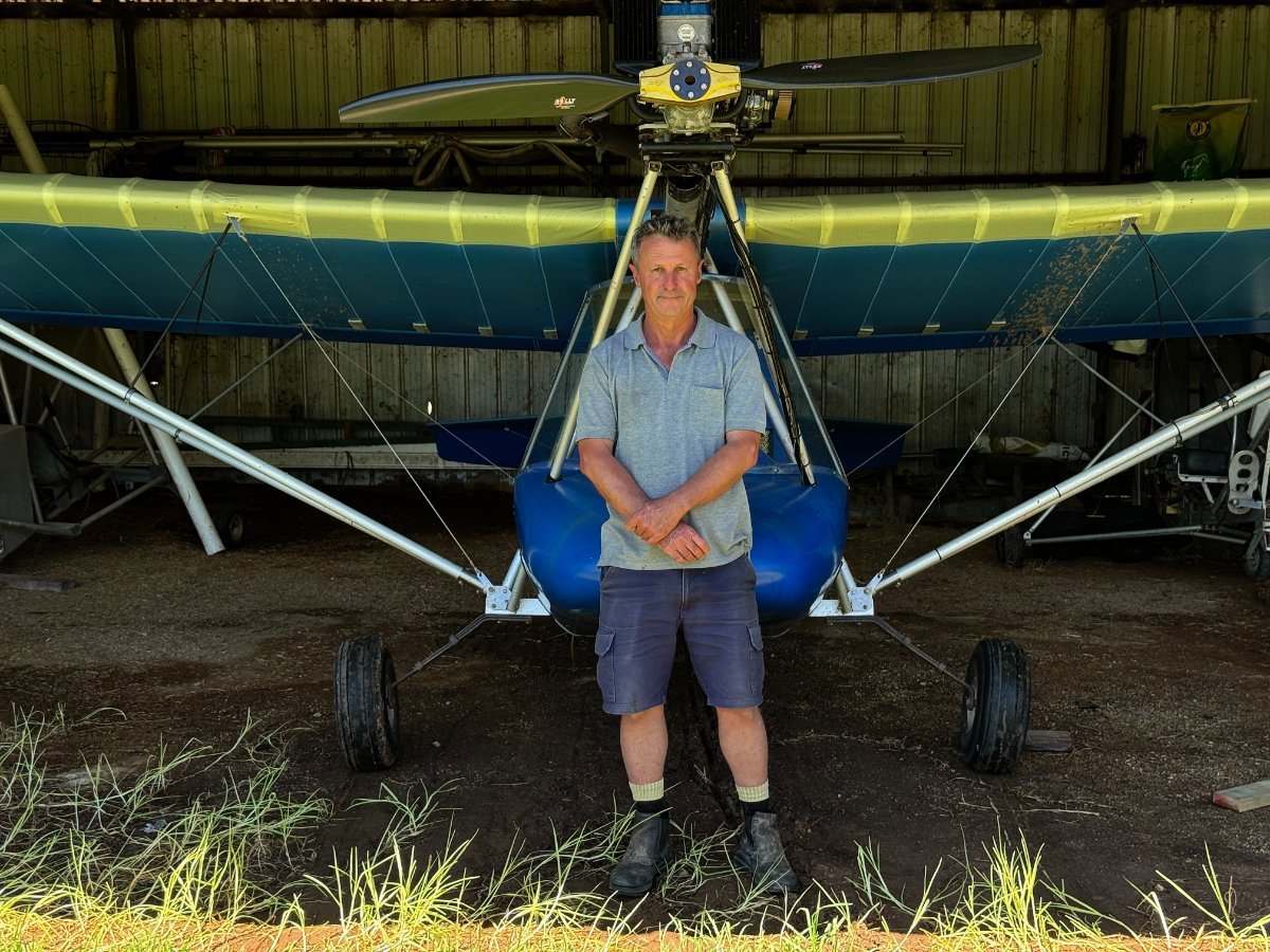
Ha, ha ... it's Thruster we have to feel for. I only took the shots of his fields that'd sprung a leak.
-
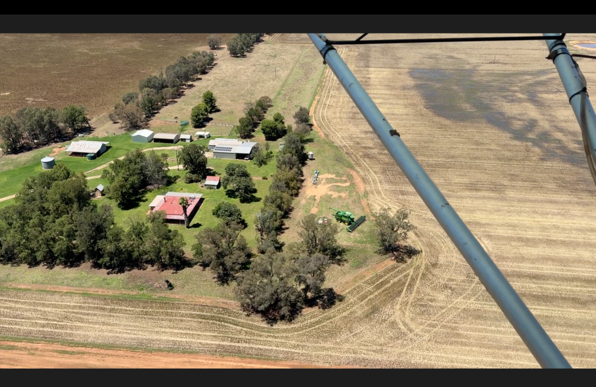
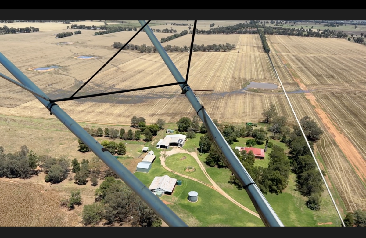
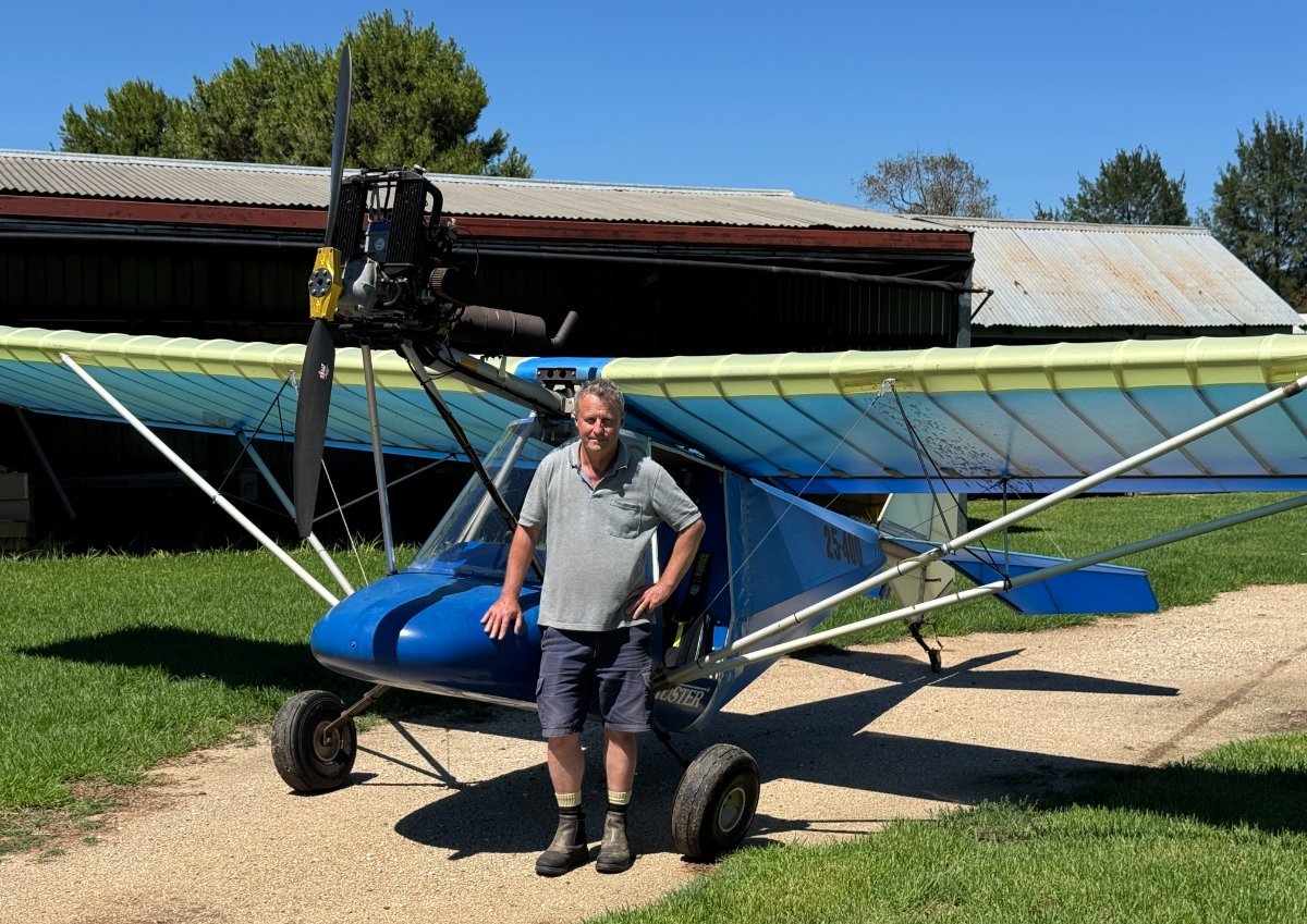
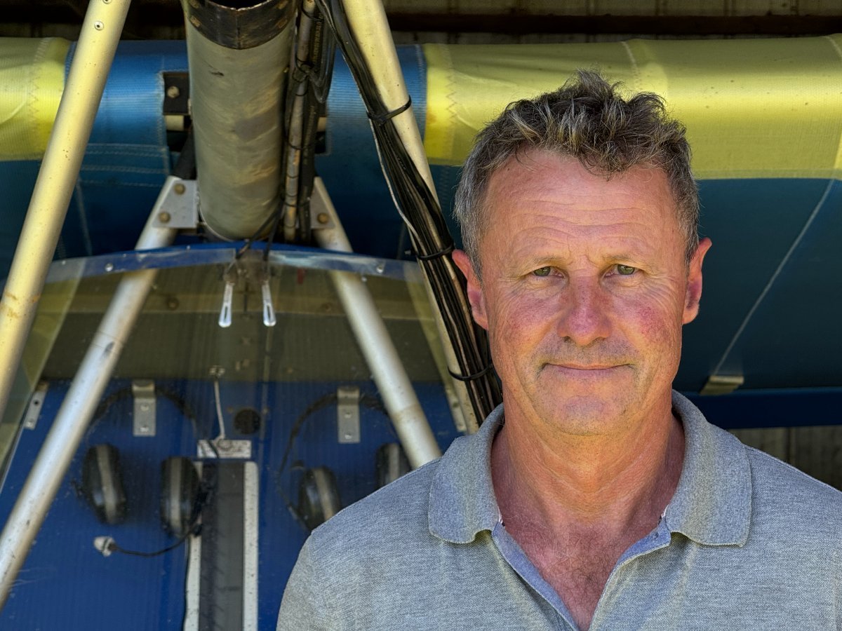
I was lucky enough to fly with the Thruster in his Trusty Thruster a week back, and was able to see for myself the rain damage that had just occurred half way through harvesting. So yes, he was telling me that about half of his crop will be "shot and sprung". Meaning (I now know) that the grain, having germinated in the head, is only good for animal feed. But being born to the land (as well as the air! ;- ) Mr. Thruster was pretty philosophical about his losses. The man, the machine, the soggy fields: [Click for Full Rez] Here is the homestead, looking South ... the green header stopped in its tracks, mid-head! Looking West and showing some of the uncut fields in the upper left Overhead some of the uncut "shot and sprung" crop looking back East.

-
 But the love of flying-for-fun makes Bristell and Bantam owners alike, a band-of-brothers and sisters. ;- )
 -
A FLYING mag article revives the topic of small wakes with big effect. https:https://www.flyingmag.com/i-l-a-f-f-t/the-wake-invisible-gremlin-grabs-your-attention///www.flyingmag.com/i-l-a-f-f-t/the-wake-invisible-gremlin-grabs-your-attention/ hthttps://www.flyingmag.com/i-l-a-f-f-t/the-wake-invisible-gremlin-grabs-your-attention/tps://www.flyingmag.com/i-l-a-f-f-t/the-wake-invisible-gremlin-grabs-your-attention/
-
Here's the short version, then. Which I, for one, wouldn't have deemed credible had the passionate guy in the long version not done research and produced receipts. (You're welcome ;- )
-
Yes, apparently. Improving sustainability by enhanced engine component lifetime through friction modifier additives in fuels - ScienceDirect WWW.SCIENCEDIRECT.COM Engine test rig runs with a standard and a friction modifier containing premium fuel using an artificially altered close to end-of-life oil were... "All 3 independent methods for wear measurement confirmed that the premium fuel containing friction modifier results in an overall superior wear protection compared to standard fuel. Mass spectrometry of oil aliquots from the engine test rig runs showed an accumulation of friction modifier in the end-of-life engine oil, which explains the better tribological characteristics observed in this case. Accordingly, application of friction modifier in fuels can lead to increased oil change intervals since the wear protection is acceptable even in case of an end-of-life oil condition and potentially improved engine component lifetime. Both factors offer economic and environmental benefits."
-
This guy makes the point that there can be more to premium fuels than octane ratings. He reckons that premium additives like friction-modifiers can make a big difference to engine wear. (with Octane ratings measured differently in the US, their label numbers don't line up with ours)
-
Dingo – Future Vehicles s.r.o. WWW.FUTUREVEHICLES.EU The original features in this new video about 5 vintage ultralights: 00:24 Ultraflight Lazair 03:19 Mitchell U-2 05:58 Wood Skypup 07:56 Hovey Whing Ding 10:10 Diehl XTC
-
These four films cover the trip as far as Darwin (a series covering their flying within Australia is due later).
-
-
A new film about the AW 15 Atalanta from 'Rex's Hangar':
-
-
- 2
-

-
SkyEcho 2 - ADSB light doesn't come on...
Garfly replied to Philster2001's topic in Instruments, Radios and Electronics
Another issue to keep in mind (which others have mentioned here) is that it's fairly easy to inadvertently turn the unit on as you stuff it into a flight bag or whatever. It doesn't take much pressure to operate that barely recessed button. I've taken to gaffer-taping an old credit card across the whole face of the SE2 to guard against that happening. -
Another great trip vid • RV12 takes off for a big lap
Garfly replied to Garfly's topic in Trips/Events/Seats
Actually, not such a big lap this time (I took the title too literally at first ;- ) But still ... a witty, well made movie of a little two-day lap around the Mangalore - Echuca - Griffith track. You really get the feeling that you know Oleg and Dina personally by trip's end. In this way, the vids are a lot like the "Flying Around" series by Scott Hendry and his wife Chris. https://www.youtube.com/user/thecscotthendry -
-
-
SkyEcho 2 - ADSB light doesn't come on...
Garfly replied to Philster2001's topic in Instruments, Radios and Electronics
Whereas ADSB-OUT is mandatory for all IFR a/c (so we should see all of them, with our SE2/EFBs) there's no requirement for them to be equipped with ADSB-IN and CDTI (Cockpit Display of Traffic Information). So there's no guarantee they will see our SE2s. (Many can and do though, it's hard to know; same with ATC - the situation is complicated and fluid.) IFR ops often have TCAS but the SE2 (and other EC devices) are not visible to TCAS - which only sees and reacts to proper transponders. But I think that state of affairs, too, is evolving as we march towards mandatory universal 1090 IN and OUT. P.S: These are good reads (but also might need updating) advisory-circular-91-23-ads-b-enhancing-situational-awareness 2.pdfVFR and visible _ Flight Safety Australia.pdf -
SkyEcho 2 - ADSB light doesn't come on...
Garfly replied to Philster2001's topic in Instruments, Radios and Electronics
Yeah, the SE2 works on Pressure Altitude so, in effect, it's always sending Flight Level, not AMSL. ACAS systems all use PA since they're only really interested in own-ship's vertical relation to nearby targets; high or low, trending up or down. -
Max Holste MH.1521 Broussard - Wikipedia EN.WIKIPEDIA.ORG
-
- 3
-
-
SkyEcho 2 - ADSB light doesn't come on...
Garfly replied to Philster2001's topic in Instruments, Radios and Electronics
And maybe find a white hankie to shield it from the sun's heat. Your buyer's remorse is sure to lessen the first time it saves your bacon. (Or even just saves some needless worry once in a while ;- ) -
Sure, if an airline pilot hasn't done any GA flying in 30 years then they'd probably want and need some transition training before going over to RA. But that's a process they've been used to their whole career. These days, though, a pilot leaving GA for RA might be going, say, from a draggy old Maule to a slippery Pipistrel. (Or a thirty-thousand hour ag pilot going over to ... well, anything). Not exactly what the regs had in mind. So, yeah, while transition training is always advisable, it no longer makes sense to mandate a fixed number of hours for candidates who don't need it. Competency based testing is now fairly well accepted in aviation. P.S: An interesting FAA take on transition training: https://www.youtube.com/watch?v=TpxJIr4dsF8 "The lack of transition training has been cited as a causal factor in many GA accidents. Accidents frequently result from pilots being unprepared for challenges presented by the new, or different, aircraft they are flying. Even when pilots are legally certificated to operate aircraft within a specific category and class, significant differences can exist among different types of aircraft within that category and class — thus necessitating the need for effective transition training."
-
What?! RAIM is a concept used in IFR ops. Anyway, even if the whole GPS system did drop out (ever happened here?) you'd still have your (approved) iPad charts to read - easier to handle (and enlarge for detail) than finding and unfolding paper ones in a hurry. You'd use them with your compass and watch and paper flight plan you have as back-up. If your iPad dies then you fall back on your phone and/or spare GPS and the paper charts you do have in your flight bag. Well, at least you have a fix on where you were a minute ago - before the sky fell in - as it's so wont to do. I don't suppose this CASA guy would be asking if you'd considered taking up the feds offer of a nice new half-subsidised SkyEcho2. Of course not! They don't believe in all that 'distracting' tech stuff. Never have. What's wrong with the Old Eyeball v1.0!? Worked for him (if not, sadly, for everyone).
-
And, in some cases, much less, I guess.
-
Yeah, there's a fair bit in OzRwys that wasn't in my old Garmin12 from the early 90's. It had one of those much maligned GoTo buttons, though. The GA establishment was not impressed; certain that the sky would fall in if ordinary aviators ever got access to such thingies. Stories abounded of hapless GoTo navigators blundering into airspace and mountains, blindly following their diabolical handheld GPS thingies. Few of those stories were true but the suspicion of GA GPS (despite the obvious benefits) hung around for a good long while. Now it's ADS-B. Go figure.
-
I'm a bit surprised that you would - or even could - be required to undergo such a demanding, costly and wrongheaded BFR. In my opinion, their insistence on your having to use way-out-of-date, and demonstrably less reliable, less safe nav methods seems weird. Some kind of confirmation rite of yore. That's no way to test for competence and safe airmanship in today's complex aviation environment. (Even if there's still a case to be made for ab initio training in the old ways.) I'd be interested to know which arm of CASA did the deciding on this - and on what basis. Is this normal? In any case, AFAIK, you'd not be required to do any nav test as part of your conversion to RAAus. So I guess you'd be trading in your Mooney, then, for something more on the ultra end of things. ;- )