Garfly
-
Posts
3,057 -
Joined
-
Last visited
-
Days Won
67
Content Type
Profiles
Forums
Gallery
Downloads
Blogs
Events
Store
Aircraft
Resources
Tutorials
Articles
Classifieds
Movies
Books
Community Map
Quizzes
Videos Directory
Everything posted by Garfly
-
Piper Archer down SW Sydney 22/08/2024
Garfly replied to planedriver's topic in Aircraft Incidents and Accidents
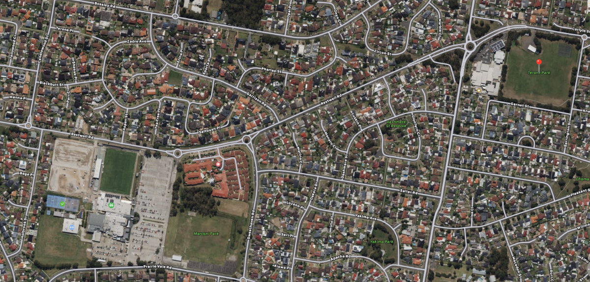
Yes, Terone Park is top-right in this pic, whereas the ARFF WORLD video had zoomed in to the little green patch at the lower left. Interesting that they'd sourced the Mayday call, though.
-
Piper Archer down SW Sydney 22/08/2024
Garfly replied to planedriver's topic in Aircraft Incidents and Accidents
-
Lets Go Aviate has a go at that: https://www.youtube.com/watch?v=X2_orSNXGWk
-
I like Let's Go Aviate's series of video essays. In this one he looks into the history of inline-fours for aeroplanes, finishing up with the recent offerings from Viking, Aeromomentum and Edge.
-
Many Aussie Rangers have the 90L tank installed behind the seat without CG problems. Some with a BRS installed as well. Without the BRS the hammock can still sit on top - albeit with a somewhat smaller capacity. But others, like Blueadventures' Nynja carry the same amount, or more, in specially designed (by Greg Robertson) wing tanks. The 60L tanks were usually seen as inadequate for the distances commonly encountered flying in Oz. Flylight, in the UK, have done their own mods on the GR wing tanks and, I believe, Mr. Dewhurst has them in his own Nynja now.
-
That's exactly the info I was looking for A-51, thanks a lot for that. Sounds like a very productive conversation is already underway. I reckon whatever gets worked out for VFR coastal transit it will be applied to the very similar Coffs Harbour Class D situation - and maybe others. In any case, there seemed to me to be hints in the Airspace Review language regarding changes to the RAAus into controlled airspace arrangements.
-
Hey Hopey, good to hear you're happy with your aircraft. Could you send us some pictures?
-
Yes, something has been needed for ages and working out just what was the job of CASA's Ballina Airspace Review which published its findings in late 2022. It was back in Nov 2020 that a Jabiru and an Airbus A320 managed to miss each other by a mere 600'. https://www.atsb.gov.au/media/news-items/2022/ballina-airspace That incident would have set the cat among the pigeons on the vexed issue of Jet airliners mixing it up with GA/Sports types in Class G. Anyway, it sparked the establishment of the Ballina SFIS (Surveillance Flight Information Service) a kind of poor man's control zone - as an interim measure, at least. But then, in Sep. 2021, and on SFIS's watch, a C208 took-off headlong into the path of a landing Boeing 737. https://www.atsb.gov.au/media/news-items/2023/ballina-separation-incident-highlights-importance-pilots-communicating-directly-other-aircraft-ctaf-where-sfis-place So, in Nov. 23 CASA announced its plan for a proper control zone at Ballina: https://www.casa.gov.au/about-us/news-media-releases-and-speeches/improvements-ballina-airspace-come-effect-2025 So, as it stands, I'm wondering what the general aviation community around this region is thinking about the proposal, now that its details are out. What I find a bit encouraging is that the language of the Airspace Review seems to envisage some kind of regulatory accommodation with non-IFR craft; that they should not be excluded as a matter of course; that they should, by some means, be authorised to operate within it. That's why I'm interested in just what is passing between RAAus and CASA/AA on this issue right now. Can we expect some movement on the 'access to controlled airspace' issue, maybe before this new zone becomes a reality? Also it bears, I think, on how CASA judges its ADSB-in/out for the masses program has fared so far and what other plans it has up its sleeve in that regard. Including, I'd imagine thoughts about mandating ADSB-IN cockpit displays in all IFR aircraft. Anyway, below is the relevant part of the Review, as re-published by ATSB. I emphasise (in red) the bits I think are of special interest to us. Regulatory oversight The Airspace Act 2007 assigned the administration and regulation of Australian administered airspace to the Civil Aviation Safety Authority (CASA). As part of this function, CASA was required to undertake regular reviews of airspace to determine if existing classifications were appropriate, air navigation services and facilities were suitable, there was safe, efficient, and equitable use of airspace, and identify any associated risk factors. On 15 December 2022, CASA publicly released a final Ballina airspace review. The review identified 3 areas of concern: Frequency congestion Heightened risk of separation incidents Situational awareness As a result, the review made 9 recommendations (Table 1). Table 1: Ballina airspace review recommendations No. Recommendation 1 CASA should prepare a Request For Change (RFC) to separate the Lismore and Casino Common Traffic Advisory Frequency (CTAF) from the Ballina CTAF by 16 June 2022. 2 Evans Head Airport should be allocated the common CTAF (126.7 MHz) by 16 June 2022. 3 CASA should direct AA to install an Automatic Dependent Surveillance - Broadcast (ADS-B) ground station in the vicinity of Ballina to improve surveillance as soon as practicable but no later than April 2023. The ground station should, as far as is practical, provide ADS-B surveillance capability to the runway surface. 4 CASA should explore a suitable regulatory framework that can safely authorise sport and recreational aircraft and pilot certificate holders to operate in the controlled airspace associated with Ballina where pilot certificate holders meet CASA specified competency standards and the aircraft are appropriately equipped. 5 CASA’s Stakeholder Engagement Division (SED) should conduct additional safety promotion programs in relation to Ballina operations as soon as practicable. The programs should include, but are not limited to the following key elements: a. reinforce the mandatory radio calls required when operating within the Ballina MBA in the interim, pending the establishment of controlled airspace, and b. later, provide guidance as to how a Sport Aviation Body might develop a suitable scheme and make application to CASA for approval, under the regulatory framework identified in recommendation 4. 6 Uncertified aerodromes and flight training areas around Ballina should be promulgated in aeronautical publications to increase pilot situational awareness. 7 As an interim action pending the completion of Recommendation 8, CASA should make a determination to establish a control area around Ballina Byron Gateway Airport with a base which is as low as possible, and direct AA to provide services within the control area. The services should be provided during all periods of scheduled Air Transport Operations and include an Approach Control Service to aircraft operating under the Instrument Flight Rules (IFR), separation between IFR aircraft, VFR traffic information to all aircraft, and sequencing of all aircraft to and from the runway. CASA and AA should jointly explore opportunities to detect non-cooperative aircraft or vehicles in the immediate vicinity of the runway. The services should be established as soon as practicable but no later than 30 November 2023. 8 CASA should make a determination that Ballina Byron Gateway Airport will become a controlled aerodrome with an associated control zone and control area, and direct Airservices Australia (AA) to provide an Aerodrome Control Service1 to the aerodrome. That service should be established as soon as practicable but no later than 13 June 2024. 9 CASA should prepare and finalise an Airspace Change Proposal (ACP) for a control zone and control area steps in preparation for the implementation of Recommendations 7 and 8. Source: Airspace Review of Ballina – 2022 with minor amendments by the ATSB
-
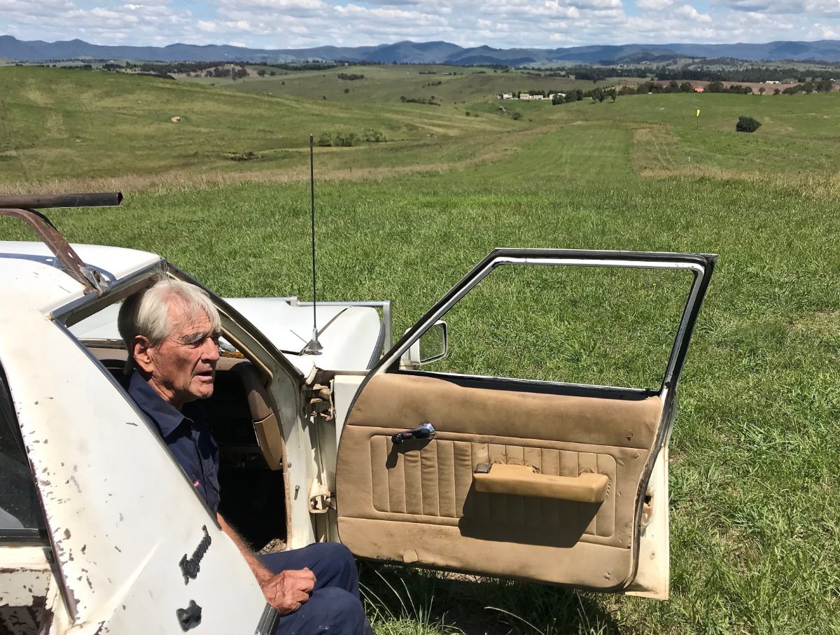
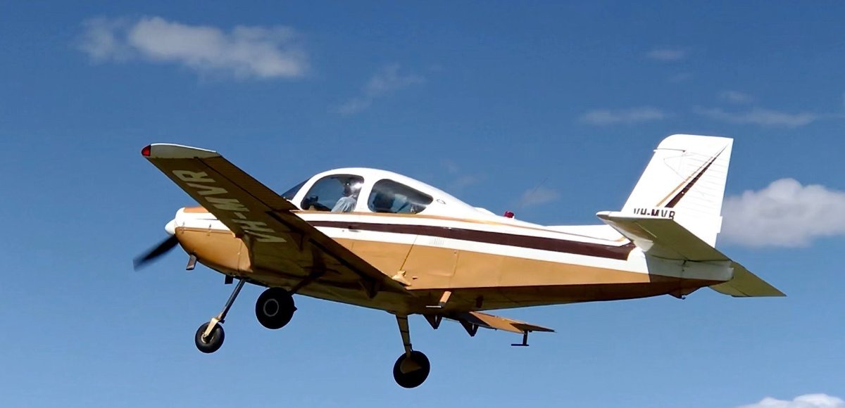
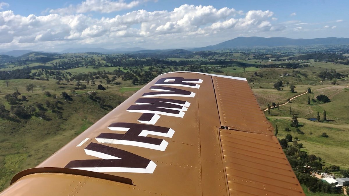
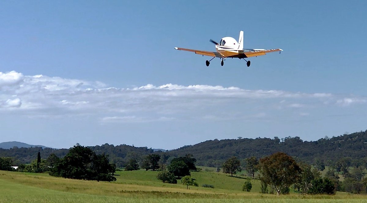
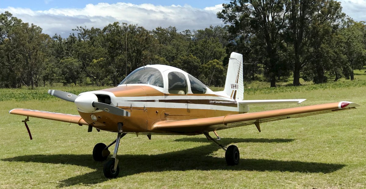
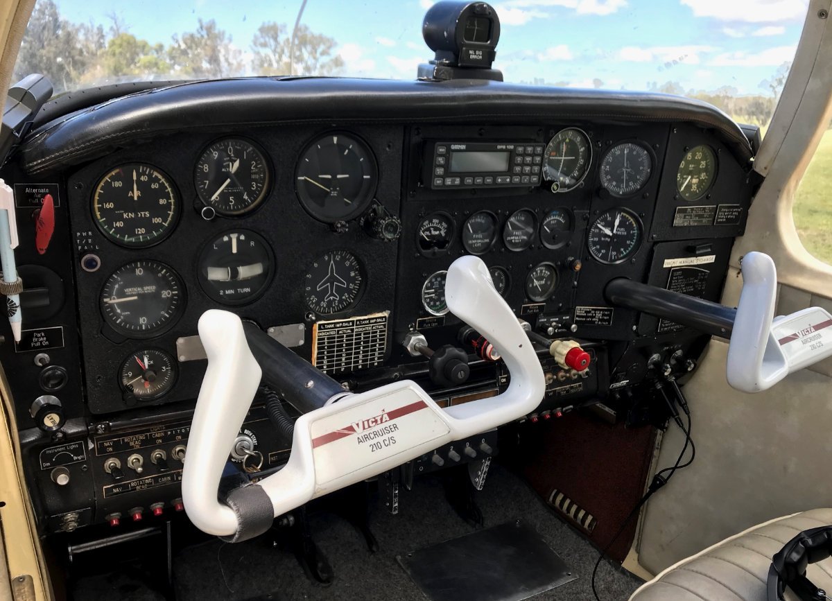
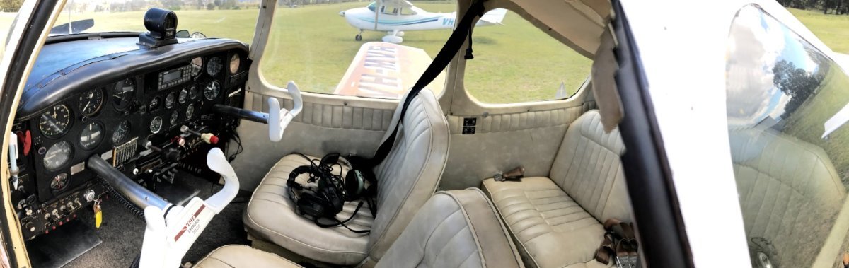
Yeah, I reckon it's a great pity that the government didn't see fit, way back then, to assist our budding light aircraft industry. The New Zealanders took on the design and made a good fist of it with the CT-4. I wonder what happened to the idea of Brumby Aircraft in Cowra picking up the traces of the 4 place Victa. Anyway, the chap who owned MVR in the recent past was larger-than-life Bega-Frogs Hollow character, Des Heffernan. He also kept a Victa Airtourer in his hangar/barn on his property/airfield at Buckajo. (I hear that he's recently sold the AirCruiser.) Des Heffernan — National Road Transport Museum WWW.ROADTRANSPORTHALL.COM Sapphire Stories (@sapphire_stories) • Instagram photos and videos WWW.INSTAGRAM.COM 49 likes, 3 comments - sapphire_stories on February 15, 2024: "Brothers Frank, Des and Vin Heffernan flew together in the 1960s from Merimbula, Frogs Hollow and Buckajo, working, taking people on joy... These snaps are from a few years back. CLICK FOR FULL SIZE:
-
This looks like it will put a big dampener on recreational flying in the area. I wonder what the local aviation mob is thinking about this. And I wonder how RAAus is going with those negotiations regarding controlled airspace entry. Ballina airspace design - introduction of controlled airspace - Civil Aviation Safety Authority - Citizen Space CONSULTATION.CASA.GOV.AU Find and participate in consultations run by the Civil Aviation Safety Authority
-
Came across this well made trip-video uploaded a year ago by Adam Surplice. (AFAIK, it hasn't been posted here before.) For more cross-country inspiration there are lots of great aerial road movies (also ex-Heck) here: https://www.youtube.com/user/TheCscotthendry
- 1 reply
-
- 4
-

-
They also could have included the Aussie contender, the Victa Aircruiser. Only the prototype VH-MVR (still flying and seen here at Frogs Hollow, Bega, a few years back) was ever made. CLICK PICS FOR FULL SIZE Victa Aircruiser - Wikipedia EN.WIKIPEDIA.ORG
-
(Referring to the second of the three videos) Yeah, Skippy I'm not sure how fair and apples-to-apples those weigh-ins were. Clearly the Viking guy is a bit sensitive to the "too heavy" criticism he gets and wanted to put it into context. Anyway, I suppose if he made it work on the Skyranger (with a bit of ballast in the back?) I suppose he has a point. It'd be interesting to know how that Ranger is faring. I notice in this video he claims that the Vikings are no longer the 'alternative' choice for the Zenith in the US but rather the dominant one. https://www.youtube.com/watch?v=aq2iLz_TsB8
-
Me? I run the standard 912ULS. And yes, I'd hesitate to experiment with exotic engines, m'self. But I do admire folks with the savvy and confidence to do so. Which is why I liked the story of the Viking/Zenith750 guy (above) who found himself grounded a long way from home with a cracked cylinder (as it turned out). The way he took us with him on that week long journey from precautionary landing to back in the air was, to me, terrific; both as video-story telling and as in-depth technical information.
-
And, while we're on the subject, a story of a Zenith 750/Viking owner finding it necessary to swap out the engine core at 1150 hours.
-
And in this vid Viking defends itself on the relative weight issue.
-
No need for apologies Red, but neither is the issue giggle-worthy This PPrune thread shows that (even in Old Blighty) various opinions are abroad as to how times ought be recorded. Show of hands - Logging Engine Hours ?? - PPRuNe Forums WWW.PPRUNE.ORG Private Flying - Show of hands - Logging Engine Hours ?? - Evening All.... What is the Correct way of Logging Engine time ? (Can anyone point me to the CAA Rules regarding this ??) For the past 14 years I...
-
And now for something a little different at TIAT
Garfly replied to tillmanr's topic in Aviation Videos
And, heck! I've seen an old Thruster in Cowra do better than this!!! -
Reminiscing! Ultralight Photos And Stories From The Early Days.
Garfly replied to farri's topic in Other Rec Aircraft
Lots of nostalgia available on the Chris Conroy YouTube channel: -
Mangalore incident today (19/2/2020)
Garfly replied to biggles's topic in Aircraft Incidents and Accidents
No argument there. I think we all agree. -
Mangalore incident today (19/2/2020)
Garfly replied to biggles's topic in Aircraft Incidents and Accidents
Yes, for sure, an ATD is totally necessary for one's own log keeping. I just meant that if you're flying with no plan in the system it doesn't mean much to anyone else. In which case, the only estimate that counts (for others) is the one we give inbound at 10 miles. -
Mangalore incident today (19/2/2020)
Garfly replied to biggles's topic in Aircraft Incidents and Accidents
Yeah, it can be quite a while between chocks-away and taking-off, so our intentions might best be held back till later in the piece. That way, any significant others with some interest in our plans, are more likely to be inside the zone and listening in. In the old days of VFR flight plans and full reporting, an actual time of departure was required by the system to start the clock on the schedule submitted. But in our uncontrolled, NOSAR/NODETAILS world, I guess a (local) departure call just needs current position (or circuit leg) altitude (passing and on-climb) and track (or first waypoint). As far as I can see, declaring an ATD (almost always 'this time' anyway) in a CTAF context is a vestige of other times/other systems. Anyway, I'm not saying departure calls are even necessary; it depends. Which must be why law makers limit themselves (uncharacteristically) to 'recommendations' when it comes to comms at uncontrolled fields. -
Mangalore incident today (19/2/2020)
Garfly replied to biggles's topic in Aircraft Incidents and Accidents
While TCAS may be better, the cost of those systems makes it impractical for small aircraft - even for commercial IFR operators, let alone recreational types. A few years back the charter industry was squealing about being forced to put in ADS-B OUT gear - a far cheaper option than full TCAS. Yet, with the current rebate program even recreational types can get, let's say, 75% of the TCAS safety function for, what?, 5% of the cost. (By carrying approved EC IN/OUT devices.) In their own Mangalore report, the ATSB opined that had either or both aircraft carried even such basic ADSB IN/OUT gear then it might all have been avoided. Also, the Coroner's Recommendation # 1 has something to say on the issue of "Departure Calls" which have been discussed here recently in other threads. From the CORONIAL INQUIRY INTO THE MANGALORE AIRCRAFT ACCIDENT Recommendation 1: I recommend that CASA develop and disseminate educational material for the aviation industry aimed at reinforcing the importance of accurate departure calls being made by pilots in command of aircraft. It is a matter for CASA to determine the process by which the educational material is disseminated to the aviation industry. Recommendation 2: Airservices, in anticipation of harmonisation of operating requirements for Brisbane ATSC and Melbourne ATSC, provide additional training to ATCs on managing and responding to STCAs within 5 nautical miles of aerodromes with similar aircraft movements to Mangalore. Recommendation 3: 80 Airservices should consider providing additional training to current and prospective Air Traffic Controllers on the use of velocity vectors in Class G airspace. It is a matter for Airservices to determine how this training is developed and facilitated. Recommendation 4: I recommend that the ATSB, AMSA and CASA continue to work together to promote the voluntary update of ADS-B technology in Australian-registered aircraft. It is a matter for the ATSB, AMSA and CASA to determine how to best promote this initiative in the aviation industry. Recommendation 5: I recommend that CASA conduct a cost-benefit study into the feasibility and potential benefits of requiring the installation of ADS-B IN devices in IFR-certified aircraft. Recommendation 6: I recommend that the Minister for the Commonwealth Department of Infrastructure give consideration to expanding the ADS-B rebate program to extend to Australian registered IFR aircraft.