Garfly
-
Posts
3,057 -
Joined
-
Last visited
-
Days Won
67
Content Type
Profiles
Forums
Gallery
Downloads
Blogs
Events
Store
Aircraft
Resources
Tutorials
Articles
Classifieds
Movies
Books
Community Map
Quizzes
Videos Directory
Everything posted by Garfly
-
-
-
 https://www.atsb.gov.au/sites/default/files/2024-11/AO-2023-042 Final.pdf "In-flight upset involving Boeing 737-8FE, VH-YQR 143 km west of Ballina/Byron Gateway Airport, New South Wales on 6 September 2023" ATSB Transport Safety Report Aviation Occurrence Investigation (Short) AO-2023-042 Final – 29 November 2024 EXCERPT: "On the initial application of the rudder trim, both pilots felt the aircraft’s immediate yaw/roll response, but were unable to identify the likely cause. Over the following 5 seconds, while the captain maintained activation of the switch and waited for the door to open, the rudder trim progressively increased to the left, causing the rudder to correspondingly move to the left. The autopilot was initially able to compensate for the increasing left yaw input and induced left roll through application of increasing right wing down roll input. This right wing down input was replicated on the pilots’ control wheel. After 5 seconds of trim input and increasing induced left roll, the autopilot reached its authority limit – that is, the autopilot had reached the maximum roll control input it could apply and maintain. Up to this point, the autopilot had managed to limit the induced roll to a bank angle of less than 5° to the left. However, on reaching the roll authority limit, the increasing rudder trim resulted in the aircraft’s bank angle to the left increasing. As the trim input continued for a further 3 seconds, the aircraft responded with a rapidly increasing rate of roll to the left. The unexpected and increasing bank angle alerted both pilots to the developing aircraft upset. The PF initially responded by attempting to control the increasing left roll through the use of the mode control panel heading selections and the autopilot. As this had no apparent effect, and with the bank angle continuing to increase, the PF applied a large right wing down control input while almost simultaneously disengaged the autopilot and autothrottle. At about the same time the bank angle alert triggered. The PM responded with an ‘upset’ call, and the PF responded by executing the upset recovery procedure. The aircraft was quickly recovered to about straight and level flight. Having recovered the aircraft to an approximate wings level attitude, the PF was required to hold about 35° of right wing down control wheel displacement to maintain that attitude. While this large roll input required to maintain a wings level attitude strongly indicated a yaw-related issue, the crew continued to investigate the cause of the inflight upset unsuccessfully for a further minute. About 70 seconds after the initial misapplication of rudder trim, the PF requested the PM check the rudder trim. Shortly after, the rudder trim was returned to a neutral position. While large right wing down aileron input required to maintain a wings level attitude provided a strong indicator that the upset was linked to a yaw related issue, a combination of the very small displacement of the rudder pedals at the point of maximum trim application, and the PF’s limited experience on the aircraft, probably contributed to some of the delay in identifying the unintended rudder trim."
 -
A handy reminder to pay heed to the switches we flick till they're well and truly flicked.
-
Juan's update: https://www.youtube.com/watch?v=n9mAUks0krI
-
A new dead-stick, failed forced landing analysis from Scott Perdue:
-
E-Props ...who has first hand experience with these
Garfly replied to eightyknots's topic in Engines and Props
-
Some good insights here: https://www.youtube.com/watch?v=LKJklQRyKxo
-
A fair question, although those aren't the only two reasons folks have for saying stuff. Anyway, I'd say my opinion is based on long familiarity with the format of the piece; a well worn (but still effective) template in the misinformation industry. (Not all those brothers-in-law are likely legit. And the oddly inserted theory about this bro's demise 45 years ago, sort of lets the cat out of the bag: "He was killed in a military C-12 plane crash when escaping Iran. I believe his transport was shot down. If so, it was covered up by the Carter Administration to avoid fanning the flames of war, but that is another issue." Another issue!! If so!! ) But meanwhile, back at now; in fact, the identity of the third crew member is, at this time, still being withheld by the family and the US Army. And for good reason: 'Illinois Democrat Sen. Tammy Duckworth, herself a decorated former Black Hawk pilot, told NPR she understood why the family declined to make their loved-one's name public. " We should be respecting the family's wishes at a time when they have suffered an unbelievable loss," Duckworth said. "I think it is a perfectly legitimate request the family would make. And I'm glad that the Army is honoring that request." Duckworth condemned the online speculation about the third member of the crew and especially President Trump's musings that the Army crew was to blame or was affected by diversity, equity and inclusion (DEI) hiring. "Every one of those troops that was in that aircraft earned their place there, and they are the most highly trained military aviators in the world," Duckworth said. "And I am just sick to my stomach that we would have a president who would say such things about the heroic men and women who serve every single day." ' Source: Army withholds name of Black Hawk helicopter crew in D.C. crash, 2 others identified WWW.NPR.ORG At the request of the family, the Army is not going to release the name of the female member of the Black Hawk crew killed in Wednesday's crash. The withholding of the name is a highly unusual move. By the way, this site Unreported Truths seems to be one of the sources of the chain email above A military and civilian aviation veteran explains Wednesday night's crash ALEXBERENSON.SUBSTACK.COM Several pilots wrote in - I thank you all. I found this explanation both admirably complete and largely apolitical, and I think you will too. If you scroll to the bottom of the page you'll see what else exercises them right now: Vaccinated English adults under 60 are dying at twice the rate of unvaccinated people the same age And have been for six months. This chart may seem unbelievable or impossible, but it's correct, based on weekly data from the British government. Nov 21, 2021 • Alex Berenson 2,100 697 URGENT: Covid vaccines will keep you from acquiring full immunity EVEN IF YOU ARE INFECTED AND RECOVER Don’t take it from me, I don’t even get to tweet anymore. Oct 22, 2021 • Alex Berenson
-
All the hallmarks of a professional misinfo job - the kind that tends to "show up" in feeds and forums all over. Typically, a collection of true facts and reasoned opinions (from open sources) lends credibility to the actual punch-line, in this case involving "sincere hope". And then the clincher ... the "I know this because" part (which, weirdly, often involves a brother-in-law in the know).
-
CASA explains the rules (Please explain).
Garfly replied to Garfly's topic in AUS/NZ General Discussion
Okay, here's a link to that: Draft guidance on radiotelephony procedures - Civil Aviation Safety Authority - Citizen Space CONSULTATION.CASA.GOV.AU Find and participate in consultations run by the Civil Aviation Safety Authority Draft Multi-Part AC 64.B-01, AC 91-35, AC 139-14 and AC 172-04 v1 -
CASA explains the rules (Please explain).
Garfly replied to Garfly's topic in AUS/NZ General Discussion
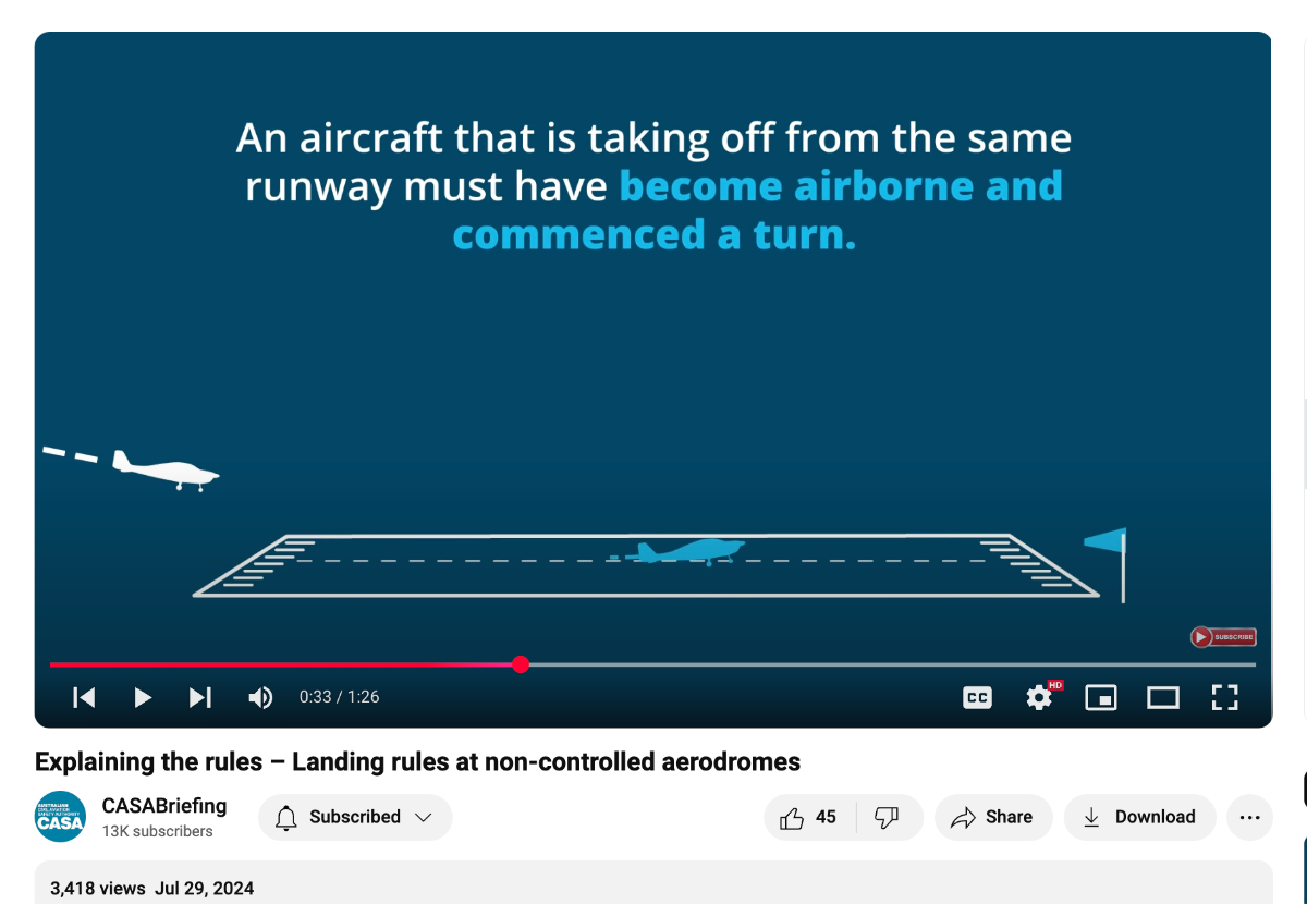
Simples? But there's no suggestion of any either/or scenarios in the video. The commentary names both as "certain criteria" that must be met. (Not either one criterion or another). "You must not continue approach to land beyond the threshold of the runway until you meet certain criteria. These are: • An aircraft that is taking off from the same runway must have become airborne and commenced a turn. • An aircraft that is taking off from the same runway must be beyond the point at which your aircraft could be expected to complete its landing roll." But, in any case, even if we put it down to clumsy language/video production, how is this of any guidance in the real world? Taking your first scenario - an aircraft that's already taken off, climbed to 500' and turned crosswind then clearly it's no factor. It's everyday circuit work. As to your climbing straight ahead case, at most uncontrolled strips you'd be clearing the far end before turning anyway so that scenario only counts if, turning final, you felt compelled to apply the video's first criterion strictly. (No turn, no land!) But then, looking at the wording of the second of the two criteria, it seems it doesn't even require the aircraft ahead to be airborne in its take-off run - just so long as you reckon you can pull up in time if, say, he suddenly aborts. To me it doesn't look simple at all. It looks like a super stringent rule running concurrently with a really quite liberal one - applied to the same scenario. Take your pick? -
I've been checking out the recent CASA video series "Explaining the rules". Some are sort of useful but this one "Landing Rules at non-controlled aerodromes" has me confused. https://www.youtube.com/watch?v=2EkQagUcwNY&list=PLjm7k4QRw7_spKGYzGOkxBwrWiaDr-srd&index=5 In it, these two slides are shown, one after another. Am I missing something? How is it that these two "explanations" both apply? It's not like there's an "and/or" involved (but even if there was ...??). Anyway, if version 1 wins out, what happens when the aircraft ahead departs upwind?

-
Instructors in the Scenic Rim, Qld area?
Garfly replied to danny_galaga's topic in Student Pilot & Further Learning
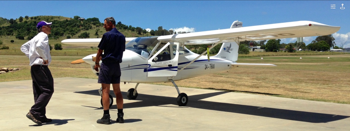
Yes, the P92 series like the Echo Super and the Eaglet are known to fly very nicely. Of course, your P96 is one of the low wing Tecnams but I think you'd find the handling qualities of the high wing cousins just as easy and pleasing. This is Mahl (on the left) at Boonah with one of his Eaglets a few years back.
-
Instructors in the Scenic Rim, Qld area?
Garfly replied to danny_galaga's topic in Student Pilot & Further Learning
I reckon Mahl Oakes at Fly Now! Redcliffe is a very simpatico instructor who's familiar with your neck of the woods. Plus he operates P92s if you want to stick to type. -
Some interesting observations by Scott Perdue in this vid. (He spends the first five minutes on what viewers got wrong in his previous video. This one starts in earnest after that. Perdue's video prompted this Comment (among others) from one CFI: @christophvz 2 years ago (edited) Thank you for another thoughtful and informative video Scott! These are excellent points and I fully agree with what you said. Your previous video inspired me to practice emergency landings in the real airplane (C182) and spend several hours in my BATD (Redbird TD2). One thing I’ve realized is that I’ve always taught my students just the abridged version - i.e. follow the ABC - Airspeed, Best Place to Land, Checklist. But now I’m realizing that there are more practical considerations that ought to be thought through carefully and practiced extensively. Below are some key points that I’m writing down in my CFI notes. Curious about feedback from other fellow pilots and instructors here. Emergency landing - key points 1. Pitch for Vdmms (defined minimum maneuvering speed, 1.404 x Vs, 72 kts in Cessna T182T), trim to reduce control pressure, and fly at that speed all the way to the ground; do not go above it and do not go below it until flare. Going above it will increase your kinetic energy which will be difficult to manage. Going below it will bring you closer to a stall and loss of control. Just fly Vdmms all the way to the ground. 2. Aim for the best available landing spot, ideally an open field, a runway, a road, a beach, dense trees, or water, in that order. Prioritize not hurting anyone on the ground before saving yourself. Runway is your second best option (unless you are in a tight traffic pattern already or in a high overhead position) because it will make it difficult to consider other options. I call it runway(titis). Aim for either straight in or low key position, or downwind high key position to your intended landing spot. 3. Continuously reevaluate if you can make your intended landing spot and choose the second best option if you know it’s not going to work out; judge if you can make it using your sight picture (i.e. angular distance); do not attempt to stretch the glide. If it’s not working out, accept your situation and remind yourself that your biggest risk is losing control of the airplane. So don’t. 4. Do not make turns below 500 feet; the loss in lift will induce an urge to pull back which will be extremely difficult to resist. Better to crash wings level into a suboptimal space than lose control close to the ground. You only need 30 ft of distance to stop and survive the 9G crash (see FAA flying handbook Chapter 17: Emergency Procedures). 5. Do not put full flaps until landing is 100% assured and you’re ready to flare. Unlatch the doors before touch down. Aim to be slightly high realizing that winds can shift close to the ground. Give yourself good safety buffer (i.e. avoid aiming for the edge of the field for example). 6. Evacuate promptly; do not just sit in the airplane thinking that the worst is behind you. It ain’t over till it’s over.
-
Country Airstrip Guide. What you think?
Garfly replied to NT5224's topic in AUS/NZ General Discussion
The last time I saw Franco was last May at Deeral.
-
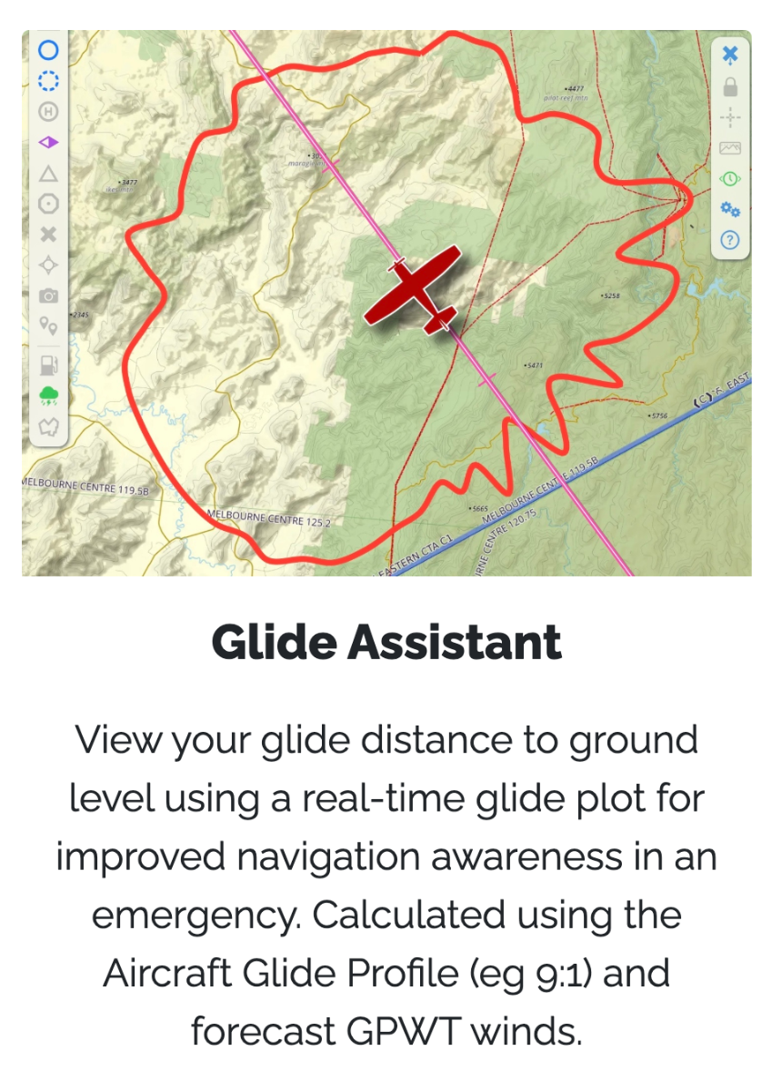
Whilst on the tricky topic of best-glide, I've found some of this discussion useful: Also, this vid is good at demonstrating that minimum sink is not the same as maximum range (wind effects aside): https://www.youtube.com/watch?v=ZP8KL4j9yA8 Also, I've been playing around with OzRwy's Glide Assistant in a simulator. It can can be used in planning and/or in real time. Not sure if, faced with an engine out situation you'd think to consult it but a quick glance might suggest a direction for longest range - in prevailing winds aloft. Anyway, it automatically cuts out at 1500' AGL probably in order to suggest that now is definitely look-outside time. User guidance here (18.5) : 18. Special Features DOCS.OZRUNWAYS.COM And this academic take is exhaustive (and exhausting) and might interest those who know the maths. Straight Gliding Flight | Academic Flight ACADEMICFLIGHT.COM This article deals with straight gliding flight, as it is encountered during an engine-out emergency or in a glider. Controlling (and maximizing) glide
-
Speaking of wooden propellers - a tall tale, and true, of the Canadian north.
-
It's sad to see young Ido Segev again, as large as life, in this wonderful Mike Rudd video. (He was one of the four pilots lost in the Mangalore mid-air tragedy.) https://www.theage.com.au/national/victoria/fly-ido-young-pilot-remembered-after-two-planes-crash-killing-four-20200220-p542ld.html
-
ABC article alleging "hobby aircraft" not safe
Garfly replied to ClintonB's topic in Aircraft Incidents and Accidents
But back then, we'd never have known each other, right? (And for all that, I reckon it's more for better than for worse ;- ) -
Aero Ex - Valkyrie 1 Design
Garfly replied to Peasant_Pilot's topic in Aircraft Building and Design Discussion
BTW P-P, Chris Weber, the builder of Valkyrie 1684, has said that he feels no special proprietary rights over the name for that one-off of his, so there'd be no need to change it on his account, at least. If you want to confirm that with him, let me know. -
ABC article alleging "hobby aircraft" not safe
Garfly replied to ClintonB's topic in Aircraft Incidents and Accidents
(Then there's the Philomena Cunk school of aviation journalism ;- ) -
Nambucca Heads light aircraft crash 04/01/2025
Garfly replied to trailer's topic in Aircraft Incidents and Accidents
Ch7 News: https://www.youtube.com/watch?v=CI2G7Yo8GZM -
Absolutely, they seem to worry him a lot ... even airframe parachutes worry him - a substitute for good piloting. That must please his GA Cirrus colleagues a lot. I guess their training is never going to save their lives. Equally opinionated folks worry about other things, like the dangers of a GA fleet full of 40 or 50 year old machines. And just look at that shiny RAAus, Bristell leading the story ... but a few years young. What a messed up piece of crap-journalism. Training saved pilot's life Pilot Keith Link from Cohuna in regional Victoria survived a plane crash after the engine of his commercially built Cessna failed mid-flight near Bendigo in 2020. He said his pilot training helped save his life but that more improvements in the sector were needed. Pilot Keith Link survived a light plane crash in 2020. (ABC News: Tyrone Dalton) Mr Link said he wanted licensed aircraft maintenance engineers to sign off on all aircraft after every 100 hours of flight or every 12 months. "When I see a plane with a parachute attached to it, I sort of think that's a substitute for being a good pilot," he said.