SDQDI
-
Posts
2,190 -
Joined
-
Last visited
-
Days Won
40
Content Type
Profiles
Forums
Gallery
Downloads
Blogs
Events
Store
Aircraft
Resources
Tutorials
Articles
Classifieds
Movies
Books
Community Map
Quizzes
Videos Directory
Everything posted by SDQDI
-
Frank could you quote the part where it mentions buying and maintains an airport in the ACT or VIC? I haven't read the article but it seems from what was quoted earlier that there wasn't any particular location in mind but it seemed to come off as multiple locations and NOT suggesting to buy them all, I think the words were "owning OR managing" This subject does have positives and negatives on both sides but reading things into either argument that aren't there doesn't really help either idea. I think it would be nice to have a discussion without doom and gloom.
-
So has anyone actually heard from Allianz or their broker in regards to this? I received my invitation to renew for another twelve months and intend paying it tonight but just wondered what the real story is.
-
I am personally more than happy to help people lower their asset base. No extra charge required, just a simple transfer of title. I am happy to take Land, Houses, Planes, and Boats. Other items will be on a case by case basis. Transferring assets to a spouse or other family member in NO way protects them contrary to bush lawyer folklore.
-

The XPB Stage 1 underway.
SDQDI replied to bexrbetter's topic in Aircraft Building and Design Discussion
To all my new buddies who down prawn cocktails? -
My main reason for liking chutes is for structural failure, it wouldn't be a nice feeling watching your wing depart with your chute neatly attached to it:sad angel: Not that I have heard of an over abundance of departing wings but I do always think about it.
-
Spats are good for loose surface stuff but I would hate to have them when landing on black soil mud, it will block them up quick smart! Yes you need to be a bit more careful and do good prop checks but it is still good fun. I haven't noticed any marked difference with a little mud under the wings but it would be wise to allow a little extra safety margin to your stall speed ect. I don't find plain mud as bad as mud with dirty puddles, the plain mud will stick to your wings worse but when combined with puddles it is easy to get a really dirty windshield very quickly which is something to be careful of.
-
Do you have a source for that Toady? It seems a couple of sources have said that it still had full power including the pax.
-
This is some good old 95:10 rules. Look at 6.1 © (iii) which refers also to 7.4. Basically from my quick look it basically says CTA is ok if you meet the same requirements for flight over 5000ft (if it is equipped with serviceable radiotelephone equipment and the pilot is qualified to use it) Civil Aviation Order 95.10 Instrument 2014
-
There seems to be a couple of posts that say there was NOT an engine failure, no doubt there was still a wtf mode but maybe not due to lack of engine power.
-
Morgan aeroworks cheetah sierra 100
SDQDI replied to Motobellini1098's topic in Aircraft General Discussion
A tailwheel version would fix the tipping back bit:thumb up: I do think a longer tail would look pretty nice though, would that also help with elevator authority? -
Common sense is off topic Greybeard!
-
I would think not. Actually I thought that 24 registered were also limited in their commercial endeavours to basically pilot training but I am too lazy to look up our manuals for the actual wording so I could be way off.
-
While I agree that physical lists are too much in simple singles I do think it is still important to run a mental one before important parts of flight. Otherwise it is a matter of time before something unusual surprises you. Something that shouldn't happen (like a passenger inadvertently activating the parking brake). It can very simple for example for me before landing it is BFHA B (brakes. Just a quick dab to see they have pressure and also a look to ensure park take valve is OFF) F (fuel. I don't like changing settings on fuel just before landing but always take time to double check my levels and taps.) H (harness. Just a little pull to tighten it a smidge, yes yes ever the optimist) A (airstrip. I take time to double check the wind direction and ensure the strip is clear) It takes me around 15 seconds and removes the major things that can cause me unnecessary grief. My before takeoff list is similarily short TFFP Trim, Flaps, Fuel, Power The TFF is done before takeoff power and the power is just a quick glance to ensure turbo is boosting and revs have reached Max after power is applied. Of course startup and run up are a little more involved but I think a quick checklist at those two fairly important stages of flight is an absolute must, without them you can probably fly safely for a long time but one day?????????
-
Might not hurt to read this https://www.governanceinstitute.com.au/media/839958/difference-between-private-and-public-company-structure-under-the-corporations-act_2015.pdf PS. RAA is NOT a pty ltd company but rather a company limited by guarantee. It is ok for people to bash RAA but at least get your facts straight first.
-
Savannah John just landed.... overheated
SDQDI replied to jaybee258's topic in Just Landed - Welcome
Your whites and pale colours are definitely lighter than dark colours, they are even lighter than their darker versions of themselves hence the names 'light blue' 'light green' 'light red' ect I learnded this in art class at big school. -
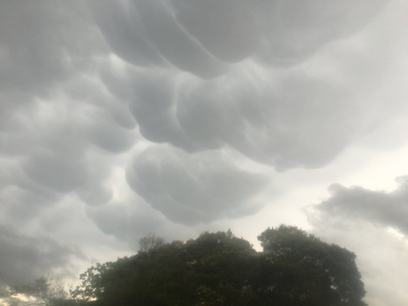
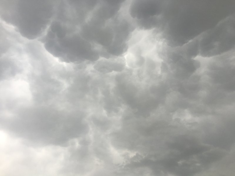
I didn't know what they were called Nev but did a quick bit of Wikipedia research and found these paragraphs. While they themselves are not too bad they were under a serious looking storm clouds. I do enjoy learning about clouds as there is so much info to take in and it seems no matter how many clouds you see you can still learn more and see something new. Mammatus are most often associated with the anvil cloud and also severe thunderstorms. They often extend from the base of a cumulonimbus, but may also be found under altocumulus, altostratus, stratocumulus, and cirrus clouds, as well as volcanic ash clouds.[citation needed] In the United States, sky gazers may be most familiar with the very distinct and more common cumulonimbus mammatus. When occurring in cumulonimbus, mammatus are often indicative of a particularly strong storm or maybe even a tornadic storm. Due to the intensely sheared environment in which mammatus form, aviators are strongly cautioned to avoid cumulonimbus with mammatus. They also attach to the bottom of other clouds. True to their ominous appearance, mammatus clouds are often harbingers of a coming storm or other extreme weather system. Typically composed primarily of ice, they can extend for hundreds of miles in each direction and individual formations can remain visibly static for ten to fifteen minutes at a time. While they may appear foreboding they are merely the messengers - appearing around, before or even after severe weather.
-
Spent most of the day out of the district thinking about the locals going to scone to watch the Hurricane (plane not weather phenomenon!) and got home to beautiful clouds like this. I haven't talked to any of the boys yet but am assuming that they had to drive down. Clouds like these encourage me to keep the hornet in the shed.

-
No need to rub it in! Our aero club was going down but I was away:pull hair:
-
Don't stress Bull. I posted my popcorn in a lighthearted manner as it seemed to me that you were mistaking Col's post as critical to you whereas I don't think he meant it that way and then Turbos post was (I assume again) aimed at me not you! I am fairly sure he was saying you were the one BEING bullied NOT being a bully and he was quite rightly gently reprimanding me for being immature so in a typical immature move I deliberately turned it around to mix it all up. Actually I am not sure about anything but I do assume that Col, Turbo and myself have NOT meant to come across as being against you in this matter. The internet does have a wonderful way of not putting the whole picture out there though so it is easy to read bad in good posts and good in negative posts.
-
For sure Turbs, but I think Col is big enough to handle being called a little fish so I personally wouldn't worry about that. Bull does come across as being a little over passionate but I don't think he means any harm and going by what he has said it sounds like someone has been hassling his family about him which never is a nice thing to have happen.
-
(Translates to "I don't know what is happening but I am amused anyway")
-
Lol Kasper I would say at a guess that jet was saying it would be nice if it was 'available' not 'mandatory' I do think it would be nice if maintence courses were available in more places and more regularly BUT it isn't really financially viable to do that as numbers are not huge. Also I definitely do NOT think they should be made mandatory.
-
I would have to say this is where I am at. If there are not more incidents caused by dodgy L1s than the other L groups then why does the system need changing at all? If it is a tick box exercise required by casa then I think a dodgy online test is a good idea rather than requiring everyone to attend a practical course. (Especially if the stats don't indicate an excess of incidents)
-
I must say though that I am not against voluntary practical courses being run but to make it an across the board thing seems very counter intuitive to 'affordable' flying.
-
The knowledge side has nothing to do with regulation. Making it mandatory to do a practical course to gain your L1 is extra regulation. How many extra maintenance related incidents were caused by the L1 group over the other L groups that prove this is necessary?