APenNameAndThatA
-
Posts
1,414 -
Joined
-
Last visited
-
Days Won
5
Content Type
Profiles
Forums
Gallery
Downloads
Blogs
Events
Store
Aircraft
Resources
Tutorials
Articles
Classifieds
Movies
Books
Community Map
Quizzes
Videos Directory
Everything posted by APenNameAndThatA
-
-

Words you should not use in ATC zones
APenNameAndThatA replied to Geoff_H's topic in Student Pilot & Further Learning
Controllers at Archerfield have always been polite. -
Words you should not use in ATC zones
APenNameAndThatA replied to Geoff_H's topic in Student Pilot & Further Learning
My biggest hint to learning what to say is to listen to your local airport on the an app on your phone. People learn speech best by imitation. You know what to say and what to expect people to reply. One day, I was completely not expecting, "On bravo, cross 04 right, cross 04 left, hold at bravo five for 10 left", so I did not do to well. -
Words you should not use in ATC zones
APenNameAndThatA replied to Geoff_H's topic in Student Pilot & Further Learning
So, do we say "to" and "four". If most people say "to" and "four" and a few people stop saying it, then that could cause more problems that people just saying "to" and "for". It seems to me that this might be the reason that people say "two thousand four hundred" instead of "two four hundred". Conclusions anyone? -
Find the left most edge of the horizon on the AH. Just above that is a blue box. (Assuming not rhetorical question.) 3 mph's
-
If it looks right, it'll fly right!
-
So the ND8 is makes everything darker, so the exposure is longer, so the prob blades are more blurred? Good idea.
-
Navs and removable sticky tape.
APenNameAndThatA replied to APenNameAndThatA's topic in Student Pilot & Further Learning
That would stop them wearing out. -
Downloading the app = endorsing Scomo's lies (to me). So, no.
-
I thought that flight traning was still perfectly legit?
-
English obviously first language.
-
QNH - practical application?
APenNameAndThatA replied to ayavner's topic in Student Pilot & Further Learning
I thought it could matter a lot. If someone was 200 feet high in the circuit and someone was 200 ft low overflying, then they could collide. Also, if planes in the circuit are not at the same height then it will make collisions more possible, especially as two planes that have not seen each other are approaching the threshold. Disclaimer: I have 50 hours. -
Passed my ride thanks to some of the answers here. Thanks.
-
question Brain teaser
APenNameAndThatA replied to Thruster88's topic in Student Pilot & Further Learning
I'm with Nev on this one. Thinking this through is not overthinking at all. It is important so that you know not to use ground speed as a proxy for airspeed. -
Navs and removable sticky tape.
APenNameAndThatA replied to APenNameAndThatA's topic in Student Pilot & Further Learning
P.S. You can also use the removable sticky tape to sticky tape shut the bits of the map that I was not going to need. Apart from that, I was just using the standard sheet with the headings and times, and a couple of checklists, especially the clear off checklist. -
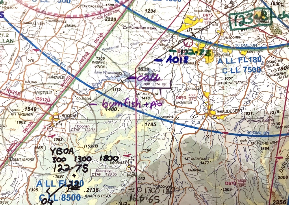
I managed to pass my nav flight, so I thought I would share some of my tricks - some of which came from here. I used removable sticky tape to write colour-coded cues for radio frequencies, altitudes, radio calls and transponder/ATIS/QNR and pre-landing checks. I drew five mile circles around all the aerodromes, and five and 10 mile circles around the aerodrome that I intended to land at. That prompted me to notify aerodromes when I was passing close to their pattern, and do landing checks (five miles) and do approach calls where I was landing (10 miles). By doing the call at exactly 10 miles, ETA = T + 7, in my plane. I also coloured the border of the different maps with different highlighters. That enabled me to get the correct side of the correct map easily. For my destination airport, I wrote the elevation, circuit height and overflying height, CTAF, runway names, and if the circuit was left or right (S or Z - shaped) so I could picture the runway names and dead side as I approached the aerodrome to overfly it. With the heights all written down, I would not have to do maths under pressure. I must say, none of this info is presented this way on electronic displays, so at the moment, I plan on using paper maps for navigation and GPS just to confirm my position. All comments welcome, and the more critical the better - negative feedback is valuable.

-
It’s all propaganda. All you ever hear about is how great bees are. Turns out they’re idiots.
-
I would try and get my money back. If you can't, then wait and see.
-
My A5 knee pad has a couple of transparent plastic sleeves that can contain checklists. I *love* the transparent plastic sleeves. And the pockets hold a wizz wheel and protractor/ruler and pens and pencils.
-
What I have taken from this discussion is *highlighter tape*. It is not at office works, but transparent, removable sticky tape is. So, I will be able to write on my chart in different colours of permanent marker, and then remove them after the flight! (I will continue with the PPPPPPPPPPPPP, writing on the map, and writing on the flight plan) Thanks! Highlighter tape is on Amazon.
-
RNC chart?
-
Good points. PPPPPPPPP, marking on the map, marking on the flight plan. Thanks!
-
As I am learning, I don't use GPS at all.
-
Hi. I have done about four LSA navs so far. I keep forgetting when to change the frequencies. Possible solutions that I can think off is to do the CLEAROFF check every couple of mintues and marking on the map in advance when to change to what frequency, or putting it on the flight plan where you mark down your altitudes and headings. Ideas? (CLEAROFF, in case you use a different acronym, is C Compass: DG L Log: ETA, ETD, SAR E Engine gauges A Altitude: QNH, plan, cloud R Radio frequency O Orientation (location) F Fuel: amount and tank F Forced landing spot)??
-
I think that what Turbo is saying is that if you just follow the magenta line, you will not have a clue when your fuel will run out, if you are in controlled airspace or what frequency you should be on.